
Ngāi Tahu, or Kāi Tahu, is the principal Māori iwi (tribe) of the southern region of New Zealand. Its takiwā is the largest in New Zealand, and extends from Blenheim, Mount Mahanga and Kahurangi Point in the north to Stewart Island in the south. The takiwā comprises 18 rūnanga corresponding to traditional settlements.
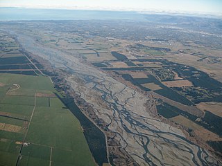
The Waimakariri River, formerly briefly known as the Courtenay River, is one of the largest of the North Canterbury rivers, in the South Island of New Zealand. It flows for 151 kilometres (94 mi) in a generally southeastward direction from the Southern Alps across the Canterbury Plains to the Pacific Ocean. In Māori, Waimakariri has several meanings, one of which is "river of cold rushing water". The river is known colloquially in Canterbury as "The Waimak".

Lake Ellesmere / Te Waihora is located in the Canterbury region of the South Island of New Zealand. It is actually a broad, shallow lagoon located directly to the west of Banks Peninsula, separated from the Pacific Ocean by a long narrow sandy spit called Kaitorete Spit, or more correctly Kaitorete Barrier. It lies partially in extreme southeastern Selwyn District and partially in the southwestern extension of the former Banks Peninsula District, which now is a ward in the city of Christchurch. The lake holds high historical and cultural significance to the indigenous Māori population and the traditional Māori name Te Waihora, means spreading waters. It has officially had a dual English/Māori name since at least 1938.
James Frederick Stuart-Wortley JP was a politician in New Zealand and the UK.

The Selwyn River / Waikirikiri flows through the Selwyn District of Canterbury in the South Island of New Zealand.
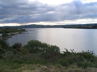
Lake Waihola is a 640 ha tidal freshwater lake located 15 km north of Milton in Otago, in New Zealand's South Island. Its area is some 9 square kilometres, with a maximum length of 6 kilometres and a mean depth of 0.75m.

Selwyn District is a predominantly rural area in central Canterbury, on the east coast of New Zealand's South Island. It is named after the Selwyn River, which is in turn named after Bishop George Selwyn, the first Anglican bishop of New Zealand who, in 1843 and 1844, travelled the length of the country by horse, foot, boat and canoe, leaving in his wake a sprinkling of locations that now bear his name.

Birdling's Flat, originally named Te Mata Hapuku, is a settlement in Canterbury, New Zealand, close to the shore of Lake Ellesmere / Te Waihora.
Akaroa was a New Zealand electorate. It was located in on Banks Peninsula, in Canterbury, and named after the town of the same name. One of the original 24 electorates, it existed from 1853 to 1893.
A losing stream, disappearing stream, influent stream or sinking river is a stream or river that loses water as it flows downstream. The water infiltrates into the ground recharging the local groundwater, because the water table is below the bottom of the stream channel. This is the opposite of a more common gaining stream which increases in water volume farther down stream as it gains water from the local aquifer.
The Architectural Centre Inc is a nonprofit organization in Wellington, New Zealand, for architects and laypeople with an interest in architecture which offers lectures, site visits, tours and exhibitions.

Lake Forsyth is a lake in the Canterbury region of New Zealand.

The Waipaoa River is a river of the northeast of New Zealand's North Island. It rises on the eastern slopes of the Raukumara Range, flowing south for 80 kilometres (50 mi) to reach Poverty Bay and the Pacific Ocean just south of Gisborne. For about half of this distance its valley is followed by State Highway 2. The river has several important tributaries, among them the Wharekopai, Waikohu, Mangatu, Waingaromia and Waihora rivers. Major settlements along the banks of the river include Te Karaka, Ormond, and Patutahi.
Te Karaka is a small settlement inland from Gisborne, in the northeast of New Zealand's North Island. It is located in the valley of the Waipaoa River close to its junction with its tributary, the Waihora River. Te Karaka is located on State Highway 2, and is the largest settlement between Gisborne and Opotiki in the Bay of Plenty.
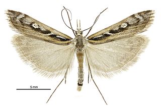
Kupea is a monotypic moth genus of the Crambidae family described by Alfred Philpott in 1930. It contains only one species, Kupea electilis, also known as Kupe’s grassmoth, which is endemic to New Zealand. It is classified as Nationally Vulnerable by the Department of Conservation. The female of the species was first discovered in 2012.
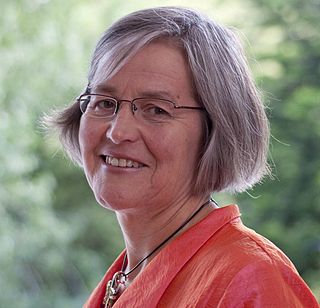
Eugenie Meryl Sage is a New Zealand politician and environmentalist. Since the 2011 election, she has been a Green Party list MP in the House of Representatives and currently serves as the Minister of Conservation and Land Information, as well as holding the Associate Minister for the Environment portfolio.

Pureora Forest Park is a 760-square-kilometre (290 sq mi) protected area in the North Island of New Zealand. Within its rich rain forest are an abundance of 1,000-year-old podocarp trees. It is "recognised as one of the finest rain forests in the world". Established in 1978, after a series of protests and tree sittings, the park is one of the largest intact tracts of native forest in the North Island and has high conservation value due to the variety of plant life and animal habitats available. New Zealand's largest totara tree is located nearby on private land.
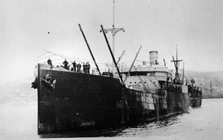
SS Waihora was a 4,638-ton cargo steamship built by Swan Hunter & Wigham Richardson, Tyne in 1907 for the Union Steam Ship Company of New Zealand. During the First World War she was chartered by the Royal Australian Navy and took part in operations against the German colonies in the Pacific with the Australian Naval and Military Expeditionary Force and later used by New Zealand as a troop transport as His Majesty’s New Zealand Transport. She was sold in 1927 to Naigai Kisen and renamed Tairyu Maru.

SS Waihora was a 2,003-ton passenger cargo steamship built by William Denny & Brothers, Dumbarton in 1882 for the Union Steam Ship Company of New Zealand.
Steamships named Waihora include:


