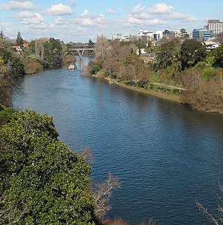
The Waikato River is the longest river in New Zealand, running for 425 kilometres (264 mi) through the North Island. It rises on the eastern slopes of Mount Ruapehu, joining the Tongariro River system and flowing through Lake Taupō, New Zealand's largest lake. It then drains Taupō at the lake's northeastern edge, creates the Huka Falls, and flows northwest through the Waikato Plains. It empties into the Tasman Sea south of Auckland, at Port Waikato. It gives its name to the Waikato region that surrounds the Waikato Plains. The present course of the river was largely formed about 17,000 years ago. Contributing factors were climate warming, forest being reestablished in the river headwaters and the deepening, rather than widening, of the existing river channel. The channel was gradually eroded as far up river as Piarere, leaving the old Hinuera channel through the Hinuera Gap high and dry. The remains of the old course are seen clearly at Hinuera, where the cliffs mark the ancient river edges. The Waikato's main tributary is the Waipā River, which converges with it at Ngāruawāhia.

The Taupō Volcanic Zone (TVZ) is a volcanic area in the North Island of New Zealand. It has been active for at least the past two million years and is still highly active.

The Ahaura River is in the South Island of New Zealand. This river drains the western flanks of the Southern Alps and flows into the Grey River.

The Buller River is a river in the South Island of New Zealand. The Buller has the highest flow of any river in the country during floods, though it is only the 13th longest river; it runs for 177 km (110 mi) from Lake Rotoiti through the Buller Gorge and into the Tasman Sea near the town of Westport. A saddle at 710 m (2,330 ft) separates the Buller from the Motupiko River and that is divided from the Wairau River by a 695 m (2,280 ft) saddle, both aligned along the Alpine Fault, as is the top of the Buller valley.

The Kawarau River is a river in the South Island of New Zealand. It drains Lake Wakatipu in northwestern Otago via the lake's Frankton Arm. The river flows generally eastwards for about 60 kilometres (37 mi) and passes through the steep Kawarau Gorge until it joins Lake Dunstan near Cromwell. Before the construction of the Clyde High Dam, the Kawarau joined the Clutha River / Mata-Au in a spectacular confluence at Cromwell. The Shotover River enters the Kawarau from the north; the Nevis River enters it from the south. With many rapids and strong currents, the river can be dangerous and has claimed many lives. It is popular for bungy jumping and kayaking.

The Hollyford River / Whakatipu Kā Tuka is in the southwest of the South Island of New Zealand. It runs for 72 kilometres (45 mi) through Fiordland, its sources being close to the Homer Tunnel and in Gertrude Valley in the southern Darran Mountains.

The Waioeka River is found in the north of New Zealand's North Island. It flows north for 65 kilometres (40 mi) from Te Urewera National Park to reach the sea at Ōpōtiki. It shares its estuary with the Ōtara River.

The Whakapapa River in New Zealand forms from streams which trickle off the Whakapapa skifield of Mount Ruapehu and down the western slopes of the mountain. The river passes near Ōwhango, before finally merging with the Whanganui River just east of Kakahi, about 40 km (25 mi) from where it starts, which is in a 100 m (330 ft) deep gorge, at the confluence of the Whakapapaiti and Whakapapanui Streams.

Te Urewera is an area of mostly forested, sparsely populated rugged hill country in the North Island of New Zealand, a large part of which is within a protected area designated in 2014, that was formerly Te Urewera National Park.
Hawke's Bay's Waiau River is one of at least four rivers of this name in New Zealand. It rises in the Kaingaroa Forest to the west of Lake Waikaremoana, and flows southeast for 60 kilometres before joining the Wairoa River.

The Wairoa River of the Hawke's Bay region in New Zealand runs south for 65 kilometres from the inland east coast region of the North Island, west of Gisborne, before flowing into northern Hawke Bay at the town of Wairoa.
Ormond is a small settlement inland from Gisborne, in the northeast of New Zealand's North Island. It is located on State Highway 2 in the valley of the Waipaoa River, halfway between Gisborne and the township of Te Karaka.

Rere is a small community in the northeast of New Zealand's North Island. it is located in the upper valley of the Wharekōpae River in remote country in the foothills of the Huiarau Range, inland from Gisborne. It is notable for the Rere Falls and Rere Rock Slide, both on the Wharekopae River.

State Highway 38 is a road in the North Island of New Zealand that starts from SH 5 near Waiotapu, and ends at Wairoa, where it connects to SH 2. It is the shortest connection from the central North Island (Rotorua) to the East Coast (Gisborne), but it is not often used as such. Large parts of the road are narrow and winding, and about 74 kilometres (46 mi) of the road is unsealed. Travel on this highway takes roughly four hours.
The Mangaaruhe River is a river of the Hawke's Bay Region of New Zealand's North Island. It flows southeast from the Ngamoko Range southwest of Lake Waikaremoana, flowing into the Wairoa River eight kilometres north of Frasertown.

The Mangapōike River is a river beginning in the Gisborne Region of New Zealand's North Island. It flows generally southwest from sources south of Waingake, reaching the Wairoa River in Hawke's Bay 10 kilometres (6 mi) northeast of Frasertown. Mangapōike River was Gazetted as an official name on 28 November 2022.
The Ruakituri River is a river of the Gisborne and Hawke's Bay Region of New Zealand's North Island. It initially flows northeast from its sources north of Lake Waikareiti. Within its course are the 72 m high Waitangi Falls. Afterwards it turns southeast for the majority of its course, reaching the settlement of Te Reinga, 25 kilometres (16 mi) north of Wairoa. It merges with the Hangaroa River resulting in the Wairoa River.

The Waiheke River is a river of the West Coast Region of New Zealand's South Island. It flows west from its origins on Mount Barron in the Southern Alps to reach the Ahaura River, which it forms where it joins the Tūtaekurī River, 20 kilometres northwest of Lake Sumner.
The Waikare River is a river in the Bay of Plenty Region of New Zealand' North Island. It flows north from its origins between the peaks of Matawhio and Papakai north of Lake Waikaremoana to reach the Whakatane River 25 kilometres (16 mi) east of Murupara.
Waiaua or Lower Waiaua is a rural community in the Ōpōtiki District and Bay of Plenty Region of New Zealand's North Island, located around the lower part of the Waiaua River.


