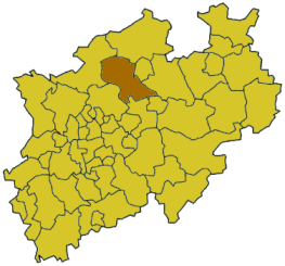
Coesfeld is a Kreis (district) in the northwestern part of North Rhine-Westphalia, Germany, west of the city of Münster. Neighboring districts are Steinfurt, district-free Münster, Warendorf, district-free Hamm, Unna, Recklinghausen, Borken.

The Taupo Volcanic Zone (TVZ) is a volcanic area in the North Island of New Zealand that has been active for the past two million years and is still highly active. Mount Ruapehu marks its south-western end and the zone runs north-eastward through the Taupo and Rotorua areas and offshore into the Bay of Plenty. It is part of the larger Central Volcanic Region that extends further westward through the western Bay of Plenty to the eastern side of the Coromandel Peninsula and has been active for four million years. The Taupo Volcanic Zone is widening east–west at the rate of about 8 mm per year. It is named after Lake Taupo, the flooded caldera of the largest volcano in the zone.
The Rangitaiki River is the longest river in the Bay of Plenty region in New Zealand's North Island. It is 155 kilometres (96 mi) long, and rises inland from northern Hawkes Bay to the east of the Kaingaroa Forest.
The Waioeka River is found in the north of New Zealand's North Island. It flows north for 65 kilometres (40 mi) from Te Urewera National Park to reach the sea at Opotiki. It shares its estuary with the Otara River.
Hawke's Bay's Waiau River is one of at least four rivers of this name in New Zealand. It rises in the Kaingaroa Forest to the west of Lake Waikaremoana, and flows southeast for 60 kilometres before joining the Wairoa River.

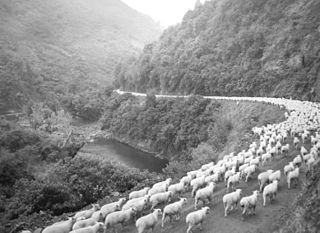
Portland Island, also called Waikawa, is a small island off the southern tip of the Mahia Peninsula on the North Island of New Zealand. It is used for sheep farming.

Taneatua is a small town in the Bay of Plenty region of New Zealand's North Island. The town is located southeast of Pekatahi, a similarly small settlement; Whakatane is the nearest significantly sized town. Just to the southwest of Taneatua, the Whakatane River and Waimana Rivers meet. The Whakatane River itself flows to the west of Taneatua, while the Waimana River is south of the township.

The Wairoa River of the Hawke's Bay region in New Zealand runs south for 65 kilometres from the inland east coast region of the North Island, west of Gisborne, before flowing into northern Hawke Bay at the town of Wairoa.

The Waipaoa River is a river of the northeast of New Zealand's North Island. It rises on the eastern slopes of the Raukumara Range, flowing south for 80 kilometres (50 mi) to reach Poverty Bay and the Pacific Ocean just south of Gisborne. For about half of this distance its valley is followed by State Highway 2. The river has several important tributaries, among them the Wharekopai, Waikohu, Mangatu, Waingaromia and Waihora rivers. Major settlements along the banks of the river include Te Karaka, Ormond, and Patutahi.
Te Karaka is a small settlement inland from Gisborne, in the northeast of New Zealand's North Island. It is located in the valley of the Waipaoa River close to its junction with its tributary, the Waihora River. Te Karaka is located on State Highway 2, and is the largest settlement between Gisborne and Opotiki in the Bay of Plenty.
Whatatutu is a small settlement in the northeast of New Zealand's North Island. It is located north of Te Karaka on the upper reaches of the Waipaoa River, close to its meeting with its tributaries, the Mangatu and Waingaromia Rivers.
The Hangaroa River is a river in the Gisborne Region of New Zealand. Its source is the Huiarau Ranges in the Te Urewera National Park, and flows southeast to merge with the Ruakituri River near Te Reinga. The combined rivers form the Wairoa River, which flows south into Hawke Bay.
The Koranga River is a river of the northeast of New Zealand's North Island. It lies to the east of Te Urewera National Park, to the southwest of the settlement of Matawai, and flows northwest to reach its outflow into the Waioeka River.
The Mangaaruhe River is a river of the Gisborne Region of New Zealand's North Island. It flows southeast from the Ngamoko Range southwest of Lake Waikaremoana, flowing into the Wairoa River eight kilometres north of Frasertown.
The Mangapoike River is a river of the Gisborne Region of New Zealand's North Island. It flows generally southwest from sources south of Waingake, reaching the Wairoa River 10 kilometres (6 mi) northeast of Frasertown.
The Mangatu River is a river of the Gisborne Region of New Zealand's North Island. It flows south from its sources in rough hill country northeast of Matawai to reach the Waipaoa River at Whatatutu.
The Ruakituri River is a river of the Hawke's Bay Region of New Zealand's North Island. A major tributary for the Wairoa River, it initially flows northeast from its sources north of Lake Waikareiti. It turns southeast for the majority of its course, reaching the Wairoa at the settlement of Te Reinga, 25 kilometres (16 mi) north of Wairoa.
The Urenui River is a river of the Taranaki Region of New Zealand's North Island. It flows northeast before turning northwest to reach the coast at Urenui.
The Waikaretaheke River is a river of the Hawke's Bay region of New Zealand's North Island. It serves as the outflow of Lake Waikaremoana, flowing southeast from the lake's southeastern shore to reach the Waiau River 20 kilometres northwest of Wairoa. State Highway 38 follows the river's course for much of its length.
The Waikare River is a river in the Bay of Plenty Region of New Zealand' North Island. It flows north from its origins between the peaks of Matawhio and Papakai north of Lake Waikaremoana to reach the Whakatane River 25 kilometres (16 mi) east of Murupara.


