Related Research Articles

The Bay of Pomerania is a basin in the southwestern Baltic Sea, off the Pomeranian shores of Poland and Germany. It stretches between the northernmost tip of the island of Rugia called Gellort northwest of Cape Arkona in the west, and the village of Jarosławiec in the east. In the south, it is bounded by the islands of Usedom/Uznam and Wolin, which separate it from the Szczecin Lagoon which is flown through by the Oder River, and is connected to the bay by three straits, the Dziwna, Świna, and Peenestrom.

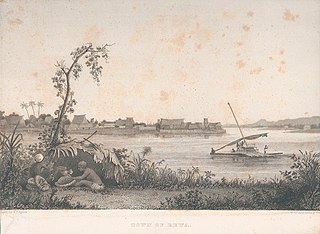
The Rewa River is the longest and widest river in Fiji. Located on the island of Viti Levu, the Rewa originates in Tomanivi, the highest peak in Fiji, and flows southeast for 145 km to Laucala Bay, near Suva. The Rewa River drains approximately one-third of Viti Levu.

The Central Division of Fiji is one of Fiji's four divisions. It consists of five provinces - Naitasiri, Namosi, Rewa, Serua and Tailevu.

Borchgrevink Glacier is a large glacier in the Victory Mountains, Victoria Land, draining south between Malta Plateau and Daniell Peninsula, and thence projecting into Glacier Strait, Ross Sea, as a floating glacier tongue, the Borchgrevink Glacier Tongue, just south of Cape Jones. It was named by the New Zealand Geological Survey Antarctic Expedition, 1957–58, for Carsten Borchgrevink, leader of the British Antarctic Expedition, 1898–1900. Borchgrevink visited the area in February 1900 and first observed the seaward portion of the glacier.

Gau is an island belonging to Fiji's Lomaiviti archipelago. Located at 18.00° S and 179.30 °E, it covers an area of 136.1 square kilometres, with a total shoreline that measures 66.3 kilometres long, making it the fifth largest island in the Fijian archipelago. Its maximum elevation is 738 metres (2,421 ft). To the north-west is Batiki, and to the north-east is Nairai.
The Ringgold Isles are an archipelago in Fiji, forming an outlier group to Vanua Levu. The Budd, Nukusemanu, and Heemskercq Reefs form part of the group. The group is mostly uninhabited, but Qelelevu has a small village. In 2008 Pacific rats were eradicated from seven islands of the group in an endeavour facilitated by BirdLife International's Fiji Programme.
Rewa is a province of Fiji. With a land area of 272 square kilometers, it includes the capital city of Suva and is in two parts — one including part of Suva's hinterland to the west and a noncontiguous area to the east, separated from the rest of Rewa by Naitasiri Province. The province had a population of 108,016 at the 2017 census, making it Fiji's third most populous.

Tailevu is one of the 14 provinces of Fiji. Its capital town is Nausori which lies along the banks of the Rewa River.
Gundamaian is a locality in the Royal National Park on the outskirts of southern Sydney, in the state of New South Wales, Australia. It is located about 2.5 km southeast of Gymea Bay on the southern side of Port Hacking.
Belize Botanic Gardens (BBG) is 45 acres (18 ha) of native and exotic plants growing in the Cayo district of western Belize. The garden is in a valley on the banks of the Macal River, surrounded by the Maya Mountain foothills.
Te Puia Springs is a village on the east coast of the North Island of New Zealand, located 103 km north of Gisborne.

Peral de Arlanza is a municipality and town located in the province of Burgos, Castile and León, Spain. According to the 2004 census (INE), the municipality has a population of 223 inhabitants.

The Tuross River, an open semi-mature wave dominated barrier estuary or perennial stream, is located in the South Coast region of New South Wales, Australia.
Vatuwaqa River is a river in the capital, Suva, on the island of Viti Levu, Fiji. The industrial zone at the river mouth is an example of land reclamation.

Rexford Glacier is a glacier flowing northeast into the head of Wagoner Inlet on the north side of Thurston Island. Named by Advisory Committee on Antarctic Names (US-ACAN) after Aviation Radioman Phillip W. Rexford, PBM Mariner aircrewman in the Eastern Group of U.S. Navy Operation Highjump, which obtained aerial photographs of this glacier and adjoining coastal areas, 1946–47.
Nakasi is a suburb located along the Suva-Nausori corridor, in the Central Division of the Republic of Fiji. The 9½ Miles factor is also used to identify the locality as it denotes the distance from Suva as it forms the common identification of the suburbs along the Kings Highway from Suva to Nausori. Nakasi is located 15 km north-east of Suva city and 5 km south of Nausori. It falls under the jurisdiction of the local government area of the township of Nausori. Nakasi is one of the largest of the many suburbs along the Suva-Nausori corridor. The current population stands at 18,919.
The Ministry of Foreign Affairs & International Cooperation is the ministry responsible for handling the Republic of Fiji's external relations. The ministry's current director is the Minister of Foreign Affairs and International Cooperation, Sitiveni Rabuka, who took the position in December 2022.
The Ogon River is a river located in Sanduan Province, Papua New Guinea. It is at an elevation of 2,707 meters above sea level.
References
18°05′S178°04′E / 18.083°S 178.067°E