
This is a list of the rivers of Fiji . They are listed by island in clockwise order, starting at the north end of each island. Tributaries are listed under the parent stream.
This is a list of the rivers of Fiji . They are listed by island in clockwise order, starting at the north end of each island. Tributaries are listed under the parent stream.
Fiji, officially the Republic of Fiji, is an island country in Melanesia, part of Oceania in the South Pacific Ocean. It lies about 1,100 nautical miles north-northeast of New Zealand. Fiji consists of an archipelago of more than 330 islands—of which about 110 are permanently inhabited—and more than 500 islets, amounting to a total land area of about 18,300 square kilometres (7,100 sq mi). The most outlying island group is Ono-i-Lau. About 87% of the total population of 924,610 live on the two major islands, Viti Levu and Vanua Levu. About three-quarters of Fijians live on Viti Levu's coasts, either in the capital city of Suva, or in smaller urban centres such as Nadi or Lautoka. The interior of Viti Levu is sparsely inhabited because of its terrain.
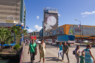
Suva is the capital and largest city of Fiji. It is the home of the country's largest metropolitan area and serves as its major port. The city is located on the southeast coast of the island of Viti Levu, in Rewa Province, Central Division.

Fiji is a group of volcanic islands in the South Pacific, lying about 4,450 kilometres (2,765 mi) southwest of Honolulu and 1,770 km (1,100 mi) north of New Zealand. Of the 332 islands and 522 smaller islets making up the archipelago, about 106 are permanently inhabited. The total land size is 18,272 km2 (7,055 sq mi). It has the 26th largest Exclusive Economic Zone of 1,282,978 km2 (495,361 sq mi).

Articles about people, places, things, and concepts related to or originating from Fiji, include:

Vanua Levu, formerly known as Sandalwood Island, is the second largest island of Fiji. Located 64 kilometres to the north of the larger Viti Levu, the island has an area of 5,587.1 square kilometres (2,157.2 sq mi) and a population of 135,961 as of 2007.
Viti Levu is the largest island in the Republic of Fiji. It is the site of the nation's capital, Suva, and home to a large majority of Fiji's population.

Labasa is a town in Fiji with a population of 28,500 at the most recent census held in 2010.

Taveuni is the third-largest island in Fiji, after Viti Levu and Vanua Levu, with a total land area of 434 square kilometres. The cigar-shaped island, a massive shield volcano which rises from the floor of the Pacific Ocean, is situated 6.5 kilometres east of Vanua Levu, across the Somosomo Strait. It belongs to the Vanua Levu Group of islands and is part of Fiji's Cakaudrove Province within the Northern Division.
Buca Bay is an isolated area on the Fijian island of Vanua Levu. The four villages within this bay are Vunikura, Loa, Buca and Tukavesi. It serves as a terminus for ferries that cross between Vanua Levu and Taveuni.
Nadroga-Navosa is one of the fourteen provinces of Fiji and one of eight based in Viti Levu, Fiji's largest island. It is about 2,385 square kilometers and occupies the South-West and Central areas of Viti Levu, Fiji's principal island. The province includes the Mamanuca Archipelago,Malolo Islands, off the west coast of Viti Levu, Vatulele, as well as the remote Conway Reef in the southwest. The population at the 2017 census was 58,931, being the fifth largest province. The main town in Nadroga-Navosa is Sigatoka, with a population of 9622.
Namosi is one of Fiji's fourteen provinces and one of eight based in Viti Levu, the largest island. Located to the west of Suva, the province covers 570 square kilometers. Its population of 7,871 at the 2017 census was the second smallest of any Fijian province.
Ratu Kinijoji R. Maivalili was a Fijian Chief and former political leader. From 2001 to 2006, he represented the Province of Cakaudrove in the Senate as one of fourteen nominees of the Great Council of Chiefs. Previously, he sat in the House of Representatives representing the Cakaudrove West Fijian Communal Constituency, which he won in 1999 but lost in 2001.

The Navua River is located in the island of Viti Levu in Fiji and has its source on the south east slope of Mount Gordon and flows for 65 kilometers to the south coast. It is noted for the rugged mountain country through which it flows. In the late 19th century, a sugar mill was built on the banks of this river, and although the mill was shut down in 1923, the town of Navua stands on its site.
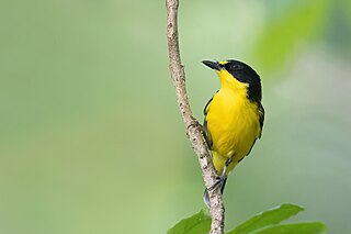
The Fiji whistler is a species of bird in the family Pachycephalidae, endemic to Fiji.
Vatuwaqa River is a river in the capital, Suva, on the island of Viti Levu, Fiji. The industrial zone at the river mouth is an example of land reclamation.
Manasa Ramasirai Vaniqi was a Fijian civil servant and lieutenant colonel. He was appointed Fiji's first Permanent Secretary for Sugar in 2009. As Permanent Secretary, Vaniqi oversaw reforms within the country's sugar industry. Under Vaniqi, the Ministry created the 2013–2017 Sugar Cane Industry Action Plan, which replaced the older Delloitte Report from New Zealand. Vaniqi also implemented future plans to diversify the focus of the sugar industry into newer, sustainable fields, such as ethanol and bio-gas production, which will be sold to the Fiji Electricity Authority (FEA) if the plans are successful. He met with chiefs and landowners on Vanua Levu and Viti Levu in an effort for increase sugarcane production and renew leases for sugar farmers. Vaniqi served as Permanent Secretary for Sugar from his appointment in 2009 until his death on January 1, 2015.
Seaqaqa is an unincorporated town in Fiji. It had a population of 394 in 1996, 816 in 2007, and 592 in 2017. The town has Seaqaqa F.C., a football club. Seaqaqa has a primary school, a college, and a health centre. Seaqaqa was the site of a brief and unsuccessful anti-colonial uprising in 1894. In the 1970s, an ambitious cane development scheme was realized in Seaqaqa.

Severe Tropical Cyclone Ana was one of three tropical cyclones to impact the island nation of Fiji towards the end of January 2021. The fifth tropical disturbance, third tropical cyclone and second severe tropical cyclone of the 2020–21 South Pacific cyclone season, Ana was first noted as Tropical Disturbance 05F during January 26, while it was located about 220 km (135 mi) to the northeast of Port Vila in Vanuatu. Over the next few days, the system moved eastwards and gradually developed further, before it was declared to be a tropical cyclone and named Ana during January 29. Over the next day, the system moved south-eastwards towards Fiji before it made landfall on the island of Viti Levu. After emerging into the Pacific Ocean, the system intensified into a Category 3 severe tropical cyclone, before it rapidly degenerated into a subtropical low during February 1.
Salome Tabuatalei is a Fijian athlete who competed at international level in a wide range of athletic events and in canoeing, from 1993 to 2019. She was named Fiji's Sportswoman of the Year in 1996 and 1997.