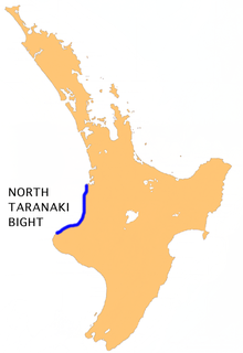
The North Taranaki Bight is a large bay that extends north and east from the north coast of Taranaki in New Zealand's North Island. The name is echoed by the South Taranaki Bight to the south of Cape Egmont.

The Orongorongo River runs for 32 kilometres (20 mi) southwest through the Orongorongo Valley in the southern Rimutaka Ranges of the North Island of New Zealand. The river and its associated catchments lie within the bounds of the Rimutaka Forest Park, which is administered by the Department of Conservation.

Whitford is a suburb in south-east Auckland, New Zealand. There are multiple versions of how the town was named. It may be named after Richard Whitford, a man who operated a flax mill on the Waikopua near Housons Creek and was the postman. Others think Whitford referred to the White-ford over the Turanga Creek at the end of Sandstone Road, where the salt dries when the tide is out. Another possibility is that it is named after Whitefoord Park part of a vast property belonging to L.D. Nathan was initially listed as ‘Whitefoord Park’ in Wises Post Office Directory for 1875-6, but by the time it went on sale for subdivision in 1903 it was known as Whitford Park.

The source of the Waitara River lies in the very steep hill country to the east of Mount Taranaki/Egmont, near Tahora. After proceeding in a southwesterly direction toward Central Taranaki, the river abruptly turns to flow in a northwesterly direction to the Tasman Sea: meeting it at the coastal town of Waitara.
The Waipawa River is a river of southern Hawke's Bay, in New Zealand's eastern North Island. It flows from the slopes of Te Atua Mahuru in the Ruahine Range southeast past the town of Waipawa before joining the Tukituki River.

The Mille River is a river of Ethiopia and a tributary of the Awash. It drains parts of the Semien (North) Wollo and Debub (South) Wollo Zones of the Amhara Region, as well as Administrative Zone 4 of the Afar Region. The explorer L.M. Nesbitt, who travelled through the area in 1928, was impressed by its size, and described the Mille as "probably the only real river which joins the Awash". The Ala River (A'ura) and Golima River (Golina) are small tributaries of the Mille.
The Mimi River is a river of the Taranaki Region of New Zealand's North Island. It flows generally southwest from its sources in rough hill country 25 kilometres northeast of Urenui to reach the sea five kilometres northeast of the town. State Highway 3 follows the valley of the Mimi River for part of its length.
The Omaumau River is a short river in the Auckland Region of New Zealand's North Island. It flows northwest to reach the Kaipara Harbour 20 kilometres (12 mi) northeast of Helensville.
The Oparau River is a river of the Waikato Region of New Zealand's North Island. It flows southwest from its sources in the Pirongia Forest Park and flows into the Kawhia Harbour 5 kilometres (3 mi) east of Kawhia.
The Papakanui River is a river of the Auckland Region of New Zealand's North Island. This short wide river forms part of the lower Kaipara Harbour system, adding its waters to the harbour close to the settlement of Tauhoa.
The Tawarau River is a river of the southern Waikato Region of New Zealand's North Island. It flows northwest to reach the Marokopa River 12 kilometres (7 mi) from the latter's outflow into the North Taranaki Bight.
The Tongaporutu River is a river of the Taranaki Region of New Zealand's North Island. It initially flows north from its origins near Tahora, turning west to reach the Tasman Sea coast close to the settlement of Tongaporutu, 15 kilometres south of Mokau.
The Urenui River is a river of the Taranaki Region of New Zealand's North Island. It flows northeast before turning northwest to reach the coast at Urenui.
The Waihoihoi River is a river of the Northland Region of New Zealand's North Island. it is a tributary of the Waipu River, which it reaches close to the town of Waipu.
The Wharehine River is a river in New Zealand. Located west of Wellsford, it is a tributary of the Oruawharo River.
Waikato's Manganui River is located close to the west coast of New Zealand's North Island. It flows south, parallel to the coast of the North Taranaki Bight, before flowing into the Awakino River 5 kilometres (3 mi) from the latter's mouth.

Coulston Glacier is a small tributary glacier flowing south from the Cartographers Range into Trafalgar Glacier, 10 nautical miles (19 km) west of Bypass Hill, in the Victory Mountains of Victoria Land. It was mapped by the United States Geological Survey from surveys and from U.S. Navy air photos 1960–64, and named by the Advisory Committee on Antarctic Names for Peter W. Coulston, an aviation electronics technician with U.S. Navy Squadron VX-6 at McMurdo Station, 1967.
Lowe Glacier is a tributary glacier 7 nautical miles (13 km) long in the Queen Elizabeth Range, Antarctica. It flows south from a common saddle with the Prince of Wales Glacier 3 nautical miles (6 km) east of Mount Gregory to join the Princess Anne Glacier. The name was proposed by the Holyoake, Cobham and Queen Elizabeth Ranges Party of the New Zealand Geological Survey Antarctic Expedition, 1964–65, after D. Lowe, a member of the party.
Skinner Saddle is a high, broad, snow-covered saddle between the northern part of Darley Hills and that portion of Churchill Mountains eastward of Mount Durnford. Mapped by the Northern Party of New Zealand Geological Survey Antarctic Expedition (NZGSAE) (1960–61) and named for D.N. Skinner, geologist with the party.
Motutieke Island is the largest of the many low-lying marshy islands in the delta of the Waikato River, New Zealand's longest river. Stretching for some 7 kilometres (4 mi), and close to 1,000 metres (3,300 ft) wide at its widest, the island is in reality two islands separated by a shallow channel. The main body of the Waikato River flows to the southeast of the island, with narrow channels separating it to the north from the mainland of New Zealand's North Island. The smaller Puehunui Island lies close to the northwest.


