The Taupo Volcanic Zone (TVZ) is a volcanic area in the North Island of New Zealand that has been active for the past two million years and is still highly active. Mount Ruapehu marks its south-western end and the zone runs north-eastward through the Taupo and Rotorua areas and offshore into the Bay of Plenty. It is part of the larger Central Volcanic Region that extends further westward through the western Bay of Plenty to the eastern side of the Coromandel Peninsula and has been active for four million years. The Taupo Volcanic Zone is widening east–west at the rate of about 8 mm per year. It is named after Lake Taupo, the flooded caldera of the largest volcano in the zone.
The Auckland Region is one of the sixteen regions of New Zealand, named for the city of Auckland, the country's largest urban area. The region encompasses the Auckland metropolitan area, smaller towns, rural areas, and the islands of the Hauraki Gulf. Containing 35 percent of the nation's residents, it has by far the largest population and economy of any region of New Zealand, but the second-smallest land area.

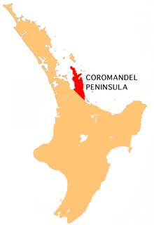
The Thames-Coromandel District is a territorial authority district in the North Island of New Zealand, covering all the Coromandel Peninsula and extending south to Hikutaia.
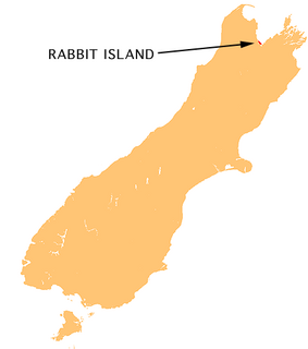
Moturoa / Rabbit Island is a small island located in the southernmost part of the Tasman Bay, in the northern coast of New Zealand's South Island. It lies across the southernmost part of Tasman Bay, at the top of New Zealand's South Island. The long narrow island runs east-west for 8 kilometres (5 mi), and covers 15 km2 (5.8 sq mi).
The Waihou River is located in the northern North Island of New Zealand. Its former name, Thames River, was bestowed by Captain James Cook in November 1769, when he explored 14 mi (23 km) of the river from the mouth. An older Māori name was "Wai Kahou Rounga". A 1947 Geographic Board enquiry ruled that the official name would be Waihou.

Whitianga is a town on the Coromandel Peninsula, in the Waikato Region of New Zealand's North Island. The town is located on Mercury Bay, on the northeastern coast of the peninsula. The town has a permanent population of 5,080 as of June 2018, making it the second-largest town on the Coromandel Peninsula behind Thames.
Clevedon, previously known as Wairoa South, is a rural town in Auckland, New Zealand, located in the Franklin ward, one of the thirteen administrative divisions of Auckland city. The town is governed by the Auckland Council. The town and surrounding rural area has a population of 2,508, and is the centre of an administrative ward of Manukau which takes in much of the largely rural area to the east of the urban heart of the city.

Reikorangi is a rural locality on the Kapiti Coast in New Zealand's North Island. It is inland, behind Waikanae in the Akatarawa Valley of the Tararua Ranges. The Ngatiawa River and Reikorangi Stream both meet the Waikanae River in Reikorangi. Reikorangi contains a church, a monastery, and formerly contained a school, which closed in 1970 due to the declining population of the small locality.
The Kopuaranga River is a river of the Wairarapa, in New Zealand's North Island. It flows generally south from rough hill country southwest of Eketahuna, reaching its outflow into the Ruamahanga River 5 kilometres (3 mi) north of Masterton.
The Kuaotunu River is a short river on the eastern Coromandel Peninsula on the North Island of New Zealand. It flows north towards the coast at Kuaotunu.
The Mahakirau River is a river of the Coromandel Peninsula in New Zealand's North Island. It flows east from its source in the Coromandel Range, reaching the sea at Whitianga Harbour southwest of Whitianga.
The Opitonui River is a river of the Coromandel Peninsula in New Zealand's North Island. It flows north to reach the peninsula's east coast at Whangapoua Harbour, close to the small settlement of Te Rerenga.
The Purangi River is a river of the Coromandel Peninsula in New Zealand's North Island. It flows north to reach Mercury Bay to the east of Whitianga.
The Rangiora River is a river of the Wellington Region of the North Island of New Zealand. It is a tributary of the Waikanae River, which it joins 5 kilometres (3 mi) southeast of Waikanae.
The Tapu River is a river of the Coromandel Peninsula in New Zealand's North Island. It flows west from the Coromandel Range, reaching the Firth of Thames at the settlement of Tapu, approximately halfway between Thames and Coromandel.
The Taumona River is a river of the Manawatu-Wanganui Region of New Zealand's North Island. It flows southwest from its origins 12 kilometres (7 mi) west of Taumarunui to reach the Ohura River.
The Tauranga River is a river of the Bay of Plenty Region of New Zealand's North Island. It flows north to reach the Waimana River close to the northern point of Te Urewera National Park.
The Te Mata River is a river of the Coromandel Peninsula in New Zealand's North Island. It flows west to reach the Firth of Thames at the small settlement of Te Mata, 25 kilometres (16 mi) south of Coromandel.
The Waitekuri River is a river of the Coromandel Peninsula in New Zealand's North Island. It flows east from its sources in the Coromandel Range east of Coromandel to reach Whangapoua Harbour four kilometres south of Whangapoua.
The Whenuakite River is one of the longer rivers on the Coromandel Peninsula, in the Waikato Region of New Zealand's North Island. It flows initially north from its sources close to the peninsula's southeast coast north of Tairua, before turning west to reach the southernmost point of the Whitianga Harbour.