
Sevier County ( "severe") is a county of the U.S. state of Tennessee. As of the 2010 census, the population was 89,889. Its county seat and largest city is Sevierville.

Washington County is a county located in the U.S. state of Indiana. As of 2010, the population was 28,262. The county seat is Salem.

West Lafayette is a city in Wabash Township, Tippecanoe County, Indiana, United States, about 65 miles (105 km) northwest of the state capital of Indianapolis and 103 miles (166 km) southeast of Chicago. West Lafayette is directly across the Wabash River from its sister city, Lafayette. As of the 2010 census, its population was 29,596. It is the most densely populated city in Indiana and is home to Purdue University.

Lake Junaluska is a census-designated place (CDP) in Haywood County, North Carolina, United States, in the Blue Ridge Mountains. It is part of the Asheville Metropolitan Statistical Area. Lake Junaluska is named after nearby Mount Junaluska, which in turn was named after Chief Junaluska, a Cherokee leader. As of the 2010 census the population of the community was 2,734.

Blue Bell is a census-designated place (CDP) in Whitpain Township in Montgomery County, Pennsylvania, in the United States. As of the 2010 census, its population was 6,067.

Pigeon Forge is a mountain resort city in Sevier County, Tennessee, in the southeastern United States. As of the 2010 census, the city had a total population of 5,875. Situated just 5 miles (8 km) north of Great Smoky Mountains National Park, Pigeon Forge is a tourist destination that caters primarily to Southern culture and country music fans. The city's attractions include Dollywood and Dollywood's Splash Country as well as numerous gift shops, outlet malls, amusement rides, and musical theaters.

The stock dove is a species of bird in the family Columbidae, the doves and pigeons. It is widely distributed in the western palearctic.

Sidney is a town located at the northern end of the Saanich Peninsula, on Vancouver Island in the Canadian province of British Columbia. It is one of the 13 Greater Victoria municipalities. It has a population of approximately 11,583. Sidney is located just east of Victoria International Airport, and about 6 km (4 mi) south of BC Ferries' Swartz Bay Terminal. The town is also the only Canadian port-of-call in the Washington State Ferries system, with ferries running from Sidney to the San Juan Islands and Anacortes. Sidney is located along Highway 17, which bisects the town from north to south. It is generally considered part of the Victoria metropolitan area.

Warracknabeal is a wheatbelt town in the Australian state of Victoria. Situated on the banks of the Yarriambiack Creek, 330 km north-west of Melbourne, it is the business and services centre of the northern Wimmera and southern Mallee districts, and hosts local government offices of the Shire of Yarriambiack. At the 2011 census Warracknabeal district had a population of 2,745, of which 2,340 lived in the town.

The District of North Saanich is located on the Saanich Peninsula of British Columbia, approximately 25 km (16 mi) north of Victoria on southern Vancouver Island. It is one of the 13 Greater Victoria municipalities. The District is surrounded on three sides by 20 km (12 mi) of ocean shoreline, and consists of rural/residential areas, a large agricultural base and is home to the Victoria International Airport and the Swartz Bay Ferry Terminal.

Caulfield South is a suburb in Melbourne, Victoria, Australia, 10 km south-east from Melbourne's central business district. Its local government area is the City of Glen Eira. At the 2016 Census, Caulfield South had a population of 11,854.

A quiggly hole, also known as a pit-house or simply as a quiggly or kekuli, is the remains of an earth lodge built by the First Nations people of the Interior of British Columbia and the Columbia Plateau in the U.S. The word quiggly comes from kick willy or keekwulee, the Chinook Jargon word for "beneath" or "under".

Nagarhole National Park is a national park located in Kodagu district and Mysore district in Karnataka, India. It is one of India's premier Tiger Reserves along with the adjoining Bandipur Tiger Reserve.

Maskwacis, renamed in 2014 from Hobbema, is an unincorporated community in central Alberta, Canada at intersection of Highway 2A and Highway 611, approximately 70 kilometres (43 mi) south of the City of Edmonton. The community consists of two Cree First Nations communities – one on the Ermineskin 138 reserve to the north and the other on the Samson 137 reserve to the south. It also consists of an adjacent hamlet within Ponoka County. The community also serves three more nearby First Nations reserves including Samson 137A to the south, Louis Bull 138B to the northwest, and Montana 139 to the south.
The Victoria Daly Regional Council is a local government area in the Northern Territory of Australia. The shire covers an area of 153,287 square kilometres (59,184 sq mi) and had a population of 3,138 in June 2018.
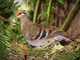
The brush bronzewing is a species of bird in the pigeon family, Columbidae. It is endemic to Australia, with two biogeographically distinct subspecies.

Victoria River is a locality in the Northern Territory of Australia located about 450 kilometres (280 mi) south of the territory capital of Darwin and about 240 kilometres (150 mi) south of the municipal seat in Katherine.
Yarralin, also known as Walangeri, is a remote Aboriginal community in the Northern Territory of Australia. At the 2016 census, Yarralin had a population of 293. The community is located on the banks of the Wickham River, about 15 km (9 mi) west of Victoria River Downs, a major cattle station along the Buchanan Highway.

The Wickham River is an ephemeral river, located in the Victoria Bonaparte bioregion of the Northern Territory in Australia.
The Karrangpurru were an indigenous Australian people of the Northern Territory. They suffered severe population loss very early on in the period of colonial expropriations of their land.
