
The ruins of Waldeck Castle (German : Burg Waldeck) are in the Upper Palatinate region of the state of Bavaria in Germany, on a hill overlooking the village of Waldeck, near Kemnath.
The ruins of Waldeck Castle (German : Burg Waldeck) are in the Upper Palatinate region of the state of Bavaria in Germany, on a hill overlooking the village of Waldeck, near Kemnath.
The castle in Waldeck was first built in the 12th century by Gebhardus der Waldegge the Landgrave of Leuchtenberg. [1]

The County of Waldeck was a state of the Holy Roman Empire and its successors from the late 12th century until 1929. In 1349 the county gained Imperial immediacy and in 1712 was raised to the rank of principality. After the dissolution of the Holy Roman Empire in 1806 it was a constituent state of its successors: the Confederation of the Rhine, the German Confederation, the North German Confederation, and the German Empire. After the abolition of the monarchy in 1918, the renamed Free State of Waldeck-Pyrmont became a component of the Weimar Republic until divided between Hannover and other Prussian provinces in 1929. It comprised territories in present-day Hesse and Lower Saxony (Germany).
Marburg-Biedenkopf is a Kreis (district) in the west of Hesse, Germany. Neighboring districts are Waldeck-Frankenberg, Schwalm-Eder, Vogelsbergkreis, Gießen, Lahn-Dill, Siegen-Wittgenstein.
Kassel district is a district in the north of Hesse, Germany. Neighboring districts are Northeim, Göttingen, Werra-Meißner, Schwalm-Eder, Waldeck-Frankenberg, Höxter. The independent city of Kassel is nearly completely surrounded by the district.
Waldeck may refer to:
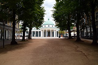
Bad Pyrmont is a town in the district of Hamelin-Pyrmont, in Lower Saxony, Germany, with a population close to 19,000. It is located on the river Emmer, about 10 km (6.2 mi) west of the Weser. Bad Pyrmont is a popular spa resort that gained its reputation as a fashionable place for princely vacations in the 17th and 18th centuries. The town is also the center of the Religious Society of Friends (Quakers) in Germany.

Bad Wildungen is a state-run spa and a small town in Waldeck-Frankenberg district in Hesse, Germany. It is located on the German Timber-Frame Road.

Wittekind Adolf Heinrich Georg-Wilhelm, Prince of Waldeck and Pyrmont has since 1967 been the head of the House of Waldeck and Pyrmont.
Bedok North Bus Depot is an SBS Transit East District bus depot located in Bedok, Singapore.

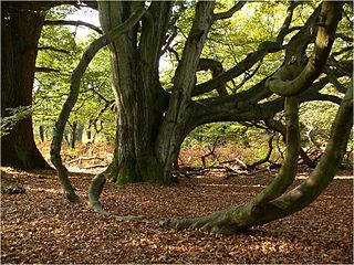
The Ruins of Waldeck, a spur castle, are located above the river Nagold near the town of Calw, Germany. They appear to be dated from the 12th century, but their exact origin is not well documented. The ruins are within the Black Forest, and the forest has partly covered the site, but there is still a well defined structure, the inside of which can be accessed by foot.

Arolsen Castle is a baroque-style schloss in Bad Arolsen, Hesse, Germany. The castle is now a museum, and is still inhabited by Wittekind, Prince of Waldeck and Pyrmont and his family.
Jaunā Māja is a village in Biksti Parish and Dobele Municipality in the historical region of Zemgale, and the Zemgale Planning Region in Latvia.
Si Pa Phìn is a commune (xã) and village of the Nậm Pồ District of Điện Biên Province in northwestern Vietnam.
Kokohoué is an arrondissement in the Kouffo department of Benin. It is an administrative division under the jurisdiction of the commune of Djakotomey. According to the population census conducted by the Institut National de la Statistique Benin on February 15, 2002, the arrondissement had a total population of 7,590.

Count Wolrad II 'the Scholar' of Waldeck-Eisenberg, German: Wolrad II. 'der Gelehrte' Graf von Waldeck-Eisenberg, was since 1539 Count of Waldeck-Eisenberg.

Count Wolrad IV 'the Pious' of Waldeck-Eisenberg, German: Wolrad IV. 'der Fromme' Graf von Waldeck-Eisenberg, official titles: Graf zu Waldeck und Pyrmont, was since 1588 Count of Waldeck-Eisenberg. He founded of the new line of Waldeck-Eisenberg.

Schaumburg Castle is a schloss in Rhineland-Palatinate, Germany, south of Balduinstein near Limburg an der Lahn.
Count Christian of Waldeck-Wildungen, German: Christian Graf von Waldeck-Wildungen, official titles: Graf zu Waldeck und Pyrmont, was since 1588 Count of Waldeck-Eisenberg and after the division with his brother in 1607 Count of Waldeck-Wildungen. He founded the new cadet branch of Waldeck-Wildungen and is the progenitor of the princes of Waldeck and Pyrmont.

The Château de Villiers-le-Mahieu is a modernised castle in the commune of Villiers-le-Mahieu in the Yvelines département of France. It was built in the 13th century and was extensively remodelled in the 17th. It is now in use as a hotel.

Vorderheubach is a district of the Heiligkreuzsteinach municipality in Odenwald. The place is with Lampenhain, Bärsbach, Hilsenhain and the small farm Hinerheubach district Lampenhain. The place belonged to Lampenhain community until 31 December 1974, and was then combined with Heiligkreuzsteinach. In the village live around 200 inhabitants.
Wyoming Township is a township in Jones County, Iowa.
49°51′30″N11°56′52″E / 49.8582°N 11.9478°E
| | This article about a Bavarian building or structure is a stub. You can help Wikipedia by expanding it. |
| | This article about a castle in Germany is a stub. You can help Wikipedia by expanding it. |