
The Electoral Palatinate or the Palatinate, officially the Electorate of the Palatinate, was a state that was part of the Holy Roman Empire. The electorate had its origins under the rulership of the Counts Palatine of Lotharingia in 915; it was then restructured under the Counts Palatine of the Rhine in 1085. These counts palatine of the Rhine would serve as prince-electors from "time immemorial", and were noted as such in a papal letter of 1261; they were confirmed as electors by the Golden Bull of 1356.

Count is a historical title of nobility in certain European countries, varying in relative status, generally of middling rank in the hierarchy of nobility. Especially in earlier medieval periods the term often implied not only a certain status, but also that the count had specific responsibilities or offices. The etymologically related English term "county" denoted the territories associated with some countships, but not all.

The Hunsrück is a long, triangular, pronounced upland in Rhineland-Palatinate, Germany. It is bounded by the valleys of the Moselle-Saar (north-to-west), the Nahe (south), and the Rhine (east). It is continued by the Taunus mountains, past the Rhine and by the Eifel past the Moselle. To the south of the Nahe is a lower, hilly country forming the near bulk of the Palatinate region and all of the, smaller, Saarland. Below its north-east corner is Koblenz.
Graf is a historical title of the German nobility, usually translated as "count". Considered to be intermediate among noble ranks, the title is often treated as equivalent to the British title of "earl".

The Rheingau is a region on the northern side of the Rhine between the German towns of Wiesbaden and Lorch near Frankfurt, reaching from the Western Taunus to the Rhine. It is situated in the German state of Hesse and is part of the Rheingau-Taunus-Kreis administrative district. It is famous for Rheingau wines, especially the "Rheingauer Riesling," and its many taverns.

The County Palatine of Veldenz was a principality in the contemporary Land Rhineland-Palatinate with full voting rights to the Reichstag. The county was located partially between Kaiserslautern, Sponheim and Zweibrücken, partially on the Mosel in the Archbishopric of Trier. A municipality of the same name, Veldenz, and a castle, Schloss Veldenz, are located in the district of Bernkastel-Wittlich.

Bärenbach is an Ortsgemeinde – a municipality belonging to a Verbandsgemeinde, a kind of collective municipality – in the Bad Kreuznach district in Rhineland-Palatinate, Germany. It belongs to the Verbandsgemeinde Kirner Land, whose seat is in the town of Kirn.

Hochstätten is an Ortsgemeinde – a municipality belonging to a Verbandsgemeinde, a kind of collective municipality – in the Bad Kreuznach district in Rhineland-Palatinate, Germany. It belongs to the Verbandsgemeinde of Bad Kreuznach, the seat of which is in the like-named town. Hochstätten is a winegrowing village. The municipality also markets itself as a recreational destination with the self-given nickname das Tor zur Pfalz im Erholungsgebiet Rheingrafenstein.

Neu-Bamberg is an Ortsgemeinde – a municipality belonging to a Verbandsgemeinde, a kind of collective municipality – in the Bad Kreuznach district in Rhineland-Palatinate, Germany. It belongs to the Verbandsgemeinde of Bad Kreuznach, whose seat is in the like-named town, although this lies outside the Verbandsgemeinde. Neu-Bamberg is a winegrowing village.

Pleitersheim is an Ortsgemeinde – a municipality belonging to a Verbandsgemeinde, a kind of collective municipality – in the Bad Kreuznach district in Rhineland-Palatinate, Germany. It belongs to the Verbandsgemeinde of Bad Kreuznach, whose seat is in the like-named town, although this lies outside the Verbandsgemeinde. Pleitersheim is a winegrowing village.

Bruchweiler is an Ortsgemeinde – a municipality belonging to a Verbandsgemeinde, a kind of collective municipality – in the Birkenfeld district in Rhineland-Palatinate, Germany. It belongs to the Verbandsgemeinde Herrstein-Rhaunen, whose seat is in Herrstein.

Kempfeld is an Ortsgemeinde – a municipality belonging to a Verbandsgemeinde, a kind of collective municipality – in the Birkenfeld district in Rhineland-Palatinate, Germany. It belongs to the Verbandsgemeinde Herrstein-Rhaunen, whose seat is in Herrstein.

Sien is an Ortsgemeinde – a municipality belonging to a Verbandsgemeinde, a kind of collective municipality – in the Birkenfeld district in Rhineland-Palatinate, Germany. It belongs to the Verbandsgemeinde Herrstein-Rhaunen, whose seat is in Herrstein.

Henschtal is an Ortsgemeinde – a municipality belonging to a Verbandsgemeinde, a kind of collective municipality – in the Kusel district in Rhineland-Palatinate, Germany. It belongs to the Verbandsgemeinde of Oberes Glantal.
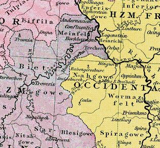
Speyergau was a medieval county in the East Frankish (German) stem duchy of Franconia. It was centred around the administrative centre of Speyer and roughly covered the former Roman administrative area of Civitas Nemetum, which is today the south-eastern portion of the Palatinate region between the Rhine river, the Palatinate Forest range, and some smaller parts of northern Alsace. The Speyergau, together with the neighbouring Wormsgau and Nahegau, was part of the major possessions held by the Salian dynasty of German kings and Holy Roman Emperors.
The Emichones were an early medieval family in the southwestern German region. Its members were counts (Gaugrafen) in the Nahegau, perhaps as undercounts of the Salian dynasty. The conventional name Emichones is due to the prevailing first name "Emich". Several later families may trace their origins to the Emichones.
The Nahegau was in the Middle Ages a county, which covered the environs of the Nahe and large parts of present-day Rhenish Hesse, after a successful expansion of the narrow territory, which did not reach the Rhine, to the disadvantage of the Wormsgau. Among other expansions were Ingelheim in 937, Spiesheim in 960, Saulheim in 973 and Flonheim in 996, until after the end of the expansion the Selz set the southern limit and the limit to the Wormsgau.
The Wormsgau was a medieval county in the East Frankish (German) stem duchy of Franconia, comprising the surroundings of the city of Worms and further territories on the left bank of the Upper Rhine river. Together with the neighbouring Nahegau and Speyergau, it belonged to the central Rhenish Franconian possessions of the Imperial Salian dynasty.
The Raugraves were a German noble family, which had its center of influence in the former Nahegau. They descended from the Emichones.
Simon II of Sponheim was a German nobleman. He was a member of the House of Sponheim and a ruling Count of the County of Sponheim.

