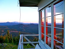
The Waldo Mountain fire lookout is located atop Waldo Mountain, in the Willamette National Forest, Oregon.
The original fire lookout tower was built on this site in 1926 and was a small cabin. In 1929 a cupola style lookout replaced the cabin. The current flat top lookout was built in 1956. [1] The lookout is currently unstaffed and no longer a functioning lookout. [2]
This is hike #90 in William Sullivan's 100 Hikes in the Central Oregon Cascades. [3] Sullivan describes the hike as a difficult 7.9 miles (12.7 km) loop with a 2,000' elevation gain.
The Three Sisters Wilderness is a wilderness area in the Cascade Range, within the Willamette and Deschutes National Forests in Oregon, United States. It comprises 286,708 acres (1,160.27 km2), making it the second largest wilderness area in Oregon, after the Eagle Cap Wilderness. It was established by the United States Congress in 1964 and is named for the Three Sisters volcanoes. The wilderness boundary encloses the Three Sisters as well as Broken Top, which is southeast of South Sister.
The Cascade–Siskiyou National Monument is a United States national monument that protects 114,000 acres (46,134 ha) of forest and grasslands at the junction of the Cascade Range and the Siskiyou Mountains in Southwestern Oregon and Northwestern California, United States. The monument is managed by the Bureau of Land Management as part of the National Landscape Conservation System. It was established in a presidential proclamation by President Bill Clinton on June 9, 2000 and expanded by President Barack Obama on January 12, 2017.
Black Butte is an extinct stratovolcano in the U.S. state of Oregon. Located in Jefferson County, it is part of Deschutes National Forest. Black Butte forms part of the Cascade volcanic arc. The butte lies just south of the Metolius Springs, which merge to form the headwaters of the Metolius River. The Metolius River's basin sustains a wide array of plant life, large and small mammals, and more than 80 bird species.
The Sky Lakes Wilderness is a wilderness area located in the Rogue River–Siskiyou and Fremont–Winema national forests in the southern Cascade Range of Oregon in the United States. It comprises 116,300 acres (47,100 ha), of which 75,695 acres (30,633 ha) are in the Rogue River–Siskiyou National Forest and 40,605 acres (16,432 ha) are in the Fremont–Winema National Forest. It was established in 1984 under the Wilderness Act of 1964.
The Mount Jefferson Wilderness is a wilderness area located on and around Mount Jefferson in the central Cascade Range of Oregon in the United States. The wilderness lies within the Willamette National Forest and Deschutes National Forest. The wilderness area covers 111,177 acres (449.92 km2), with more than 150 lakes. It also has 190 miles (310 km) of trails, including 40 miles (64 km) of the Pacific Crest National Scenic Trail. Three Fingered Jack and Mount Jefferson are both prominent features of the wilderness area. Mount Jefferson Wilderness is the second most visited Oregon wilderness area after the Three Sisters Wilderness.
The Badger Creek Wilderness is a 29,057-acre (11,759 ha) wilderness area located east of Mount Hood in the northwestern Cascades of Oregon, United States. It is one of six designated wilderness areas in the Mount Hood National Forest, the others being Mark O. Hatfield, Salmon-Huckleberry, Mount Hood, Mount Jefferson, and Bull of the Woods.
Olallie Butte is a steep-sided shield volcano in the Cascade Range of the northern part of the U.S. state of Oregon. It is the largest volcano and highest point in the 50-mile (80 km) distance between Mount Hood and Mount Jefferson. Located just outside the Olallie Scenic Area, it is surrounded by more than 200 lakes and ponds fed by runoff, precipitation, and underground seepage, which are popular spots for fishing, boating, and swimming. The butte forms a prominent feature in the Mount Jefferson region and is usually covered with snow during the winter and spring seasons.
Maiden Peak is a steep-sided shield volcano in the Cascade Range of central Oregon. It is the highest point in the 43-mile (69 km) distance between Mount Bachelor and Diamond Peak. Ice Age glaciers carved a large cirque into the northeast flank of the mountain, exposing magma which hardened in the volcano's conduits to form the numerous rock pinnacles now found in the upper part of the cirque.
Yamsay Mountain is a large shield volcano in the Cascade Range of south-central Oregon, located about 35 miles (56 km) east of Crater Lake on the border between Klamath County and Lake County. It is part of the Cascade Volcanic Arc but is located in a mountain range 30 to 50 miles behind the main Cascade volcanic front. The best known members of this enigmatic arc are the massive shields of Newberry Volcano, about 55 miles (89 km) farther north in Oregon, and Medicine Lake Volcano, about 80 miles (130 km) south in Northern California. Yamsay is the second highest volcano in the eastern arc, almost 300 feet (90 m) higher than Newberry and Medicine Lake.
Pelican Butte is a steep-sided shield volcano in the Cascade Range of southern Oregon. It is located 28 miles (45 km) due south of Crater Lake and 12 miles (19 km) northeast of Mount McLoughlin. Pelican Butte is the most prominent shield volcano in the southern Oregon Cascades and has a large volume at 4.8 cubic miles (20 km3), making it one of the bigger Quaternary volcanoes in the region, approaching the size of some of the range's stratovolcanoes. While still part of the Cascades, Pelican Butte is disconnected from the main axis, forming above faults along the eastern border of the range. Pelican Butte is part of the Quaternary Mount McLoughlin Reach, a volcanic vent zone that runs from the volcano to Aspen Lake, encompassing 33 vents over an area of 357 square miles (925 km2). Ice age glaciers carved a large cirque into the northeast flank of the mountain, but despite this erosion, its original shape is largely preserved. Several proposals have been made over the last few decades for the development of a ski area on this flank, but none have been implemented.
Waldo Lake Wilderness is a wilderness area surrounding Waldo Lake in the central Oregon Cascades. Located within the Willamette National Forest, it was established in 1984 and consists of 37,162 acres (15,039 ha).
The Watchman Lookout Station No. 168 is one of two fire lookout towers in Crater Lake National Park in southern Oregon. For many years, National Park Service personnel used the lookout to watch for wildfires during the summer months. It is also a common hiking destination because of its views of Crater Lake and the surrounding area. The building is unusual because it serves the dual purpose of fire lookout and museum. The Watchman Lookout Station is listed on the National Register of Historic Places.
The Musick Guard Station is a rustic cabin located in the Umpqua National Forest in western Oregon, United States. It was originally built to house fire crews assigned to patrol the surrounding National Forest. In the 1990s, the United States Forest Service began renting Musick Guard Station to recreational visitors. The Musick Guard Station is listed on the National Register of Historic Places.
Bagby Guard Station is a rustic cabin located in the Mount Hood National Forest in western Oregon, United States. It is adjacent to Bagby Hot Springs. The guard station was originally built to house fire crews assigned to patrol the surrounding National Forest. The Bagby Guard Station is listed on the National Register of Historic Places.
McCredie Springs is a hot springs and a former resort in Lane County, Oregon, United States. It is located near Oregon Route 58, 10.7 miles (17.2 km) east of Oakridge, and 50.7 miles (81.6 km) east of Eugene, within the Willamette National Forest. It is known for the nearby natural hot springs along Salt Creek.
Carpenter Mountain is a mountain located in Linn County, Oregon in the Willamette National Forest. It is part of the Cascade Range, and is one of the highest and easternmost peaks of the low-lying Western Cascades. A fire lookout on the summit was built in 1934 and has been recently reactivated for use. It marks the northernmost point in the H.J. Andrews Experimental Forest.
The Sourdough Mountain Lookout is a fire lookout that was built by the Civilian Conservation Corps in 1933. Constructed atop Sourdough Mountain in North Cascades National Park, in the U.S. state of Washington, the lookout was placed on the National Register of Historic Places in 1989.
Hager Mountain is a volcanic peak in Oregon in the northwest corner of the Basin and Range Province in the United States. The mountain is located south of the small unincorporated community of Silver Lake in south-central Oregon, and it is in the Fremont–Winema National Forest. On the summit, there is a fire lookout operated during the summer and fall by the United States Forest Service. There are several hiking trails that lead to the lookout station.
Crane Mountain is in the Warner Mountain range and is the tallest peak in Lake County, Oregon, U.S. It is located southeast of Lakeview in south-central Oregon, near the northwest corner of the Basin and Range Province of the western United States. The mountain is in the Fremont section of the Fremont–Winema National Forest. There was a United States Forest Service fire lookout located near the summit which was removed in 1972. The Crane Mountain National Recreation Trail runs north and south along the crest of the mountain.
William Lawrence Sullivan is an American author of outdoor guide books, histories, and fiction. He has written over twenty books, almost all of them related in some way to his home state of Oregon. Before he began his writing career, he attended several colleges, earning degrees from Cornell University and the University of Oregon. His "100 hikes" guide book series is especially popular with people who enjoy backpacking in Oregon's wilderness areas. In 2005, the Oregon Cultural Heritage Commission selected one of his books, Listening for Coyote, as one of the 100 most significant books in Oregon history.