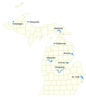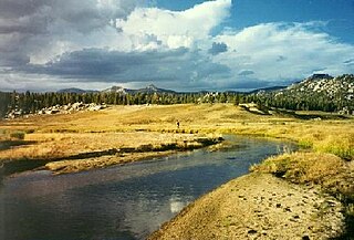
The Au Sable River in Michigan, United States runs approximately 138 miles (222 km) through the northern Lower Peninsula, through the towns of Grayling and Mio, and enters Lake Huron at Au Sable. It is considered one of the best brown trout fisheries east of the Rockies and has been designated a blue ribbon trout stream by the Michigan Department of Natural Resources. In French, au sable literally means "at the sand." A 1795 map calls it the Beauais River.

The Mad River is a stream located in the west central part of the U.S. state of Ohio. It flows 66 miles (106 km) from Logan County to downtown Dayton, where it meets the Great Miami River. The stream flows southwest from its source near Campbell Hill through West Liberty, along U.S. Route 68 west of Urbana, past Springfield, then along Ohio State Route 4 into Dayton. The stream's confluence with the Great Miami River is in Deeds Park.

Pine River may refer to any of the following streams in the U.S. state of Michigan:
- Pine River. The main branch forms with the confluence of the East and West Branches of the Pine River at 44°29′38″N83°23′16″W in Alcona County. The South Branch joins approximately 1.5 miles (2.4 km) to the south and flows into Iosco County, where it empties into Van Etten Lake at 44°29′38″N83°23′16″W northwest of Oscoda.
- Pine River. The main branch is formed by the confluence of the North and Middle Branches northeast of Standish and flows into the Saginaw Bay of Lake Huron at 43°58′32″N83°51′16″W. The South Branch Pine River joins the main stream at 43°59′08″N83°53′17″W.
- Pine River is a short waterway, which along with Round Lake, connects Lake Charlevoix with Lake Michigan at Charlevoix.
- Pine River rises in Chippewa County and flows south through Mackinac County into the St. Martin Bay of Lake Huron at 46°03′09″N84°39′22″W The North Pine River, also known as the North Branch Pine River, joins at 46°12′20″N84°36′17″W. Another tributary, Hemlock Creek, is also known as Pine River.
- Pine River, also known as the South Branch Manistee River, rises in southeast Wexford County, flows southwest across northwest Osceola County, then west and north through the northeast corner of Lake County and back into southwest Wexford County, emptying into the Tippy Dam Pond on the Manistee River at 44°13′37″N85°54′27″W. The main stream is formed from the confluence of the East Branch Pine River with the North Branch Pine River at 44°06′02″N85°31′40″W. Another tributary, the Spaulding Creek, is also known as the Little Pine River
- Pine River, in Marquette County, is a very short stream draining Pine Lake into Lake Superior at 46°53′27″N87°52′13″W, north of the Huron Mountains.
- Pine River rises in from Pine Lake in eastern Mecosta County, flows mostly south and east through Isabella County, then south along eastern edge of Montcalm County, then east and north through Gratiot County and Midland County, emptying into the Chippewa River at 43°36′06″N84°17′33″W, just about two miles before it joins the Tittabawassee River near Midland. The South Branch Pine River joins the main stream at 43°30′37″N85°00′02″W Another tributary, Miller Creek, is also sometimes known as Pine River or the West Branch Pine River. The North Branch Pine River joins the main stream at 43°26′03″N84°50′18″W.
- Pine River empties into the St. Clair River at 42°49′13″N82°29′08″W on the south side of St. Clair. The South Branch Pine River joins the main stream at 42°58′11″N82°37′10″W. Another tributary, Quakenbush Drain, is also sometimes known as Pine River.
- Pine Creek empties into Lake Superior and is also known as the Pine River.

The Rush River is a 49.8-mile-long (80.1 km) tributary of the Mississippi River in western Wisconsin in the United States. It rises just north of Interstate 94 in St. Croix County near Baldwin and flows generally southwardly through Pierce County. It ends in Lake Pepin of the Mississippi River, about 1 mile (2 km) west of the village of Maiden Rock in Pierce County. The largest tributary is Lost Creek.

The Conasauga River is a river that runs through southeast Tennessee and northwest Georgia. The Conasauga River is 93 miles (150 km) long and is home to 90 species of fish and 25 species of freshwater mussels. The Conasauga River watershed encompasses over 500,000 acres (2,000 km2) in two states, multiple counties, and two ecologically different regions.

The Chippewa River is a stream in the U.S. state of Michigan that runs 91.8 miles (147.7 km) through the central Lower Peninsula. The Chippewa is a tributary of the Tittabawassee River and is thus part of the Saginaw River drainage basin. The river is named after the Chippewa people.
Carp River is a 40.2-mile-long (64.7 km) river in Chippewa and Mackinac counties in the U.S. state of Michigan. 21.7 miles (34.9 km) of the river were added to the National Wild and Scenic Rivers System in 1992.

Penns Creek is a 67.1-mile-long (108.0 km) tributary of the Susquehanna River in central Pennsylvania in the United States.

Beech Creek is a 27.3-mile-long (43.9 km) tributary of Bald Eagle Creek in Centre and Clinton counties, in Pennsylvania in the United States.

Brodhead Creek is a 21.9-mile-long (35.2 km) tributary of the Delaware River in the Poconos of eastern Pennsylvania in the United States.

The Cedar River is a 29.0-mile-long (46.7 km) river in the U.S. state of Michigan, flowing through Clare County and Gladwin County.

The East Branch Brandywine Creek is a 27.4-mile-long (44.1 km) tributary of Brandywine Creek in Chester County, Pennsylvania in the United States.
Salt River is the name of two streams in the U.S. state of Michigan.
Coldwater River is a 13.1-mile-long (21.1 km) stream in the U.S. state of Michigan. Located in Isabella County, the river rises as the outflow of Littlefield Lake in western Gilmore Township. The river flows mostly south and empties into the Chippewa River at 43°37′22.231″N84°57′38.243″W on the western boundary of Deerfield Township, about two miles east of Lake Isabella.
Cedar Creek may refer to several small streams in the U.S. state of Michigan:

The South Fork Kern River is a tributary of the Kern River in the Sierra Nevada of the U.S. state of California. It is one of the southernmost rivers on the western slope of the mountains, and drains a high, relatively dry plateau country of 982 square miles (2,540 km2) along the Sierra Crest. The upper South Fork flows through a series of rugged canyons, but it also drains a flat, marshy valley before joining the Kern River at Lake Isabella.

The Saganing River, also known as Saganing Creek, is a 10.0-mile-long (16.1 km) stream in the U.S. state of Michigan.

Mountain Creek is a 20.9-mile-long (33.6 km) tributary of Yellow Breeches Creek in Cumberland County, Pennsylvania.
The Little Pigeon River is a 10.2-mile-long (16.4 km) stream in Otsego and Cheboygan counties in the U.S. state of Michigan.
The Baldwin River is a 25.2-mile-long (40.6 km) stream in the U.S. state of Michigan.


