Related Research Articles
Roblin is an unincorporated urban community in the Municipality of Roblin, Manitoba, Canada. It is located approximately 400 km (250 mi) northwest of Winnipeg.

Thompson is a city in north-central Manitoba, Canada, the largest city and most populated municipality in Northern Manitoba.

Northern Manitoba is a geographic and cultural region of the Canadian province of Manitoba. Originally encompassing a small square around the Red River Colony, the province was extended north to the 60th parallel in 1912. The region's specific boundaries vary, as "northern" communities are considered to share certain social and geographic characteristics, regardless of latitude.

Riding Mountain National Park is a national park in Manitoba, Canada. The park is located within Treaty 2 Territory and sits atop the Manitoba Escarpment. Consisting of a protected area of 2,969 km2 (1,146 sq mi), the forested parkland stands in sharp contrast to the surrounding prairie farmland. It was designated a national park because it protects three different ecosystems that converge in the area; grasslands, upland boreal and eastern deciduous forests. It is most easily reached by Highway 10 which passes through the park. The south entrance is at the townsite of Wasagaming, which is the only commercial centre within the park boundaries.

Cartwright is an unincorporated urban community in the Cartwright – Roblin Municipality within the Canadian province of Manitoba that held village status prior to January 1, 2015. It was originally incorporated as a village on December 31, 1947.

The Central Plains Region is an informal geographic region of the Canadian province of Manitoba located in the south central part of the Canadian province of Manitoba, directly west of Winnipeg.

Winnipeg Beach is a town in the Interlake Region, in the Canadian province of Manitoba. The town was founded in 1900 by Sir William Whyte and is located at the junction of Highway 9 and Highway 229 on the southwestern shore of Lake Winnipeg, about 56 kilometres (35 mi) north of Winnipeg. It is bordered by the Rural Municipality of Gimli, the Rural Municipality of St. Andrews, and Dunnottar as well as Lake Winnipeg. Nearby towns are Ponemah, Whytewold, and Matlock, Gimli, and Sandy Hook,, as well as Teulon, and Selkirk. Its permanent population is 1,439

Whiteshell Provincial Park is a provincial park in southeast Manitoba, approximately 120 kilometres (75 mi) east of the city of Winnipeg. The park is considered to be a Class II protected area under the IUCN protected area management categories. It is 275,210 hectares in size.

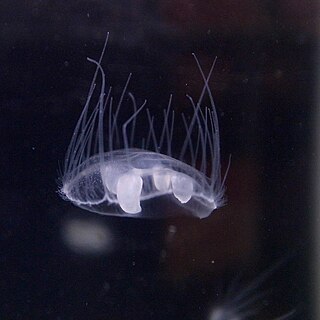
Craspedacusta sowerbii or peach blossom jellyfish is a species of freshwater hydrozoan jellyfish, or hydromedusa cnidarian. Hydromedusan jellyfish differ from scyphozoan jellyfish because they have a muscular, shelf-like structure called a velum on the ventral surface, attached to the bell margin. Originally from the Yangtze basin in China, C. sowerbii is an introduced species now found throughout the world in bodies of fresh water.

Nopiming Provincial Park is a natural provincial park in Manitoba, Canada, located on the southeast side of the province, along the boundary with Ontario.
Beaver Creek Provincial Park is a provincial park on Lake Winnipeg near the mouth of Beaver Creek in the North Interlake Region of Manitoba, Canada.

Highway 9 is a paved, undivided provincial highway in the Canadian province of Saskatchewan. It runs from North Dakota Highway 8 at the US border near Port of Northgate until it transitions into Provincial Road 283 at the Manitoba provincial boundary.
The Saskota Flyway is known as the International Road to Adventure, because it takes you from Hudson Bay, Saskatchewan, all the way south to Bismarck, North Dakota.

The Village of Dunnottar is a village in the Canadian province of Manitoba. As part of the Interlake and Metro regions, the municipality is located on the shores of Lake Winnipeg, just off Highway 9, south of Winnipeg Beach.

Killarney-Turtle Mountain is a rural municipality (RM) located in the Westman Region of Manitoba, Canada. It is located to the immediate north of the Canada–United States border opposite Rollete and Towner Counties, North Dakota.
Provincial Trunk Highway 21 is a provincial highway in the Canadian province of Manitoba. It runs from the U.S. border to PTH 45 and PR 577 in the village of Oakburn.

Gimli is an unincorporated community in the Rural Municipality of Gimli on the west side of Lake Winnipeg in Manitoba, Canada.

Grandview Municipality is a rural municipality (RM) in the Parkland Region of Manitoba, Canada. It is located in a valley between Duck Mountain Provincial Forest & Park and Riding Mountain National Park, which both lie partially within the RM's territory.

The Rural Municipality of Lakeshore is a rural municipality (RM) in the Parkland Region of Manitoba, Canada.

Patricia Beach Provincial Park is a provincial park on the south-east shore of Balsam Bay on Lake Winnipeg in Manitoba, Canada. The park is located within the Rural Municipality of St. Clements and can be accessed by road from Manitoba Provincial Road 319. In the summer, people relax by the lake on the fine sand beach. During the winter, people using snowmobiles or quads to go ice fishing on Balsam Bay get on to the lake from the south parking lot.
References
- ↑ "Angler's Atlas". www.anglersatlas.com. Retrieved 2024-08-13.
- ↑ "Parks and Protected Spaces | Environment and Climate Change | Province of Manitoba". www.gov.mb.ca. Retrieved 2024-08-13.