Cocke County is a county on the eastern border of the U.S. state of Tennessee. As of the 2020 census, the population was 35,999. Its county seat is Newport. Cocke County comprises the Newport, TN Micropolitan Statistical Area, which is part of the Knoxville-Morristown-Sevierville, Tennessee Combined Statistical Area.
Lake Lure is a town in Rutherford County, North Carolina, United States. In 2020 the town population was 1,365. Lake Lure was incorporated in 1927, and acquired the lake after which it is named in 1965.

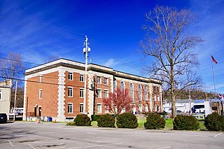
Newport is a city in and the county seat of Cocke County, Tennessee, United States. The population was 6,945 at the 2010 census, down from 7,242 at the 2000 census. The estimated population in 2018 was 6,801. Newport is located along the Pigeon River.

The French Broad River is a river in the U.S. states of North Carolina and Tennessee. It flows 218 miles (351 km) from near the town of Rosman in Transylvania County, North Carolina, into Tennessee, where its confluence with the Holston River at Knoxville forms the beginning of the Tennessee River. The river flows through the counties of Transylvania, Buncombe, Henderson, and Madison in North Carolina, and Cocke, Jefferson, Sevier, and Knox in Tennessee. It drains large portions of the Pisgah National Forest and the Cherokee National Forest.

The Pigeon River of Western North Carolina and East Tennessee rises above Canton, North Carolina, is impounded by Walters Dam, enters Tennessee, and flows into the French Broad River, just past Newport, Tennessee. The river traverses the Pisgah National Forest and the Cherokee National Forest, and drains much of the northeastern Great Smoky Mountains National Park.

The Taum Sauk pumped storage plant is a power station in the St. Francois mountain region of Missouri, United States about 90 miles (140 km) south of St. Louis near Lesterville, Missouri, in Reynolds County. It is operated by Ameren Missouri.

Lake Norman is a man-made fresh water lake in southwest North Carolina. The largest lake in the state, it was created between 1959 and 1964 as part of the construction of the Cowans Ford Dam by Duke Energy. Located in Iredell County, 15 miles north of Charlotte, Lake Norman State Park boasts the region's popular mountain biking trail system.

Duke Energy Corporation is an American electric power and natural gas holding company headquartered in Charlotte, North Carolina. The company ranked as the 141st largest company in the United States in 2024 – its highest-ever placement on the Fortune 500 list.

Lake Tillery is a reservoir between Falls Reservoir and Blewett Falls Lake in the Uwharrie Lakes Region of North Carolina. It is entirely within Stanly County and Montgomery County, NC. The lake was created by impounding the Pee Dee River, which is created by the confluence of the Yadkin River and the Uwharrie River several miles to the north. Norwood, NC in neighboring Stanly County uses as its town motto "Gateway to Lake Tillery".

Cowans Ford Hydroelectric Station is a hydroelectric power plant and dam located near Huntersville, North Carolina, approximately 20 miles north of Charlotte on Lake Norman. It is the largest conventional hydro station owned by Duke Energy, generating up to 350 MW of power.

Lake Keowee is a man-made reservoir in the United States in the state of South Carolina. It was developed to serve the needs of power utility Duke Energy and public recreational purposes. It is approximately 26 miles (42 km) long, 3 miles (4.8 km) wide, with an average depth of 54 feet (16 m), and a shoreline measured at 300 miles (480 km) in total, and is approximately 800 feet (240 m) above sea level.

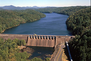
Douglas Dam is a hydroelectric dam on the French Broad River in Sevier County, Tennessee, in the southeastern United States. The dam is operated by the Tennessee Valley Authority (TVA), which built the dam in record time in the early 1940s to meet emergency energy demands at the height of World War II. Douglas Dam is a straight reinforced concrete gravity-type dam 1705 feet long and 202 feet high, impounding the 28,420-acre (11,500 ha) Douglas Lake. The dam was named for Douglas Bluff, a cliff overlooking the dam site prior to construction.

Hartford is an unincorporated community in Cocke County, Tennessee, located in the southeastern United States. Although it is not a census-designated place, the ZIP Code Tabulation Area for the ZIP Code (37753) that serves Hartford had a population of 814, according to the 2000 census.
Apalachia Dam is a hydroelectric dam on the Hiwassee River in Cherokee County, in the U.S. state of North Carolina. The dam is the lowermost of three dams on the river owned and operated by the Tennessee Valley Authority, which built the dam in the early 1940s to provide emergency power for aluminum production during World War II. While the dam is in North Carolina, an 8.3-mile (13.4 km) underground conduit carries water from the dam's reservoir to the powerhouse located 12 miles (19 km) downstream across the state line in Polk County, Tennessee. The dam and associated infrastructure were listed on the National Register of Historic Places in 2017. Apalachia Dam is classified by the U.S. Army Corps of Engineers as a high-hazard dam, meaning a dam failure may pose a deadly threat to nearby residents. The dam's condition is not made available to the public due to security concerns.

The Oconee Nuclear Station is a nuclear power station located on Lake Keowee near Seneca, South Carolina, and has a power output capacity of over 2,500 megawatts. It is the second nuclear power station in the United States to have its operating license extended for an additional twenty years by the Nuclear Regulatory Commission (NRC).

Mount Sterling is a mountain in the Great Smoky Mountains of Haywood County, North Carolina and Cocke County, Tennessee, located in the southeastern United States. It reaches an elevation of 5,842 feet (1,781 m) above sea level. The summit is topped by an abandoned fire tower that overlooks other nearby peaks.

Hiwassee Dam is a hydroelectric dam on the Hiwassee River in Cherokee County, in the U.S. state of North Carolina. It is one of three dams on the river owned and operated by the Tennessee Valley Authority, which built the dam in the late 1930s to bring flood control and electricity to the region. The dam impounds the Hiwassee Lake of 6,000 acres (2,400 ha), and its tailwaters are part of Apalachia Reservoir. At 307 feet (94 m), Hiwassee Dam is the highest overspill dam east of the Mississippi River and is second only to Grand Coulee dam in the nation. At the time it was completed, it was the highest overspill dam in the world.
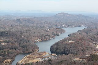
Lake Lure is a reservoir, located near the eponymous town of Lake Lure, North Carolina.

North Carolina was severely impacted by Hurricane Helene during late September 2024, primarily in its western Appalachian region, causing at least 96 reported deaths and significant destruction of infrastructure and residential areas across several settlements. After making landfall in the Big Bend region of Florida on September 27, the hurricane began to traverse over land across Georgia as a Category 2 hurricane and into the Appalachian mountain range as a tropical storm, depositing record-breaking amounts of rainfall across several settlements in western North Carolina, such as Asheville, Swannanoa, Spruce Pine, Chimney Rock, Montreat, Lake Lure, and several others.
The following is a list of events of the year 2024 in Tennessee.
