Related Research Articles
The prehistory of Australia is the period between the first human habitation of the Australian continent and the colonisation of Australia in 1788, which marks the start of consistent written documentation of Australia. This period has been variously estimated, with most evidence suggesting that it goes back between 50,000 and 65,000 years. This era is referred to as prehistory rather than history because knowledge of this time period does not derive from written documentation. However, some argue that Indigenous oral tradition should be accorded an equal status.
Australian archaeology is a large sub-field in the discipline of archaeology. Archaeology in Australia takes four main forms: Aboriginal archaeology, historical archaeology, maritime archaeology and the archaeology of the contemporary past. Bridging these sub-disciplines is the important concept of cultural heritage management, which encompasses Aboriginal and Torres Strait Islander sites, historical sites, and maritime sites.
Devil's Lair is a single-chamber cave with a floor area of around 200 m2 (2,200 sq ft) that formed in a Quaternary dune limestone of the Leeuwin–Naturaliste Ridge, 5 km (3.1 mi) from the modern coastline of Western Australia. The stratigraphic sequence in the cave floor deposit consists of 660 cm (260 in) of sandy sediments, with more than 100 distinct layers, intercalated with flowstone and other indurated deposits. Excavations have been made in several areas of the cave floor. Since 1973, excavations have been concentrated in the middle of the cave, where 10 trenches have been dug. Archaeological evidence for intermittent human occupation extends down about 350 cm (140 in) to layer 30, with hearths, bone, and stone artefacts found throughout. The site provides evidence of human habitation of Southwest Australia 50,000 years before the present day.
Aboriginal Australians have inhabited Western Australia from around 50,000–70,000 years ago to present.
Jean (Judy) Birmingham is a prominent English historical archaeologist, who has been based in Sydney, Australia, for most of her career. She is well known for her roles in the development of historical archaeology and cultural heritage management in Australia. In 2017 she was awarded a Member of the Order of Australia for her work in this field.

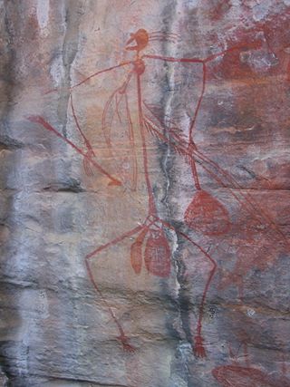
Gabarnmung is an archaeological and rock art site in south-western Arnhem Land, in the Top End of Australia’s Northern Territory. Habitation of the site has been dated to at least 44,000 years ago, placing it among the oldest radiocarbon dated sites in Australia. The oldest rock art was produced more than 28,000 years ago, making it the oldest securely dated prehistoric art in Australia. The cave was still visited by members of the Jawoyn within living memory, possibly until as late as the 1950s, but its existence had been forgotten until its 2006 rediscovery.
The Box Gully archaeological site is an Aboriginal archaeological site on the shore of saline Lake Tyrrell, in the Mallee region of northern Victoria, Australia. The site consists of the remains of a small hunting camp, which has produced radiocarbon dates of between 26,600 and 32,000 years BP, making Box Gully one of the earliest known occupied sites of the region and the first documentation of pre-30,000 calBP Aboriginal occupation of the extensive area between the Murray River and the Tasmanian highlands.
Cloggs Cave is a limestone cave and rockshelter with significant Aboriginal archaeological deposits, located on a cliff along the Snowy River gorge near the town of Buchan, Victoria.
Sisyphus Shelter is an archaeological site that was uncovered in Colorado when the Colorado Department of Highways was working on I-70. The excavation of this site became a joint project between the Colorado Department of Highways and the Bureau of Land Management. Fieldwork on the site was completed in 1980. Archaeologists John Gooding and Wm. Lane Shields as well as many others completed the excavation and prepared a comprehensive site report. Over the course of the fieldwork on Sisyphus Shelter, twenty-six features of human origin were discovered as well as numerous stone artifacts and two perishable items. The artifacts appeared to be all Late Archaic in origin. Dating indicated a range of occupations from modern times to 4400 B.P. being the oldest sample. Gooding and Shields (1985) suggest that the occupations of the shelter were not consistent and affected by seasonal changes.
Harry Lourandos is an Australian archaeologist, adjunct professor in the Department of Anthropology, Archaeology and Sociology, School of Arts and Social Sciences at James Cook University, Cairns. He is a leading proponent of the theory that a period of hunter-gatherer intensification occurred between 3000 and 1000 BCE.

The Jordan River is a perennial river located in the Midlands region of Tasmania, Australia.
Sandra Bowdler is an Australian archaeologist, emeritus professor of archaeology and former head of the Archaeology Department at the University of Western Australia.
Denison River is a river in South West Tasmania, Australia. It is within the South West Wilderness, and drains into the Gordon River below the Gordon Splits. Its catchment starts in the south of the King William Range.
Warratyi is the site of a rock shelter in the Flinders Ranges in South Australia. Located around 550 kilometres (340 mi) north of Adelaide and about 200 kilometres (120 mi) inland, it has been identified as the oldest known site of human habitation in inland Australia. Newspapers reported that this rock shelter was discovered by chance in 2011 by a local resident who stumbled upon it while looking for somewhere to go to the toilet. Researchers found thousands of artefacts and bone fragments, which enabled them to date the shelter's occupation to a number of periods between 49,000 and 10,000 years ago. The finds include the earliest evidence in Australia of the development of bone and stone-axe technology, the use of ochre, and interaction with megafauna such as Diprotodon.
Precipitous Bluff or PB is a mountain in the South West Wilderness of Tasmania located north east of New River lagoon.
Madjedbebe is a sandstone rock shelter in Arnhem Land, in the Northern Territory of Australia, possibly the oldest site of human habitation in Australia. It is located about 50 kilometres (31 mi) from the coast. It is part of the lands traditionally inhabited by the Mirarr, an Aboriginal Australian clan of the Gaagudju people, of the Gunwinyguan language group. Although it is surrounded by the World Heritage Listed Kakadu National Park, Madjedbebe itself is located within the Jabiluka Mineral Leasehold.
Angela McGowan is an Australian archaeologist known for her work on Aboriginal and European heritage and culture in Tasmania, Australia. McGowan predominantly worked in Heard Island, off the coast of Antarctica and Tasmania.
Charles Eugene Dortch is a US born archaeologist, largely known for his life and works in Western Australia.

Lang Rongrien is a rock shelter and Hoabinhian habitation site in the upland region of Krabi province in west-coast southern Thailand. The site is of the Pleistocene, early Holocene archaeological time frame. Excavations at the site began in 1974, and primary research was headed by Douglas Anderson. Though this rock shelter site is not as large as some others, it is archaeologically rich in its findings. Some of the sediment at the site was disturbed by soil collections, but not enough to have ruined the more impressive archaeological finds. The site is located within the Krabi River valley, in a somewhat hard-to-reach area that can only be accessed from a steep trail below the rock shelter, or a narrow ridge that approaches the rock shelter from the north. Radiocarbon dating at the site has put the evidence from between 39,000 and 28,000 years before present.
Katheryn Helen Morse was an Australian archaeologist who pioneered research on Pleistocene coastal archaeology in Western Australia.
References
- 1 2 Lourandos, Harry (1983). "10,000 Years in the Tasmanian Highlands". Australian Archaeology. 16 (16): 39–47. doi:10.1080/03122417.1983.12092879. ISSN 0312-2417. JSTOR 40286425.
- ↑ Porch, Nick; Allen, Jim (1995). "Tasmania: archaeological and palaeo-ecological perspectives". Antiquity. 69 (265): 714–732. doi:10.1017/S0003598X00082296. ISSN 0003-598X.
- ↑ Allen, Jim; Cosgrove, Richard; Brown, Steve (1988-12-01). "New Archaeological Data from the Southern Forests Region, Tasmania: A Preliminary Statement". Australian Archaeology. 27 (1): 75–88. doi:10.1080/03122417.1988.12093164. ISSN 0312-2417.
- ↑ Thomas, Ian (November 1993). "Late Pleistocene Environments And Aboriginal Settlement Patierns In Tasmania". Australian Archaeology. 36 (1): 1–11. doi:10.1080/03122417.1993.11681476. ISSN 0312-2417.
- ↑ Hiscock, Peter (2008). The archaeology of ancient Australia. London; New York: Routledge. ISBN 978-0-415-33810-3. OCLC 76935763.