Tasman District is a local government district in the north of the South Island of New Zealand. It borders the Canterbury Region, West Coast Region, Marlborough Region and Nelson City. It is administered by the Tasman District Council, a unitary authority, which sits at Richmond, with community boards serving outlying communities in Motueka and Golden Bay / Mohua. The city of Nelson has its own unitary authority separate from Tasman District, and together they comprise a single region in some contexts, but not for local government functions or resource management (planning) functions.
The Alfred River is a river in New Zealand's Tasman region. It runs west-southwest from its source in the Spencer Mountains to its junction with the Maruia River. The schist in the river contains hornblende.
Blackwater River is the name of three rivers in the northwestern South Island of New Zealand, one flowing into the Mangles River, one into the Buller River between Westport and Inangahua Junction, and one into the Māwheraiti River. All three rivers are within a few kilometres of each other, to the south and east of Westport.

The Buller River is a river in the South Island of New Zealand. One of the country's longest rivers, it flows for 170 kilometres (110 mi) from Lake Rotoiti through the Buller Gorge and into the Tasman Sea near the town of Westport. As Rotoiti itself is fed by the Travers River it can be claimed that the Buller's source is at the headwaters of the Travers, on the northern slopes of Mount Travers in the Saint Arnaud Range. The Paparoa Range separates the Buller River from the Grey River. A number of flora and fauna are found in the Buller watershed, many of these extending onto the slopes of the Paparoa Range.

The Kaiapoi River is a minor river of north Canterbury, in New Zealand's South Island. Originally called the Cam River, it is a tributary of the Waimakariri River, which it joins at the larger river's estuary. The river is 16 kilometres (10 mi) long, and its drainage area is about 430 square kilometres (170 sq mi).

New Zealand has a large number of hot springs, known as waiariki in Māori. Many of them are used for therapeutic purposes.

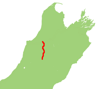
State Highway 65 is a New Zealand state highway in the South Island. It is 71 km long and runs south to north down the Maruia river valley from SH 7 at Springs Junction, 15 km west of the main divide at the Lewis Pass, to SH 6 in the Buller Gorge, 11 km west of Murchison. It forms part of the most direct route between Christchurch and Nelson. It takes its name from a small settlement toward its northern end.

State Highway 7 is a major New Zealand state highway. One of the eight national highways, it crosses the Southern Alps to link the West Coast Region with Canterbury and to form a link between the South Island's two longest highways, State Highway 1 and State Highway 6. Distances are measured from east to west with the major junction list going from east to west.
The Blue Grey River is a river of New Zealand. It is an upper tributary of the Grey River, flowing from Lake Christabel, close to the township of Maruia Springs, and flowing west for 8 kilometres (5 mi) before reaching the upper Grey River.
The Brown Grey River is a river of New Zealand. It is an upper tributary of the Grey River, flowing from the slopes of Mount Kemp, close to the township of Springs Junction, and flowing southeast for 10 kilometres (6 mi) before reaching the upper Grey River.
The Doubtless River is a river of northern Canterbury, New Zealand. A tributary of the Doubtful River, it rises south of Mount Boscawen and flows southward through the Lake Sumner Forest Park to join that river 2 kilometres (1.2 mi) east of Phantom Flat.

The Hanmer River is a river in the Hurunui District of New Zealand. It originates in the Hossack Saddle between the Hanmer Range and the Amuri Range, and flows south-west into the Waiau River about 8 kilometres (5.0 mi) south-west of Hanmer Springs.
The Rahu River is a river of the Tasman Region of New Zealand's South Island. It rises in two branches within Victoria Forest Park. From the junction of these two branches, the Rahu flows initially southeast before turning north to flow into the Maruia River five kilometres north of Springs Junction. State Highway 7 follows the upper course of the Rahu to the northwest of Springs Junction, crossing the Rahu Saddle into the valley of the Inangahua River.
The Rappahannock River is a river of the Tasman Region of New Zealand's South Island. It flows predominantly north from its sources east of Maruia, reaching the Warwick River five kilometres from the latter's outflow into the Maruia River.
The Shenandoah River is a river in New Zealand's West Coast Region. It flows northwest to reach the Maruia River 25 kilometres southeast of Inangahua.
The Upper Grey River is a river of the West Coast Region of New Zealand's South Island. As the name suggests, it is a stretch of the Grey River, and the name is used for the section between the confluence of the Blue Grey River, Brown Grey River, and Crooked Mary Creek in the Southern Alps and the Upper Grey's confluence with the Little Grey River 25 kilometres southwest of Reefton.
The Woolley River is a river of the West Coast Region of New Zealand's South Island. It initially flows east before turning north to reach the Maruia River close to the settlement of Maruia.

Lake Tennyson is a glacial high-country lake in Canterbury, New Zealand. The first European settler to see the lake was Frederick Weld in 1853, who also named it. The headwaters of the Clarence River are just to the north, and the river flows through Lake Tennyson.


