
Jackson County is a county located in the western portion of the U.S. state of Missouri. As of the 2010 census, the population was 674,158. making it the second-most populous county in the state. Although Independence retains its status as the original county seat, Kansas City serves as a second county seat and the center of county government. The county was organized December 15, 1826, and named for President Andrew Jackson. Jackson County is the central county of the Kansas City metropolitan area.

Washington is a city in, and the county seat of, Washington County, Kansas, United States. As of the 2010 census, the city population was 1,131.
Clifton is a city in Washington and Clay counties in the U.S. state of Kansas. As of the 2010 census, the city population was 554.

Fort Caspar was a military post of the United States Army in present-day Wyoming, named after 2nd Lieutenant Caspar Collins, a U.S. Army officer who was killed in the 1865 Battle of the Platte Bridge Station against the Lakota and Cheyenne. Founded in 1859 along the banks of the North Platte River as a trading post and toll bridge on the Oregon Trail, the post was later taken over by the Army and named Platte Bridge Station to protect emigrants and the telegraph line against raids from Lakota and Cheyenne in the ongoing wars between those nations and the United States. The site of the fort, near the intersection of 13th Street and Wyoming Boulevard in Casper, Wyoming, is listed in the National Register of Historic Places and is now owned and operated by the City of Casper as the Fort Caspar Museum and Historic Site.

Fort Kearny was a historic outpost of the United States Army founded in 1848 in the western U.S. during the middle and late 19th century. The fort was named after Col. and later General Stephen Watts Kearny. The outpost was located along the Oregon Trail near Kearney, Nebraska. The town of Kearney took its name from the fort. The "e" was added to Kearny by postmen who consistently misspelled the town name. A portion of the original site is preserved as Fort Kearny State Historical Park by the Nebraska Game and Parks Commission.
Camp Collins was a 19th-century outpost of the United States Army in the Colorado Territory. The fort was commissioned in the summer of 1862 to protect the Overland Trail from attacks by Native Americans in a conflict that later became known as the Colorado War. Located along the Cache la Poudre River in Larimer County, it was relocated from its initial location near Laporte after a devastating flood. Its second location downstream on the Poudre was used until 1866 and became the nucleus around which the City of Fort Collins was founded.
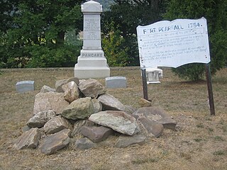
Fort Pearsall was an early frontier fort constructed in 1756 in Romney, West Virginia to protect local settlers in the South Branch Potomac River valley against Native American raids. The area around present-day Romney had been settled as early as 1725 by hunters and traders in the valley.
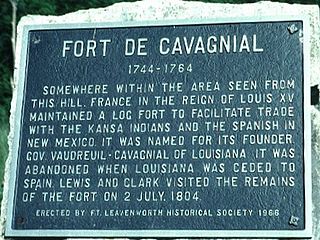
Fort de Cavagnial was a French fort on the west side of the Missouri River somewhere north of Kansas City, Kansas, and Fort Leavenworth, Kansas, from 1744 until about 1764.

Fort Harney was a United States Army outpost in eastern Oregon in the United States. It was named in honor of Brigadier General William S. Harney. Fort Harney was used as a supply depot and administrative headquarters from 1867 to 1880 during the Army's campaign against Northern Paiute bands in Eastern Oregon and the Bannock uprising in the same area. Today, nothing remains of Fort Harney except a small cemetery.
In the early 1860s Stephen B. Chapman and his family lived on a farm near the town of Black Jack, south of Lawrence, Kansas. In summer 1863 Bushwhackers began traveling through the area, terrorizing the citizens. After William C. Quantrill's Lawrence Massacre on August 21, 1863, the family in September moved west, since the guerrillas passed within sight of their farm.
Fort Belmont, in southern Woodson County, Kansas, was built about 1860 near the town of Belmont. It was to protect the settlers there from attacks by Border Ruffians and Indians. The fort consisted of three or four officer cabins, a redoubt about a quarter of a mile to the north and a parade ground a mile to the east.
Fort Brooks, in northwest Clay County, Kansas, was located three miles west of Clifton, Kansas. Built on the north bank of the Republican River in August or September 1864, it was named for George D. Brooks. Brooks, an ensign in the Shirley County Militia, owned the farm on which the fort was located. Capt. Isaac M. Schooley, the militia commander, was also the fort's commander.
In 1864 Gen. Samuel R. Curtis established a military camp at the Fort Riley-Fort Larned Road crossing of the Smokey Hill River in what is now Ellsworth County, Kans.
Fort Row, located on the south bank of the Verdigris River and east of the present town of Coyville, Kansas, was built in the fall of 1861, probably in October. It was built by the local mounted militia for their use. However, the fort became associated with one of the worst human tragedies of the Civil War.

Bald Hills War (1858–1864) was a war fought by the forces of the California Militia, California Volunteers and soldiers of the U. S. Army against the Chilula, Lassik, Hupa, Mattole, Nongatl, Sinkyone, Tsnungwe, Wailaki, Whilkut and Wiyot Native American peoples.
In early 1864 settlers in Ottawa County, Kansas, began building Fort Solomon and completed it by the spring or summer. This structure replaced the much smaller dugout owned by the Chapman family and used as a refuge in times of trouble. The Chapman dugout was about a mile south of Fort Solomon. The new white settlers and the Indians in the area quickly developed a hostile relationship and many Indian raids followed.

Lindsey is an unincorporated community in Ottawa County, Kansas, United States, less than 1-mile (1.6 km) southeast of Minneapolis, Kansas. A railroad line belonging to Kyle Railroad runs through the center of the townsite. The railroad does not have a siding or stop in Lindsey. Only one road, North 135th Road, runs through the community. Lindsey consists of about a half dozen residences.
Salina's Stockade was built in Salina, Kansas, to provide the residents with protection from the American Indians in the area, many of whom were hostile toward white settlement. While Salina had been raided in 1862 by Native Americans and then Confederate guerrillas, it was not until May 1864 when residents decided they needed to build a stockade for protection. On May 17, 1864, a makeshift stockade, consisting of wagons placed in a circle around the town's flagpole, was erected. The local militia then drilled and guarded Salina. On the northeast corner of 7th Street and Iron Avenue stood a small building. Around this a permanent stockade was erected in May and June 1864.
In 1842 a large log fort was built at Trading Post by the United States Army, upon the order of Gen. Winfield Scott. This fort was on the Fort Leavenworth-Fort Gibson Military Road. The completed fort was fairly elaborate. It included space to house a company of dragoons and their horses. Also, it contained a hospital and store houses. Gaps along the outside walls of buildings were filled in with stockade walls. The buildings were built around a large interior open area.


