
U.S. Route 9 (US 9) is a north–south United States Numbered Highway in the states of Delaware, New Jersey, and New York in the Northeastern United States. It is one of only two U.S. Highways with a ferry connection ; the other is US 10. US 9 is signed east–west in Delaware and north–south on the rest of its route. The southern terminus of the route is in Laurel, Delaware, at an intersection with US 13, while the highway's northern terminus is at a junction with Interstate 87 (I-87) in Champlain, New York, where the old roadway continues north as the unsigned New York State Route 971B (NY 971B), which ends in a cul-de-sac just short of the Canadian border.
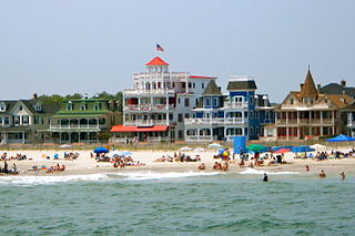
Cape May is a city and seaside resort located at the southern tip of Cape May Peninsula in Cape May County in the U.S. state of New Jersey. Located where the Delaware Bay meets the Atlantic Ocean, it is one of the country's oldest vacation resort destinations. The city, and all of Cape May County, is part of the Ocean City metropolitan statistical area, and is part of the Philadelphia-Wilmington-Camden, PA-NJ-DE-MD combined statistical area, also known as the Delaware Valley or Philadelphia metropolitan area.

Route 109 is a 3.06-mile (4.92 km) state highway located in Cape May County, New Jersey, United States. The route runs from Jackson Street in Cape May north to an intersection with U.S. Route 9 in Lower Township. It crosses one of two road bridges over the Cape May Canal and provides access to the southern end of the Garden State Parkway and County Route 621 as well as to Cape May. Only the section of road in Lower Township is state maintained; the rest is maintained by Cape May County and signed as County Route 633, which extends 0.34 mi (0.55 km) past the southern terminus along Jackson Street and Perry Street to CR 626 in West Cape May.

The Cape May–Lewes Ferry is a ferry system in the United States that traverses a 17-mile (27 km) crossing of the Delaware Bay connecting North Cape May, New Jersey with Lewes, Delaware. The ferry constitutes a portion of U.S. Route 9 and is the final crossing of the Delaware River-Delaware Bay waterway before it meets the Atlantic Ocean. It is only one of two direct crossings between Delaware and New Jersey, the other being the Delaware Memorial Bridge.

The Delaware Valley, sometimes referred to as Greater Philadelphia or the Philadelphia metropolitan area, is a major metropolitan region in the Northeast United States that centers around Philadelphia, the nation's sixth-most populous city, and spans parts of four U.S. states: southeastern Pennsylvania, southern New Jersey, northern Delaware, and the northern Eastern Shore of Maryland. With a core metropolitan statistical area population of 6.288 million residents and a combined statistical area population of 7.366 million as of the 2020 census, the Delaware Valley is the eighth-largest metropolitan region in the United States and the 68th-largest metropolitan region in the world.

Congress Hall is a historic hotel in Cape May, Cape May County, New Jersey, United States, occupying a city block bordered on the south by Beach Avenue and on the east by Washington Street Mall. It is a contributing building in the Cape May National Historic District.

Downtown Crossing is a shopping district within downtown Boston, Massachusetts, located east of Boston Common, west of the Financial District, south of Government Center, and north of Chinatown and the old Combat Zone. It features large department stores as well as restaurants, souvenir sellers, general retail establishments, and street vendors. The Downtown Crossing MBTA station lies in the center of the district.

The Wildwoods are a group of five communities in Cape May County, New Jersey. These are situated on the Island of Five Mile Beach, a barrier island facing the Atlantic Ocean. These Jersey Shore communities have relatively small year-round populations that swell significantly during the summer with vacationers.
The Washington City Canal was a canal in Washington, D.C., that operated from 1815 until the mid-1850s. The canal connected the Anacostia River, termed the "Eastern Branch" at that time, to Tiber Creek, the Potomac River, and later the Chesapeake and Ohio (C&O) Canal. The canal fell into disuse during the late 19th century and the city government covered over or filled in various sections in 1871.
The Seacourt Pavilion is a regional shopping center on Hooper Avenue in Toms River, New Jersey. It is right across the street from the Ocean County Mall. The mall has a gross leasable area of 253,000 sq ft (23,500 m2).

Seaview Square Mall was a shopping mall located in Ocean Township, in Monmouth County, New Jersey, United States. It has been repurposed as a power center and was renamed Seaview Square Shopping Center in 2012. The 856,000-square-foot (79,500 m2) mall, located at the intersection of Route 35 and Route 66, was originally constructed in 1977 as an indoor mall. It faced stiff competition from the more upscale Monmouth Mall, located five miles (8 km) further north on Route 35 in Eatontown. One of its four anchors never opened, and several smaller stores, and Stern's and Steinbach, two of its anchors, were victims of the then-indoor mall's then-state of decline. The mall was later redeveloped into a shopping center with Target, Costco, Burlington, Home Sense, Siera Trading, Marshalls, Home Goods, Petsmart, Starbucks, and others.
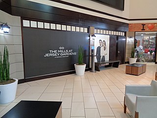
The Mills at Jersey Gardens, originally and also still colloquially called Jersey Gardens, is a two-level indoor outlet mall in Elizabeth, New Jersey. The mall opened on October 21, 1999, and is the largest outlet mall in New Jersey, and much closer to New York City than its largest outlet mall competitor, Woodbury Common.

South Cape May was a borough that existed in Cape May County, New Jersey, United States, from 1894 to 1945. First settled in 1840, it contained a Lucy-type elephant called Light of Asia.

The Emlen Physick Estate is a Victorian house museum in Cape May, New Jersey. The estate is located at 1048 Washington Street.
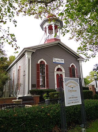
The Cape May Stage is a theatre company that performs in the Robert Shackleton Playhouse located at the corner of Bank and Lafayette Streets in downtown Cape May, New Jersey, United States.
The Grant USA Tower was a proposed 121-story skyscraper planned for Newark, New Jersey by developer Harry Grant. Harry Grant was an Iraqi-born developer who was based out of New Jersey who financed the gold dome on top of Newark City Hall The tower was to be located over the old Central Railroad of New Jersey's Newark and New York Railroad Terminal, near Broad and Lafayette Street. In 2007, the incomplete Renaissance Mall was torn down to build the Prudential Center. The old and unused part of the train station below, which was to serve as the foundation of the tower, remains in place. There are currently plans to connect the old portion of the train station with the Prudential Center, with the idea of turning it into a museum.

The French Arms Tavern was a structure in Trenton, New Jersey, that served as the capitol of the United States and meeting place of the Congress of the Confederation from November 1, 1784, to December 24, 1784. The building was located at the southwest corner of King and Second Streets from 1730 until 1837 when it was torn down.
Bergen-Lafayette is a section of Jersey City, New Jersey.
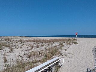
Poverty Beach or Sewell Point is a barrier spit, approximately 2.5 miles (4 km) in length entirely within the City of Cape May, along the Atlantic Ocean coast of eastern New Jersey in the United States. It is the southernmost barrier island in New Jersey.
Cape May Inlet is an inlet in southeastern Cape May County, New Jersey.

