
The Everglades is a natural region of tropical wetlands in the southern portion of the U.S. state of Florida, comprising the southern half of a large drainage basin within the Neotropical realm. The ecosystem it forms is not presently found anywhere else on earth. The system begins near Orlando with the Kissimmee River, which discharges into the vast but shallow Lake Okeechobee. Water leaving the lake in the wet season forms a slow-moving river 60 miles (97 km) wide and over 100 miles (160 km) long, flowing southward across a limestone shelf to Florida Bay at the southern end of the state. The Everglades experience a wide range of weather patterns, from frequent flooding in the wet season to drought in the dry season. Throughout the 20th century, the Everglades suffered significant loss of habitat and environmental degradation.
Eastern Air Lines, also colloquially known as Eastern, was a major American airline from 1926 to 1991. Before its dissolution, it was headquartered at Miami International Airport in an unincorporated area of Miami-Dade County, Florida.

Homestead is a city within Miami-Dade County in the U.S. state of Florida, between Biscayne National Park to the east and Everglades National Park to the west. Homestead is primarily a Miami suburb and a major agricultural area. It is a principal city of the Miami metropolitan area, which was home to an estimated 6,012,331 people at the 2015 census.
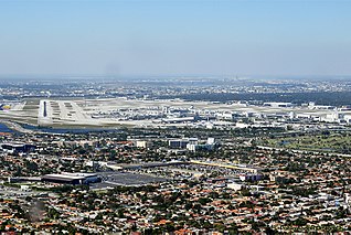
Miami International Airport, also known as MIA and historically as Wilcox Field, is the primary airport serving the Miami area, Florida, United States, with over 1,000 daily flights to 167 domestic and international destinations, including every country in Latin America, and one of three airports serving this area. The airport is in an unincorporated area in Miami-Dade County, 8 miles (13 km) northwest of Downtown Miami, in metropolitan Miami, adjacent to the cities of Miami and Miami Springs, and the village of Virginia Gardens. Nearby are the cities of Hialeah and Doral, and the Census-designated place of Fontainebleau.

Everglades National Park is an American national park that protects the southern twenty percent of the original Everglades in Florida. The park is the largest tropical wilderness in the United States and the largest wilderness of any kind east of the Mississippi River. An average of one million people visit the park each year. Everglades is the third-largest national park in the contiguous United States after Death Valley and Yellowstone. UNESCO declared the Everglades & Dry Tortugas Biosphere Reserve in 1976 and listed the park as a World Heritage Site in 1979, and the Ramsar Convention included the park on its list of Wetlands of International Importance in 1987. Everglades is one of only three locations in the world to appear on all three lists.
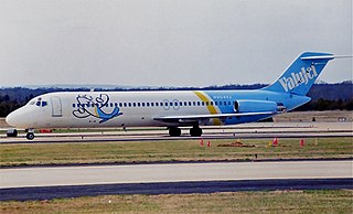
ValuJet Airlines Flight 592 was a regularly scheduled flight from Miami International Airport to Hartsfield–Jackson Atlanta International Airport. On May 11, 1996, the ValuJet Airlines McDonnell Douglas DC-9 operating the route crashed into the Everglades about 10 minutes after taking off from Miami as a result of a fire in the cargo compartment caused by improperly stored and labeled hazardous cargo. All 110 people on board died. The airline already had a poor safety record before the crash, and the accident brought widespread attention to the airline's problems. The airline was grounded for several months after the accident. When operations resumed, ValuJet was unable to attract the same amount of customers that it had before the accident. It acquired AirTran in 1997, but the lingering damage to the ValuJet name led ValuJet executives to assume the AirTran name.
The Tamiami Trail is the southernmost 275 miles (443 km) of U.S. Highway 41 (US 41) from Florida State Road 60 (SR 60) in Tampa to US 1 in Miami. A portion of the road also has the hidden designation of State Road 90 (SR 90).

The Arthur R. Marshall Loxahatchee National Wildlife Refuge is a 145,188-acre (587.55 km2) wildlife sanctuary is located west of Boynton Beach, in Palm Beach County, Florida. It is also known as Water Conservation Area 1 (WCA-1). It includes the most northern remnant of the historic Everglades wetland ecosystem.

ValuJet Airlines, later known as AirTran Airlines after joining forces with AirTran Airways, was an American ultra low-cost airline, headquartered in unincorporated Clayton County, Georgia, that operated regularly scheduled domestic and international flights in the Eastern United States and Canada during the 1990s. The company was founded in 1992 and was notorious for its sometimes dangerous cost-cutting measures. All of the airline's planes were purchased used from other airlines; very little training was provided to workers; and contractors were used for maintenance and other services. The company quickly developed a reputation for safety issues. In 1995, the military refused ValuJet's bid to fly military personnel over safety worries, and officials at the FAA wanted the airline to be grounded.
State Road 997, also known as Krome Avenue and West 177th Avenue is a 36.7-mile-long (59.1 km) north–south state highway in western Miami-Dade County, Florida. It runs from State Road 998 in Homestead north across U.S. Route 41 to U.S. Route 27 near Countyline Dragway, just south of the Broward County line. Its main use is as a bypass around the western side of Miami, linking the routes that run southwest, west and northwest from that city. The road passes through newer suburbs in the southern third of its length, while the northern two thirds of the highway traverse the eastern edge of the Everglades.

Dade-Collier Training and Transition Airport is a public airport located within the Florida Everglades, 36 miles (58 km) west of the central business district of Miami, in Collier County, Florida, United States. It is owned by Miami-Dade County and operated by the Miami-Dade Aviation Department. The airport is on the Tamiami Trail near the border between Dade and Collier counties in central South Florida.

A national push for expansion and progress toward the latter part of the 19th century stimulated interest in draining the Everglades, a region of tropical wetlands in southern Florida, for agricultural use. According to historians, "From the middle of the nineteenth century to the middle of the twentieth century, the United States went through a period in which wetland removal was not questioned. Indeed, it was considered the proper thing to do."

An ongoing effort to remedy damage inflicted during the 20th century on the Everglades, a region of tropical wetlands in southern Florida, is the most expensive and comprehensive environmental repair attempt in history. The degradation of the Everglades became an issue in the United States in the early 1970s after a proposal to construct an airport in the Big Cypress Swamp. Studies indicated the airport would have destroyed the ecosystem in South Florida and Everglades National Park. After decades of destructive practices, both state and federal agencies are looking for ways to balance the needs of the natural environment in South Florida with urban and agricultural centers that have recently and rapidly grown in and near the Everglades.

The effects of Climate change in Florida is attributable to man-made increases in atmospheric carbon dioxide. Floridians are experiencing increased flooding due to sea level rise, and are concerned about the possibility of more frequent or more intense hurricanes.

Miami-Dade County is a county located in the southeastern part of the U.S. state of Florida. According to the 2020 census, the county had a population of 2,701,767 making it the most populous county in Florida and the seventh-most populous county in the United States. It is also Florida's third largest county in terms of land area, with 1,946 square miles (5,040 km2). The county seat is Miami, the principal city in South Florida.

The Snapper Creek is a creek in the U.S. state of Florida that drains out of the Everglades into Biscayne Bay at Biscayne National Park. It is a 4-mile (6.4 km) long creek 15 miles (24 km) south of Downtown Miami, running through the suburbs of Kendall and Coral Gables in metropolitan Miami. The creek extends from Biscayne Bay inland to the Snapper Creek Canal, which extends 10 miles (16 km) further to the Everglades.

The Everglades Agricultural Area Environmental Protection District, better known as simply the Everglades Agricultural Area (EAA), is an area extending south from Lake Okeechobee to the northern levee of Water Conservation Area 3A, from its eastern boundary at the L-8 canal to the western boundary along the L-1, L-2, and L-3 levees. The EAA incorporates almost 3,000 square kilometers of highly productive agricultural land. The EAA was established by the State Legislature as a special district representing landowners within the EAA Basin for the purposes of ensuring environmental protection. Means include conducting scientific research on environmental matters related to air and water and land management practices and implementing the financing, construction, and operation of works and facilities designed to prevent, control, abate or correct environmental problems and improve the environmental quality of air and water resources.
The Everglades Protection Area is a protected area of the Florida Everglades as defined by the Everglades Forever Act, and includes Water Conservation Area 1, Water Conservation Area 2, made up of WCA-2a and WCA-2b, Water Conservation Area 3, made up of WCA-3a and WCA-3b, and the Everglades National Park.
The Everglades Nutrient Removal Project (ENRP) was a demonstration-scale wetland project proposed by the Everglades Forever Act. Functioning as a prototype for the much larger scale Everglades Construction Project, the ENRP was designed to model the process of using Stormwater treatment areas (STAs) to remove nutrients, especially phosphorus, from agricultural runoff entering the Everglades.

