
Avon Water, also known locally as the River Avon, is a 24-mile-long (39 km) river in Scotland, and a tributary of the River Clyde.

Santa Monica Bay is a bight of the Pacific Ocean in Southern California, United States. Its boundaries are slightly ambiguous, but it is generally considered to be the part of the Pacific within an imaginary line drawn between Point Dume, in Malibu, and the Palos Verdes Peninsula. Its eastern shore forms the western boundary of the Los Angeles Westside and South Bay regions. Although it was fed by the Los Angeles River until the river's catastrophic change of course in 1825, the only stream of any size now flowing into it is Ballona Creek. Smaller waterways draining into the bay include Malibu Creek, Topanga Creek, and Santa Monica Creek.

Kyle is a former comital district of Scotland which stretched across parts of modern-day East Ayrshire and South Ayrshire. It is supposedly named after Coel Hen, a legendary king of the Britons, who is said to be buried under a mound at Coylton.

The River Ayr is a river in Ayrshire, Scotland. At 65 km (40 mi) it is the longest river in the county.

The River Doon is a river in Ayrshire, Scotland. Its course is generally north-westerly, passing near to the town of Dalmellington, and through the villages of Patna, Dalrymple, and Alloway, birthplace of Robert Burns. The source of the Doon is Loch Doon, high in the Galloway Hills.

The River Garnock, the smallest of Ayrshire's six principal rivers, has its source on the southerly side of the Hill of Stake in the heart of the Clyde Muirshiel Regional Park. About a mile and a half south of this starting point the untested stream tumbles over the Spout of Garnock, the highest waterfall in Ayrshire, once thought to be the river's origin. The river then continues, for a total length of 20 miles (32 km) or so, through the towns of Kilbirnie, Glengarnock, Dalry and Kilwinning to its confluence with the River Irvine at Irvine Harbour.

Red Oak Creek or Bullock Creek is a 35 miles (56 km) stream and tributary of the Trinity River in North Texas.
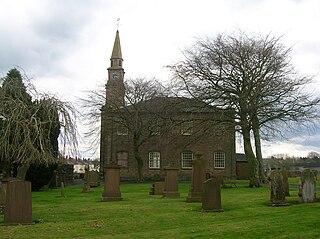
Tarbolton is a village in South Ayrshire, Scotland. It is near Failford, Mauchline, Ayr, and Kilmarnock. The old Fail Monastery was nearby and Robert Burns connections are strong, including the Bachelors' Club museum.

Tarbolton railway station was a railway station about a mile and a quarter from the village of Tarbolton that it served, in South Ayrshire, Scotland. The station was part of the Ayr to Mauchline Branch of the Glasgow and South Western Railway and was the only intermediate stop on the previously double track line between Annbank and Mauchline. The line was singled in 1985 and held in reserved state before reopening with an increase in coal traffic.
The Irvine New Town Trail is a recreational cycleway and footpath around Irvine, North Ayrshire, Scotland. The route is 19 kilometres (12 mi) long. The trail is used by many dog walkers and cyclists in the area.
A moot hill or mons placiti is a hill or mound historically used as an assembly or meeting place, as a moot hall is a meeting or assembly building, also traditionally to decide local issues. In early medieval Britain, such hills were used for "moots", meetings of local people to settle local business. Among other things, proclamations might be read; decisions might be taken; court cases might be settled at a moot. Although some moot hills were naturally occurring features or had been created long before as burial mounds, others were purpose-built.

The Water of Girvan is a river in South Ayrshire, which has its source at Loch Girvan Eye in the Carrick Forest section of Galloway Forest Park. This 28-mile (45-kilometre) river passes through the villages of Straiton, Crosshill and Dailly en route to the Firth of Clyde at Girvan Harbour.

The Fushui River (富水) is a river flowing through Tongshan and Yangxin Counties in the south-eastern part of Hubei province, China.
Failford is a hamlet in South Ayrshire, Scotland. It is 4 kilometres (2.5 mi) west of Mauchline, where the Water of Fail flows into the River Ayr.

Fail Monastery, occasionally known as Failford Abbey, had a dedication to 'Saint Mary', and was located at Fail on the bank of the Water of Fail, Parish of Tarbolton near the village of Tarbolton, South Ayrshire. Most of the remaining monastery ruins were removed in 1952. The official and rarely used title was House of the Holy Trinity of Failford or the Ministry of Failford.

Barnweill Church or Barnweil Church is a ruined pre-reformation kirk situated on rising ground on the slopes of Barnweill Hill, Parish of Craigie, South Ayrshire, Scotland; about 3 km from Tarbolton. The church was known locally as the "Kirk in the Wood". It lies about 170m North North-East of Kirkhill Farm. Barnweill was central to the Protestant Reformation in Ayrshire through its association with John Knox. The spelling 'Barnweill' is used throughout for consistency.
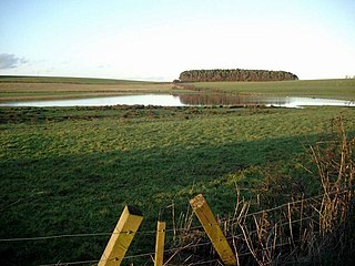
Lochlea or Lochlie was situated in a low-lying area between the farms and dwellings of Lochlea and Lochside in the Parish of Tarbolton, South Ayrshire, Scotland. The loch was natural, sitting in a hollow created by glaciation. The loch waters ultimately drained via Fail Loch, the Mill Burn, and the Water of Fail. It is well-documented due to the presence of a crannog that was excavated and documented circa 1878, and its association with the poet Robert Burns, who lived here for several years whilst his father was the tenant. Lochlea lies 2+1⁄2 miles northeast of Tarbolton, and just over three miles northwest of Mauchline.

Fail Loch or Faile Loch was situated in a low-lying area near the old monastery of Fail in the Parish of Tarbolton, South Ayrshire, Scotland. The old Lochlea Loch lies nearby and its waters still feed into Fail Loch via the Mill Burn.

Wallace's Heel Well or Wallace's Heel is located beside the River Ayr (NS35502122) near the old Holmston lime kiln, Ayr, Scotland. It is a petrosomatoglyph said to represent the imprint of a heel and is associated with the story of an escape from English soldiers made by the Scottish hero William Wallace.