This page is based on this
Wikipedia article Text is available under the
CC BY-SA 4.0 license; additional terms may apply.
Images, videos and audio are available under their respective licenses.

South Africa occupies the southern tip of Africa, its coastline stretching more than 2,850 kilometres from the desert border with Namibia on the Atlantic (western) coast southwards around the tip of Africa and then northeast to the border with Mozambique on the Indian Ocean. The low-lying coastal zone is narrow for much of that distance, soon giving way to a mountainous escarpment that separates the coast from the high inland plateau. In some places, notably the province of KwaZulu-Natal in the east, a greater distance separates the coast from the escarpment. Although most of the country is classified as semi-arid, it has considerable variation in climate as well as topography.

The Herero Wars were a series of colonial wars between the German Empire and the Herero people of German South West Africa.

The Bradfield's hornbill is an African hornbill. It is a medium-sized bird, 50–57 centimetres (20–22 in) in length, characterized by black back and wings and a white belly. The tip feathers of the long tail are white. Females are smaller than males and can be recognized by turquoise facial skin. The eyes are yellow and the beak is red. The beak is long and presents no casque.

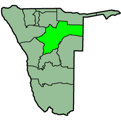
Otjiwarongo is a city of 28,000 inhabitants in the Otjozondjupa Region of Namibia. It is the district capital of the Otjiwarongo electoral constituency and also the capital of Otjozondjupa.

Samuel Maharero was a Paramount Chief of the Herero people in German South West Africa during their revolts and in connection with the events surrounding the Herero genocide. Today he is considered a national hero in Namibia.

Waterberg Plateau Park is a national park in central Namibia on the Waterberg Plateau, 68 kilometres (42 mi) south-east of Otjiwarongo. The plateau and the national park are named after the prominent table mountain that rises from the plateau, the Waterberg. The Waterberg Plateau is a particularly prominent location, elevating high above the plains of the Kalahari of Eastern Namibia. Waterberg Park and some 405 square kilometres (156 sq mi) of surrounding land were declared a Nature Reserve in 1972. As the plateau is largely inaccessible from beneath several of Namibia's endangered species were relocated in the early 1970s to protect them from predators and poaching to extinction. The programme was very successful and Waterberg now supplies other Namibian parks with rare animals. In 1989, the black rhinoceros was reintroduced to the area from Damaraland.

The Battle of Waterberg took place on August 11, 1904 at the Waterberg, German South West Africa, and was the decisive battle in the German campaign against the Herero.
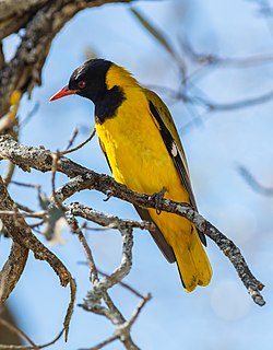
The black-headed oriole is a species of bird in the family Oriolidae. It is found in Africa and has a very striking appearance with a bright yellow body, contrasting black head and flesh-coloured beak.

The wildlife of Namibia is composed of its flora and fauna. Namibia's endangered species include wild dog, black rhino, oribi and puku.

Tourism in Namibia is a major industry, contributing N$7.2 billion to the country's gross domestic product. Annually, over one million travelers visit Namibia, with roughly one in three coming from South Africa, then Germany and finally the United Kingdom, Italy and France. The country is among the prime destinations in Africa and is known for ecotourism which features Namibia's extensive wildlife.

Chief Hosea Komombumbi Kutako, was an early Namibian nationalist leader and a founder member of Namibia's first nationalist party, the South West African National Union (SWANU).

Herero Day is a gathering of the Herero people of Namibia to commemorate their deceased chieftains. It is held in Okahandja in central Namibia annually on August 26, the day and place Herero chief Samuel Maharero's body was reburied alongside his ancestors in 1923. Accordingly, the celebrations last three days long, although they usually begin on the Sunday nearest the 23rd.
Heroes' Day is a national public holiday in Namibia. It is recognized by the United Nations as Namibia Day. Celebrated annually on 26 August, the day commemorates the Namibian War of Independence which began on 26 August 1966 at Omugulugwombashe.

German South West Africa was a colony of the German Empire from 1884 until 1919. With an area of 835,100 km², it was one and a half times the size of the mainland German Empire in Europe at the time. The colony had a population of around 2,600 Germans.

Rooiberg is a town in Waterberg District Municipality in the Limpopo province of South Africa.

The Omingonde Formation is an Early to Middle Triassic geologic formation, part of the Karoo Supergroup, in the western Otjozondjupa Region and northeastern Erongo Region of north-central Namibia. The formation has a maximum thickness of about 600 metres (2,000 ft) and comprises sandstones, shales, siltstones and conglomerates, was deposited in a fluvial environment, alternating between a meandering and braided river setting.