Gallery
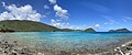 Waterlemon Bay and Cay
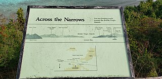
 Map of Leinster Bay trail
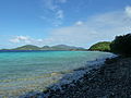 View from Leinster Bay trail, including Waterlemon Cay
 Leinster Bay
 Turtle near Waterlemon Cay
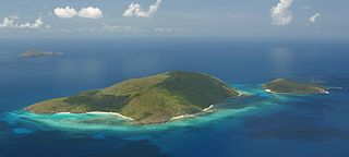
Waterlemon Cay is a small cay surrounded by a fringing reef located in Leinster Bay on Saint John, U.S. Virgin Islands. It is named after the water lemon.
The cay is surrounded by a fringing reef, and is considered to be one of the best snorkeling spots on the island. [1] A trail leads from the sandy beach at Leinster Bay approximately 1 km (0.62 mi) along the point, from which is a ten-minute swim to the cay, where there is a small beach. The cay boasts a wide variety of reef fishes and coral; however, bleaching is prevalent, and the marine life has decreased in recent times. Many attribute the depletion of Coral reefs of the Virgin Islands to high rates of erosion and runoff caused by the construction boom on the Islands.
Local lore states that when dueling was outlawed in the Danish West Indies, the remote strip of sand on Waterlemon Cay became the preferred spot to engage in combat.


The United States Virgin Islands are a group of several dozen islands and cays located in the Caribbean, about 1,100 miles (1,770 km) southeast of Florida, 600 miles (966 km) north of Venezuela, 40 miles (64 km) east of Puerto Rico, and immediately west and south of the British Virgin Islands.

Fitzroy Island National Park is a gazetted protected area covering Fitzroy Island, in Far North Queensland, Queensland, Australia. Fitzroy Island, is a continental island located 22 kilometres (14 mi) east of Cairns on the mainland.

A cay, also spelled caye or key, is a small, low-elevation, sandy island on the surface of a coral reef. Cays occur in tropical environments throughout the Pacific, Atlantic, and Indian oceans, including in the Caribbean and on the Great Barrier Reef and Belize Barrier Reef.

The Virgin Islands National Park is an American national park preserving about 60% of the land area of Saint John in the United States Virgin Islands, as well as more than 5,500 acres of adjacent ocean, and nearly all of Hassel Island, just off the Charlotte Amalie, Saint Thomas harbor.

Buck Island Reef National Monument protects Buck Island, a small, uninhabited 176-acre island about 1.5 miles (2.4 km) north of the northeast coast of Saint Croix, U.S. Virgin Islands, and 18,839 acres of submerged lands, totaling 19,015 acres. It was first established as a protected area by the U.S. Government in 1948, with the intention of preserving “one of the finest marine gardens in the Caribbean Sea.” The U.S. National Monument was created in 1961 by John F. Kennedy and greatly expanded in 2001 by Bill Clinton, over the opposition of local fishermen. Buck Island National Monument is one of few places in the Virgin Islands where brown pelicans and threatened least terns nest.

Saint John is one of the Virgin Islands in the Caribbean Sea and a constituent district of the United States Virgin Islands (USVI), an unincorporated territory of the United States.
Trunk Bay is a body of water and a beach on St. John in the United States Virgin Islands. Trunk Bay is part of the Virgin Islands National Park. Trunk Bay is named for the Leatherback turtle, which is endemic to the USVI and are locally known as trunks. The beach area is divided into two halves, the main Trunk Bay beach and swim area and Burgesman Cove which is located on the west end of Trunk Bay near Jumby Bay. Its amenities include a snack bar, showers and restrooms, a lifeguard, and an underwater trail for snorkeling its coral reef. Trunk Bay has consistently been voted one of the top beaches in the world.

Cinnamon Bay is a body of water and a beach on St. John island, within Virgin Islands National Park, in the United States Virgin Islands.
The Hans Lollik Islands are two islands in the U.S. Virgin Islands owned by Larry Page. In 2014, Page bought Great Hans Lollik Island ("GHL") and its smaller neighbor, Little Hans Lollik, for $23 million.

Scrub Island of the British Virgin Islands in the Caribbean is a part of the Lesser Antilles, a group of islands that are young volcanic or coral islands. It is home to the Scrub Island Resort Marina and Spa.

Gibney Beach, or Oppenheimer Beach, is a beach on Hawksnest Bay on northern Saint John in the United States Virgin Islands. The beach's names originate from Nancy Flagg Gibney and J. Robert Oppenheimer and their families, the owners of the beach in the mid-20th century. The beach has been mostly accessible to the public since its acquisition, and a community center has been created on the property, where Oppenheimer’s house used to be.
Congo Cay is an uninhabited island of the United States Virgin Islands, located north of Lovango Cay. It is a snorkeling spot for charter boats from Saint Thomas and Saint John. Congo Cay in the US Virgin Islands is owned by the local government. As pretty much almost all of the smaller islands, islets and cays in the USVI, Congo Cay in the US Virgin Islands is a wild life refuge. It is one of the most beautiful non inhabited cays in the Virgin Islands and a nesting habitat for pelicans.

Lovango Cay is a private island in the district of St. John, in the United States Virgin Islands.
Tryon Island is a coral cay located in the southern Great Barrier Reef, 86 km northeast of Gladstone, Queensland, Australia, and 465 km north of the state capital Brisbane. The island is a protected area and forms part of Capricornia Cays National Park. It is part of the Capricornia Cays Important Bird Area. The cay covers an area of 0.21 square kilometres and is surrounded by a coral reef that is partially exposed at low-tide.
Leinster Bay is a bay and former sugar cane plantation on the island of Saint John in the United States Virgin Islands. It is uninhabited and part of Virgin Islands National Park. Visitors can park at Annaberg and hike the Leinster Bay trail to access the bay, which is a popular snorkeling spot. Waterlemon Cay is a small cay in Leinster Bay. The ruins of the plantation's estate house can be reached by continuing past the bay and up the Johnny Horn Trail.

The fauna of the United States Virgin Islands consists of 144 species of birds, 22 species of mammals, 302 species of fish and 7 species of amphibians. The wildlife of the U.S.V.I. includes numerous endemic species of tropical birds, fish, and land reptiles as well as sea mammals. The only endemic land mammals are six species of native bats: the greater bulldog bat, Antillean fruit-eating bat, red fruit bat, Brazilian free-tailed bat, velvety free-tailed bat and the Jamaican fruit bat. Some of the nonnative land mammals roaming the islands are the white-tailed deer, small Asian mongoose, goats, feral donkeys, rats, mice, sheep, hogs, dogs and cats.

East End is an administrative subdistrict of the island of St. Thomas in the United States Virgin Islands. The largest community is Red Hook, while smaller communities include Benner, Nazareth, Nadir, Frydendal, and Smith Bay. The subdistrict includes the offshore islands of Great Saint James, Little Saint James, Bovoni Cay, Patricia Cay, Cas Cay, Rotto Cay, Thatch Cay, Shark Island, and Dog Island.
The St. Croix East End Marine Park (STXEEMP) was established to "protect territorially significant marine resources, and promote sustainability of marine ecosystems, including coral reefs, sea grass beds, wildlife habitats and other resources, and to conserve and preserve significant natural areas for the use and benefit of future generations." It is the U.S. Virgin Islands’ first territorially designated and managed marine protected area (MPA).
Oil Nut Bay is a coral reef bay situated on the northeast coast of Virgin Gorda in the British Virgin Islands, about 1 kilometre (0.62 mi) west of Pajaros Point.

One of the marine ecosystems found in the Virgin Islands are the coral reefs. These coral reefs can be located between the islands of St. Croix, St. Thomas, and St. John. These coral reefs have an area of 297.9 km2, along with other marine habitats that are in between. The way these coral reefs grow are by coral larvae swimming freely and attaching themselves to hard surfaces around the islands and start to develop a skeleton on the outside of their skin to protect themselves from predators but also allow a new place for other coral larvae to attach to and grow on. These corals can form into three different structures; fringing reefs, which are reefs that are close to the shore, barrier reefs, which are reefs that are alongside the shore and is separated by deep water, and an atoll reef which is a coral reef that circles a lagoon or body of water.
18°22′01″N64°43′24″W / 18.36694°N 64.72333°W
| | This Saint John, United States Virgin Islands location article is a stub. You can help Wikipedia by expanding it. |