External links
| Wikimedia Commons has media related to Waternish Point . |
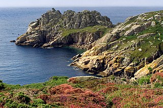
Waternish or Vaternish Point (Scottish Gaelic Rubha Bhatairnis) is the northwestern promontory of the Waternish peninsula on Skye. Its chief feature is the steep cliff above a rocky beach. Above the cliff grassy terrain rises gently to the abandoned settlement of Unish, now only ruins. The grassland over the point is considered part of the point. It was once farmed from Unish.
Waternish Point has housed the Vaternish Lighthouse since 1924.
Vaternish Point is a rugged, uncultivated high promontory. [1]
| Wikimedia Commons has media related to Waternish Point . |

The Mull of Kintyre is the southwesternmost tip of the Kintyre Peninsula in southwest Scotland. From here, the Antrim coast of Northern Ireland is visible on a calm and clear day, and a historic lighthouse, the second commissioned in Scotland, guides shipping in the intervening North Channel. The area has been immortalised in popular culture by the 1977 hit song "Mull of Kintyre" by Kintyre resident Paul McCartney's band of the time, Wings.

A promontory fort is a defensive structure located above a steep cliff, often only connected to the mainland by a small neck of land, thus using the topography to reduce the ramparts needed. Although their dating is problematic, most seem to date to the Iron Age. They are mainly found in Brittany, Ireland, the Orkney Islands, the Isle of Man, Devon and Cornwall.

Siccar Point is a rocky promontory in the county of Berwickshire on the east coast of Scotland. It is famous in the history of geology for Hutton's Unconformity found in 1788, which James Hutton regarded as conclusive proof of his uniformitarian theory of geological development.

Cave Hill or Cavehill is a rocky hill overlooking the city of Belfast, Northern Ireland, with a height of 368 metres (1,207 ft). It is marked by basalt cliffs and caves, and its distinguishing feature is 'Napoleon's Nose', a tall cliff which resembles the profile of the emperor Napoleon. On top of this are the remains of an ancient promontory fort called McArt's Fort. Cavehill was also historically called 'Ben Madigan', after a king of Ulster called Madagán who died in 856AD.

The Illawarra escarpment, or officially the Illawarra Range, is the fold-created cliffs and plateau-eroded outcrop mountain range west of the Illawarra coastal plain south of Sydney, in the state of New South Wales, Australia. The range encloses the Illawarra region which stretches from Stanwell Park in the north to Kiama, Gerringong and the Shoalhaven River in the south.
Treryn Dinas is a headland near Treen, on the Penwith peninsula between Penberth Cove and Porthcurno in Cornwall, England.

Rusk Mountain is a peak located in the towns of Jewett and Lexington in Greene County, New York, United States. At 3,680 feet in elevation, it is the 20th-highest peak in the Catskill Mountains and considered a member of the Catskill High Peaks. While there is no maintained trail, a bushwhack to the summit is considered relatively easy, and required for membership in the Catskill Mountain 3500 Club.

Point Dume is a promontory on the coast of Malibu, California that juts out into the Pacific Ocean. The point, a long bluff, forms the northern end of the Santa Monica Bay. Point Dume Natural Area affords a vista of the Palos Verdes Peninsula and Santa Catalina Island. Zuma Beach lies to its immediate northwest.

Mingay is an islet in the Inner Hebrides off Skye and Isay.

Clett is a name used for many uninhabited Scottish islets and one to the south, though also in the area inhabited by Vikings. They include -

Waternish or Vaternish is a peninsula approximately 12 kilometres long on the island of Skye, Scotland, situated between Loch Dunvegan and Loch Snizort in the northwest of the island, and originally inhabited and owned by Clan MacNeacail/MacNicol/Nicolsons.

Gillen is a hamlet on the Waternish peninsula of the island of Skye in the Scottish council area of Highland.
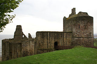
Ravenscraig Castle is a ruined castle located in Kirkcaldy which dates from around 1460. The castle is an early example of artillery defence in Scotland.
Claigan is a small coastal settlement on the north east shore of the sea loch, Loch Dunvegan, on the Waternish peninsula, in north western Isle of Skye, Scottish Highlands and is in the Scottish council area of Highland. The village of Dunvegan lies approximately 4 miles southeast, at the base of the loch.

The Isle of Skye, or simply Skye, is the largest and northernmost of the major islands in the Inner Hebrides of Scotland. The island's peninsulas radiate from a mountainous hub dominated by the Cuillin, the rocky slopes of which provide some of the most dramatic mountain scenery in the country. Although Sgitheanach has been suggested to describe a winged shape, no definitive agreement exists as to the name's origins.
Duirinish is a peninsula on the island of Skye in Scotland. It is situated in the north west between Loch Dunvegan and Loch Bracadale.

Cornish promontory forts, commonly known in Cornwall as cliff castles, are coastal equivalents of the hill forts and Cornish "rounds" found on Cornish hilltops and slopes. Similar coastal forts are found on the north–west European seaboard, in Normandy, Brittany and around the coastlines of the British Isles, especially in Wales, Scotland and Ireland. Many are known in southwest England, particularly in Cornwall and its neighbouring county, Devon. Two have been identified immediately west of Cornwall, in the Isles of Scilly.

Crosskirk Broch was a fortification near the present day hamlet of Crosskirk near Thurso, Caithness, Scotland. After thorough archaeological exploration it was destroyed in 1972 since the site had become unsafe due to sea erosion. The site was unusual in having a broch, a large circular fortification, built within an older promontory fortification with a ring wall and blockhouse.

The Ness of Burgi fort is an iron-age promontory fort in the Old Scatness archaeological site on the Ness of Burgi, a narrow finger of land reaching south from the Scat Ness in the far south of the island of Mainland, Shetland in Scotland.

The Broch of Borwick is an Iron Age broch located on Mainland, Orkney, Scotland. It is a scheduled monument.