
Lombok is an island in West Nusa Tenggara province, Indonesia. It forms part of the chain of the Lesser Sunda Islands, with the Lombok Strait separating it from Bali to the west and the Alas Strait between it and Sumbawa to the east. It is roughly circular, with a "tail" to the southwest, about 70 kilometres across and a total area of about 4,738.65 square kilometres including smaller offshore islands. The provincial capital and largest city on the island is Mataram.
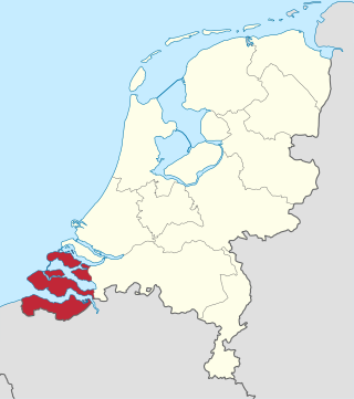
Zeeland is the westernmost and least populous province of the Netherlands. The province, located in the southwest of the country, borders North Brabant to the east, South Holland to the north, as well as the country of Belgium to the south and west. It consists of a number of islands and peninsulas and a strip bordering the Flemish provinces of East and West Flanders. Its capital is Middelburg with a population of 48,544 as of November 2019, although the largest municipality in Zeeland is Terneuzen. Zeeland has two seaports: Vlissingen and Terneuzen. Its area is 2,934 square kilometres (1,130 sq mi), of which 1,151 square kilometres (440 sq mi) is water; it has a population of 383,689.
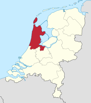
North Holland is a province of the Netherlands in the northwestern part of the country. It is located on the North Sea, north of South Holland and Utrecht, and west of Friesland and Flevoland. As of January 2023, it had a population of about 2,952,000 and a total area of 4,092 km2 (1,580 sq mi), of which 1,429 km2 (552 sq mi) is water.

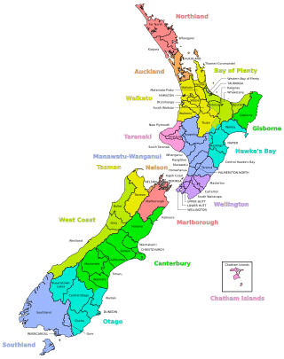
New Zealand is divided into sixteen regions for local government purposes. Eleven are administered by regional councils, and five are administered by unitary authorities, which are territorial authorities that also perform the functions of regional councils. The Chatham Islands Council is not a region but is similar to a unitary authority, authorised under its own legislation.

Territorial authorities are the second tier of local government in New Zealand, below regional councils. There are 67 territorial authorities: 13 city councils, 53 district councils and the Chatham Islands Council. District councils serve a combination of rural and urban communities, while city councils administer the larger urban areas. Five territorial authorities also perform the functions of a regional council and thus are unitary authorities. The Chatham Islands Council is a sui generis territorial authority that is similar to a unitary authority.
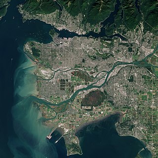
The Metro Vancouver Regional District (MVRD), or simply Metro Vancouver, is a Canadian political subdivision and corporate entity representing the metropolitan area of Greater Vancouver, designated by provincial legislation as one of the 28 regional districts in British Columbia. The organization was known as the Regional District of Fraser–Burrard for nearly one year upon incorporating in 1967, and as the Greater Vancouver Regional District (GVRD) from 1968 to 2017.
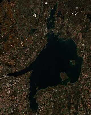
Lake Simcoe is a lake in southern Ontario, Canada, the fourth-largest lake wholly in the province, after Lake Nipigon, Lac Seul, and Lake Nipissing. At the time of the first European contact in the 17th century, the lake was called Ouentironk by the native Wendat/Ouendat (Huron) people. It was also known as Lake Taronto until it was renamed by John Graves Simcoe, the first Lieutenant-Governor of Upper Canada, in memory of his father, Captain John Simcoe of the Royal Navy. In Anishinaabemowin, the historical language of the First Nations living around this lake, namely Anishinaabek of Rama and Georgina Island First Nations, the lake is called Zhooniyaang-zaaga'igan, meaning "Silver Lake".

The Riau Islands is a province of Indonesia - not to be confused with neighbouring Riau Province from which the islands were separated in 2002. The capital of the province is Tanjung Pinang and the largest city is Batam. It shares a maritime border with Riau and Jambi to the east, Bangka Belitung Islands to the south, Singapore to the northeast, Malaysia and West Kalimantan to the west, and Vietnam and Cambodia to the north. It comprises a total of 1,796 islands scattered between Sumatra, Malay Peninsula, and Borneo including the Riau Archipelago. Situated on one of the world's busiest shipping lanes along the Malacca Strait and the Natuna Sea, the province shares water borders with neighboring countries such as Singapore, Malaysia, and Brunei. The Riau Islands also have relatively large potential mineral resources and energy, as well as marine resources.
The Netherlands has several levels of administrative subdivisions. The first level of subdivision consists of 12 provinces. The second level of subdivision consists of 342 municipalities.

Regional parks of New Zealand are protected areas administered by regional councils, the top tier of local government. Regional parks are found across five regions of New Zealand: the Auckland Region, Waikato Region, Bay of Plenty Region, Wellington Region and Canterbury Region. Regional parks in the Auckland and Waikato regions are administered by the Auckland Council, while parks in other areas are administered by regional councils: the Bay of Plenty Regional Council, Greater Wellington Regional Council, and Canterbury Regional Council.

San Francisco Bay Ferry is a public transit passenger ferry service in the San Francisco Bay, administered by the San Francisco Bay Area Water Emergency Transportation Authority (WETA) and operated under contract by the privately owned, Blue and Gold Fleet. In 2022, the system had a ridership of 1,787,400, or about 10,400 per weekday as of the third quarter of 2023.

Environment Canterbury, frequently abbreviated to ECan, is the promotional name for the Canterbury Regional Council. It is the regional council for Canterbury, the largest region in the South Island of New Zealand. It is part of New Zealand's structure of local government.
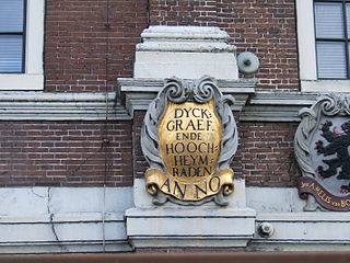
In the Netherlands, a water board, water council or water authority is a regional governing body solely charged with the management of surface water in the environment. Water boards are independent of administrative governing bodies like provinces and municipalities. In general, they are responsible for managing rivers and canals, issues with the flow of watercourses and drainage issues, water collection, flood and erosion prevention and provision of potable water. They manage polder systems, water levels, water barriers and locks, enforcements, water quality and sewage treatment in their respective regions. The concept of a coordinating "High Water Authority" (Hoogheemraadschap) originated in what now is the province of South Holland in the 12th century.

The Endeavour Strait is a strait running between the Australian mainland Cape York Peninsula and Prince of Wales Island in the extreme south of the Torres Strait, in northern Queensland, Australia. It was named in 1770 by explorer James Cook, after his own vessel, HMS Endeavour, and he used the strait as passage out to the Indian Ocean on his voyage.

The Caribbean or West Indies is a subregion of the Americas that includes the Caribbean Sea and its islands, some of which are surrounded by the Caribbean Sea and some of which border both the Caribbean Sea and the North Atlantic Ocean; the nearby coastal areas on the mainland are often also included in the region. The region is southeast of the Gulf of Mexico and the North American mainland, east of Central America, and north of South America.
A district in New Zealand is a territorial authority area governed by a district council as a second-tier of local government in New Zealand, below regional councils. They were formed as a result of the local government reforms in 1989. There are 53 districts in New Zealand, and they do not include the 12 city councils, the Auckland Council, and the Chatham Islands Council. District councils serve a combination of rural and urban communities, while city councils administer the larger urban areas. Three districts are unitary authorities also performing the functions of a regional council.
Wenderholm Regional Park is a regional park north of Auckland in New Zealand's North Island. It is situated between the estuaries of the Puhoi River and the Waiwera River, on the east coast of New Zealand's North Island and features a homestead known as Couldrey House, and a carved pouwhenua.
Eastern Visayas is an administrative region in the Philippines, designated as Region VIII. It consists of three main islands, Samar, Leyte and Biliran. The region has six provinces, one independent city and one highly urbanized city namely, Biliran, Leyte, Northern Samar, Samar, Eastern Samar, Southern Leyte, Ormoc and Tacloban. The highly urbanized city of Tacloban is the sole regional center. These provinces and cities occupy the easternmost islands of the Visayas group of islands.

Waharau Regional Park is a regional park situated in the Hauraki District and the Waikato Region of New Zealand's North Island, four kilometres north of Whakatīwai Regional Park. It is just south of the border with the Auckland Region, and is owned and operated by Auckland Council. It runs from the eastern side of the Hunua Ranges, where it adjoins Hunua Ranges Regional Park, down to the Firth of Thames coast.

