
Bethnal Green is an area in London, England and is located in the London Borough of Tower Hamlets. It is in east London and part of the East End. The area emerged from the small settlement which developed around the Green, much of which survives today as Bethnal Green Gardens, beside Cambridge Heath Road. By the 16th century the term applied to a wider rural area, the Hamlet of Bethnal Green, which subsequently became a Parish, then a Metropolitan Borough before merging with neighbouring areas to become the north-western part of the new Tower Hamlets.

Poplar is a district in East London, England and is in the London Borough of Tower Hamlets. It is an inner-city suburb located five miles (8 km) east of Charing Cross and lays on the western bank of the River Lea and is part of the London Docklands.

Stepney is an area in London, England and is located in the London Borough of Tower Hamlets. It is in East London and part of the East End. Stepney is no longer officially defined, and is usually used to refer to a relatively small area. However, for much of its history the place name applied to a much larger manor and parish. Stepney Green is a remnant of a larger area of Common Land formerly known as Mile End Green.

Wapping is an area in London, England and is located in the London Borough of Tower Hamlets. It is in East London and part of the East End. Wapping is on the north bank of the River Thames between St Katharine Docks to the west, and Shadwell to the east. This position gives the district a strong maritime character.

The London Borough of Tower Hamlets is a borough of London, England. Situated on the north bank of the River Thames and immediately east of the City of London, the borough spans much of the traditional East End of London and includes much of the regenerated London Docklands area. The 2019 mid-year population for the borough is estimated at 324,745.

Shadwell is an area in London, England and is located in the London Borough of Tower Hamlets. It is in East London and part of the East End. Shadwell is on the north bank of the River Thames between Wapping and Ratcliff and Limehouse and is 3 miles (4.8 km) east of Charing Cross. This riverside location has meant the area's history and character have been shaped by the maritime trades.

Chrisp Street Market is the central marketplace and town centre of Poplar and is located in the London Borough of Tower Hamlets. It was the first purpose-built pedestrian shopping area in the United Kingdom, rebuilt as part of the 1951 Festival of Britain and is directly connected onto the high street, East India Dock Road.

Ratcliff or Ratcliffe is a locality in the London Borough of Tower Hamlets. It lies on the north bank of the River Thames between Limehouse, and Shadwell. The place name is no longer commonly used.

The Camden markets are a number of adjoining large retail markets, often collectively referred to as Camden Market or Camden Lock, located in the historic former Pickfords stables, in Camden Town, London. It is situated north of the Hampstead Road Lock of the Regent's Canal. Famed for their cosmopolitan image, products sold on the stalls include crafts, clothing, bric-a-brac, and fast food. It is the fourth-most popular visitor attraction in London, attracting approximately 250,000 people each week.
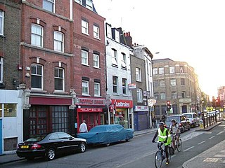
Cable Street is a road in the East End of London, England, with several historic landmarks nearby. It was made famous by the Battle of Cable Street in 1936.

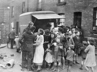
The Birmingham Blitz was the heavy bombing by the Nazi German Luftwaffe of the city of Birmingham and surrounding towns in central England, beginning on 9 August 1940 as a fraction of the greater Blitz, which was part of the Battle of Britain; and ending on 23 April 1943. Situated in the Midlands, Birmingham, the most populous British city outside London, was considered an important industrial and manufacturing location. Around 1,852 tons of bombs were dropped on Birmingham, making it the third most heavily bombed city in the United Kingdom in the Second World War, behind London and Liverpool.

Exmouth Market is a semi-pedestrianised street in Clerkenwell in the London Borough of Islington, and the location of an outdoor street market of 32 stalls.

The Moor Quarter is one of Sheffield's twelve designated quarters, built around and named for The Moor, a pedestrianised thoroughfare. It is bound by Furnival Gate in the north-east, Eyre Street in the south-east, St Mary's Gate to the south, and Moore Street and Charter Row to the north-west.
Altab Ali was a Bangladeshi textile worker stabbed to death in London, in a racially motivated killing. His death sparked widespread outrage and grassroots action that helped to reduce racism against British Bangladeshis and British Asians in the United Kingdom.
The Swansea Blitz was the heavy and sustained bombing of Swansea by the German Luftwaffe from 19 to 21 February 1941. A total of 230 people were killed and 397 were injured. Swansea was selected by the Germans as a legitimate strategic target due to its importance as a port and docks and the oil refinery just beyond, and its destruction was key to Nazi German war efforts as part of their strategic bombing campaign aimed at crippling coal export and demoralizing civilians and emergency services.

Queen's Crescent Market is an outdoor street market held every Thursday and Saturday on Queen's Crescent in Kentish Town, Camden between the junction with Malden Road in the West and the junction with Grafton Road in the East. Licences to trade are issued by Camden London Borough Council.

St George in the East, historically known as Wapping-Stepney, was an ancient parish, in the London Borough of Tower Hamlets, England. The place name is no longer widely used.

Whitechapel Road market, also known as Whitechapel Market is a long-established historic London outdoor street market managed by the London Borough of Tower Hamlets which is centered on the A11 thoroughfare of the same name in Whitechapel in the East End of London, next to Whitechapel station and is the focus point of the Whitechapel Market Conservation Area that was set up in 1997 and extended in 2008.

Mayflower Primary School is a primary school in the Poplar area of East London in the London Borough of Tower Hamlets. Originating in 1843 and formerly called Upper North Street School, it was badly damaged in an air raid in 1917 during the First World War, resulting in the deaths of eighteen children. The school was rebuilt in 1928 and adopted its present name in 1952. The school was judged to be "outstanding" at an Ofsted inspection in 2017, and was awarded the title "Primary School of the Year" in 2020 by a national newspaper.

The 2022 Tower Hamlets London Borough Council election took place on 5 May 2022. All 45 members of Tower Hamlets London Borough Council were elected. The elections took place alongside local elections in the other London boroughs and elections to local authorities across the United Kingdom.
