This article needs additional citations for verification .(May 2010) |

Waterson Corners
Location of Waterson Corners in Ontario
Waterson Corners (or Waterson's Corners) is a community in Rideau-Goulbourn Ward in Ottawa, Ontario. [1]
This article needs additional citations for verification .(May 2010) |
Waterson Corners (or Waterson's Corners) is a community in Rideau-Goulbourn Ward in Ottawa, Ontario. [1]

7 Rideau Gate is the Canadian government's official state guest house for very important dignitaries, such as visiting heads of government or other high-level officials. The house is located in Ottawa, Ontario, near other official residences such as Rideau Hall and 24 Sussex Drive.

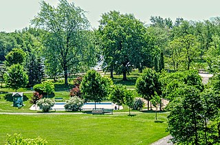
Major's Hill Park is a park in downtown Ottawa, Ontario. The park stands above the Rideau Canal at the point where it enters the Ottawa River. The parliament buildings can be seen across the canal to the west, to the north of the park is the National Gallery of Canada, and to the east are the United States embassy and the Byward Market. To the south is the Chateau Laurier hotel, built on land that was once part of the park.

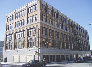
The Transportation Building, 10 Rideau Street, Ottawa, Ontario, Canada is a historic Gothic revival/Chicago school office tower. The building stands at the intersection of Sussex Drive and Rideau Street.

Osgoode Township is a former township that is now a part of the city of Ottawa, Ontario, Canada. The township along the Rideau River was established in 1798 and incorporated in 1850. It was an independent township in Carleton County until its amalgamation with the city in 2001. It remains a largely rural area with only some 23,285 inhabitants as of the 2016 census. As of the Canada 2021 Census, this had increased to 24,199. On Ottawa city council it is represented by George Darouze.
Rideau is an historic township in eastern Ontario, Canada. It is located in the rural parts of the City of Ottawa, in the extreme south. Its eastern boundary is the Rideau River, its namesake.
Strathcona Park is a large park in Ottawa, Ontario, Canada. It lies on the west bank of the Rideau River and marks the eastern edge of the Sandy Hill neighbourhood.

The Rideau Falls are two 11-metre waterfalls located in Ottawa, Ontario, Canada, where the Rideau River empties into the Ottawa River. The falls are divided by Green Island, with Ottawa's Old City Hall just to the south. To the west of the falls is the headquarters of the National Research Council while to the east are the Canada and the World Pavilion and the French Embassy. Samuel de Champlain described the falls as "...a marvelous fall...it descends a height of twenty or twenty-five fathoms with such impetuosity that it makes an arch nearly four hundred paces broad." The falls were named by the early French for their resemblance to a curtain, or rideau in French. The Rideau River was later named after the falls. The Rideau Canal was constructed to bypass these falls and the Hog's Back Falls.

The Hog's Back Falls, officially known as the Prince of Wales Falls, but rarely referred to by this name, are a series of artificial waterfalls on the Rideau River in Ottawa, Ontario, Canada. The falls are located just north of Mooney's Bay and the point where the Rideau Canal splits from the Rideau River.
Osgoode is a population centre in Osgoode Ward in the rural south end of Ottawa, Ontario, Canada. It lies surrounded by farmland, about 2 km east of the Rideau River. Until amalgamation in 2001, it was part of Osgoode Township. At the Canada 2016 Census, the population was 2,578.
Charles Ogilvy Limited, or Ogilvy's, was a department store in Ottawa, Ontario, Canada, founded in 1887. For much of the 20th century, Ogilvy's was one of Ottawa's higher-end department stores.

North Gower is a small village in eastern Ontario, originally part of North Gower Township, now part of the city of Ottawa. Surrounding communities include Richmond, Kemptville, Kars and Manotick. Public high school students in this area go to South Carleton High School in Richmond. Elementary school students go to Marlborough Public School in North Gower.
Dey's Arena, also known as Dey Brothers Rink, Dey's Skating Rink and The Arena, were a series of ice rinks and arenas located in Ottawa, Ontario, that hold importance in the early development of the organized sport of ice hockey in Canada. It was the home arena of the Ottawa Hockey Club, variously known as the Generals, the Silver Seven and the Senators from the 1890s until 1923, although it is known that games were also played at the Rideau Skating Rink in the 1890s and the Aberdeen Pavilion in 1904. The rink and arenas were built by two generations of the Dey family, who were prominent in Ottawa at the time, with a thriving boat works business serving the lumber business. The Dey family also played hockey.
The Rideau Curling Club is a curling facility and organization located in Ottawa, Ontario, Canada. Founded in 1888, the Rideau Curling Club maintains a rivalry with the Ottawa Curling Club.

Rideau View is a sub-neighbourhood of Carleton Heights in River Ward, in the west-end of Ottawa, Ontario, Canada, located near the Rideau River. It is bordered by Meadowlands Drive to the south, Claymor Avenue to the west and Dynes Road to the north. Debra Avenue is the main road that runs through the neighbourhood and there is some residential housing on Eiffel Avenue. Some of parts of the neighbourhoods are east of Prince of Wales Drive and runs parallel along the Rideau River. The area is also located close to the former city of Nepean. A major feature of the neighbourhood is a low-income housing project designed and built by the Ottawa Housing corporation. There are four high-rise condominiums on Prince of Wales at the corner of Dynes and Meadowlands.
Kars is a village on the Rideau River within Rideau-Jock Ward in the city of Ottawa, Ontario. Prior to joining the city in 2000 it was part of Rideau Township.

Ottawa Centre is an urban provincial electoral district in Ontario, Canada that has been represented in the Legislative Assembly of Ontario since 1968. While the riding's boundaries have changed over the years to account for population changes, the riding has always comprised the central areas of Ottawa, the nation's capital.
Dwyer Hill is a farming community in Rideau-Goulbourn Ward, Ottawa, Ontario, Canada.

Rideau Carleton Raceway is a Canadian horse racing and gambling complex located at 4837 Albion Road in Ottawa, Ontario. The facility began operation in 1962 and specialises in Standardbred harness racing.

Dutchy's Hole Park or Robinson Park is a park on the Rideau River in Ottawa, Ontario, Canada. It is part of the downtown Ottawa neighbourhood of Sandy Hill. The park has a wading pool, playground, and a football field, called Robinson Field. Pathways connect the park with Strathcona Park, the Rideau Campus of the University of Ottawa and via a former train bridge with Parc Riverain/River Road Park across the Rideau River in Vanier.
Rideauview Terrace is a sub-neighbourhood of Carleton Heights in River Ward in the west-end of Ottawa, Ontario, Canada. It is located just west of the Rideau Canal. It is bordered by Prince of Wales Drive to the west, Heron Drive to the south, Rideau Canal to the east and the Central Experimental Farm to the north. It is across the Rideau Canal from Carleton University.
45°12′11″N75°41′53″W / 45.203°N 75.698°W
| | This Ontario location article is a stub. You can help Wikipedia by expanding it. |