Related Research Articles

Hendry County is a county in the Florida Heartland region of the U.S. state of Florida. As of the 2020 census, the population was 39,619, down from 42,022 at the 2010 census. Its county seat is LaBelle.

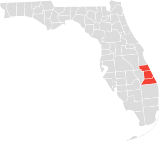
Martin County is a county located in the southeastern part of the state of Florida, in the United States. As of the 2020 census, the population was 158,431. Its county seat is Stuart. Martin County is in the Port St. Lucie, FL Metropolitan Statistical Area.

St. Lucie County is located in the southeastern portion of the U.S. state of Florida. As of the 2020 census, the population was 329,226. The county's seat is Fort Pierce, while the largest city is Port St. Lucie, making up 62% of the county's population. St. Lucie County is the principal county of the Port St. Lucie, FL Metropolitan Statistical Area.

Jensen Beach is an unincorporated community and census-designated place (CDP) in Martin County, Florida, United States. The population was 12,652 at the 2020 census. It is part of the Port St. Lucie, Florida Metropolitan Statistical Area.

Rio is an unincorporated community and census-designated place (CDP) in Martin County, Florida, United States. The population was 980 at the 2020 census. Rio is pronounced locally as if it were spelled "Rye-oh". It is part of the Port St. Lucie Metropolitan Statistical Area.
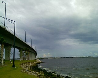
Sewall's Point is a town located on the peninsula of the same name in Martin County, Florida, United States. The population was 1,991 at the 2020 census. Both the town and the peninsula are named for Capt. Henry Edwin Sewall. It is an eastern suburb of Stuart, which is the county seat of Martin County.

Hutchinson Island South is a census-designated place (CDP) on the barrier island of Hutchinson Island in St. Lucie County, Florida, United States. The South in its name refers to its location in the southern part of St. Lucie County, as it is actually in the central part of the island as a whole. The population was 4,846 at the 2000 census. It is part of the Port St. Lucie Metropolitan Statistical Area. Its mail is delivered from Jensen Beach 34957 in nearby Martin County. The Jensen Beach post office has a postal contract substation known as Hutchinson Beach located at 11007 South Ocean Drive, but it offers only post office boxes and counter services.
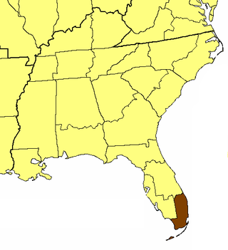
The Treasure Coast is a region in the southeast of the U.S. state of Florida. It borders the Atlantic Ocean and comprises Indian River, Martin, and St. Lucie counties. The region, whose name refers to the Spanish Treasure Fleet that was lost in a 1715 hurricane, evidently emerged from residents' desire to distinguish themselves from the Gold Coast to the south.
The Episcopal Church in Southeast Florida is a diocese of the Episcopal Church in the United States of America (ECUSA) which extends from Key West, Florida on the south, to Jensen Beach on the north and inland to Clewiston on the west. Major cities in the diocese are Miami, Fort Lauderdale and West Palm Beach. The diocese takes in all of Miami-Dade County, Broward County, Palm Beach County, and Martin County, along with the Florida Keys portion of Monroe County and the eastern part of Hendry County. The diocese is a part of Province IV of the Episcopal Church. The current diocesan bishop of Southeast Florida is Peter Eaton. The cathedral church of the diocese is Trinity Episcopal Cathedral, Miami. The diocese currently comprises 83 churches. The philanthropic outreach arm of the Episcopal Church in Southeast Florida is Episcopal Charities of Southeast Florida.

Port Mayaca is a sparsely populated place located in western Martin County, Florida, United States, on the eastern side of Lake Okeechobee.

Tuckahoe, also known as the Leach Mansion or as the Mansion at Tuckahoe, is an historic home located at 1921 North East Indian River Drive in Jensen Beach, Florida, United States. The name was thought to be a Native American word for "welcome". It is inside the present day Indian RiverSide Park and is atop the Mount Elizabeth Archeological Site, which was added to the National Register of Historic Places on September 14, 2002.

All Saints' Episcopal Church, Waveland, is an historic Carpenter Gothic church built in 1898 on Crossroads Hill in Waveland, now part of Jensen Beach, Florida. It is the oldest church building located in what is now Martin County, Florida. It is also the northernmost parish in the present-day Episcopal Diocese of Southeast Florida. The church was built on Brevard County. From 1910-25, it was in St. Lucie County. Since 1925, it has been in Martin County. Its rector, W. Frisby Hendricks III recently, retired and the parish is starting the search process to call a new rector.

Hutchinson Island consists of two barrier islands on the coast of Martin, St. Lucie, and Indian River counties, in Florida. The two islands are separated by the Fort Pierce Inlet and are known as "North Hutchinson Island" and "South Hutchinson Island".
Saint Joseph College of Florida (1890–1972) was a college operated by the Sisters of St. Joseph of Florida in St. Augustine and in Jensen Beach, Florida.

The Jensen Beach Christian Church, originally known as the Jensen Union Church, is an historic church building located at 1890 N.E. Church Street in Jensen Beach, Florida. Built in the Gothic Revival style between 1910 and 1912 of site manufactured concrete blocks cast to look like stones, it was designed to serve the needs of local Protestants. Its pulpit and pews, which are still in use, were donated by Henry Morrison Flagler, the developer of the Florida East Coast Railway, whose mainline still runs through Jensen Beach less than a block west of the church.
Wolf is a historic agricultural community in the western part of Nevada County. It lies about 12 miles south of Grass Valley at an elevation of 1578 feet. It is centered around the intersection of present day Wolf and Garden Bar roads.
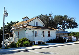
The Capt. Henry E. Sewall House is an historic wooden house now located in Indian RiverSide Park in Jensen Beach, in Martin County, Florida. Local pioneer and developer Capt. Henry E. Sewall built it in 1889 at the southern tip of Sewall's Point, the peninsula and town which bear his family name. When Capt. Sewall became the postmaster of Sewall's Point, the house served also as the Sewall's Point post office. Next to the house Capt. Sewall also built a freight dock that extended into the St. Lucie River along with a storage building at its end.
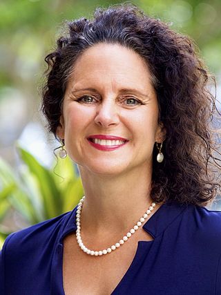
Jacqui Thurlow-Lippisch is a former at-large governing board member of the South Florida Water Management District representing St. Lucie, Martin, Palm Beach, Broward, Miami-Dade and Monroe counties. She is the author of the blog Indian River Lagoon, a former member of Florida's Constitution Revision Commission, a former mayor and commissioner of the Town of Sewall's Point, Florida, and a former Republican candidate for Martin County Commission.

Westlake is a city and the 39th municipality in Palm Beach County, Florida, United States. It is part of the Miami metropolitan area of South Florida. The population was 906 at the 2020 US Census.

The historic communities of Alachua County were populated places and/or places with a post office that were established in the 19th century or early 20th century in what is now Alachua County, Florida, but which were abandoned, annexed into an incorporated municipality, or had a much reduced population by the later part of the 20th century.
References
- ↑ Bradbury, Alford G., and Hallock, E. Story, A Chronology of Florida Post Offices, reprinted 1993, Port Salerno:Florida Classics Library. ISBN 0-9630788-1-X
27°16′N80°12′W / 27.267°N 80.200°W