Related Research Articles

Eswatini, officially the Kingdom of Eswatini and also known as Swaziland, is a landlocked country in Southern Africa. It is bordered by Mozambique to its northeast and South Africa to its north, west, and south. At no more than 200 kilometres (120 mi) north to south and 130 kilometres (81 mi) east to west, Eswatini is one of the smallest countries in Africa; despite this, its climate and topography are diverse, ranging from a cool and mountainous highveld to a hot and dry lowveld.

Eswatini is a country in Southern Africa, lying between Mozambique and South Africa. The country is located at the geographic coordinates 26°30′S31°30′E. Eswatini has an area of 17,363 square kilometres, of which 160 are water. The major regions of the country are Lowveld, Midveld and Highveld.
Public transport is the main means of transportation in Eswatini. Car ownership is low, at 32 cars per 1,000 people. The National Road Network has 1500 km of main roads and 2270 km of district roads.
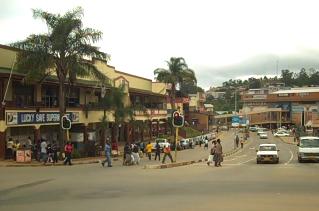
Mbabane is the capital and largest city in Eswatini. With an estimated population of 94,874 (2010), it is located on the Mbabane River and its tributary the Polinjane River in the Mdzimba Mountains. It is located in the Hhohho Region, of which it is also the capital. The average elevation of the city is 1243 meters. It lies on the MR3 road.

Hhohho is a region of Eswatini, located in the north western part of the country. Hhohho was named after the capital of King Mswati II, who expanded the Swazi territory to the north and west, taking in the districts of Barberton, Nelspruit, Carolina and Piet Retief. These areas were later acquired by what was the Province of Transvaal and today they form part of the Mpumalanga Province of South Africa. It has an area of 3,625.17 km², a population of 320,651 (2017), and is divided into 14 tinkhundla. The administrative center is the national capital of Mbabane. It borders Lubombo Region on the southeast and Manzini Region in the southwest.

The Maputo River, also called Great Usutu River, Lusutfu River, or Suthu River, is a river in South Africa, Eswatini, and Mozambique. The name Suthu refers to Basotho people who lived near the source of the river, but were attacked and displaced by Swazis. It is also said to mean 'dark brown', a description of the river's muddy water.
The music of Eswatini is composed of both ethnic Swazi music and varieties of folk music as well as modern genres such as rock, pop and hip hop, which has been popular in Eswatini since the headed by bands such as Vamoose. The popularity of hip hop in South Africa, which shares a border with Eswatini, has also helped popularize it.

South African Standard Time (SAST) is the time zone used by all of South Africa as well as Eswatini and Lesotho. The zone is two hours ahead of UTC (UTC+02:00) and is the same as Central Africa Time. Daylight saving time is not observed in either time zone. Solar noon in this time zone occurs at 30° E in SAST, effectively making Pietermaritzburg at the correct solar noon point, with Johannesburg and Pretoria slightly west at 28° E and Durban slightly east at 31° E. Thus, most of South Africa's population experience true solar noon at approximately 12:00 daily.

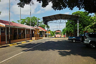
Ngwenya is a town in western Eswatini, lying near the border with South Africa, north west of Mbabane, on the MR3 road. The South African town opposite Ngwenya is Oshoek in Mpumalanga province.
Eswatini Railways (ESR), formerly known as Swaziland Railway or Swazi Rail, is the national railway corporation of Eswatini.
The following outline is provided as an overview of and topical guide to Eswatini:

Golela is a town in Kwa-Zulu Natal Province, South Africa, 45 km east of Pongola on the border with Eswatini (Swaziland). The Golela border post was recently rebuilt to meet the increasing movement of people and goods between South Africa and Eswatini.
Rugby union in Eswatini is a minor sport. They are currently ranked 83rd by the IRB.

Tourism in Eswatini is a successful industry. Most of the tourists who visit Eswatini arrive by road from South Africa. Eswatini's tourism industry developed during the apartheid era in South Africa and this shaped many of its distinctive attractions. Since the end of apartheid, Eswatini has emphasized its traditional culture as a tourist attraction.
Jeppes Reef is a small rural town on the R40 road in Ehlanzeni District Municipality in the Mpumalanga province of South Africa, 25 kilometres (16 mi) south-southeast of Kaapmuiden, and just over 2 kilometres (1.2 mi) from the border with Eswatini.

The border between Eswatini and South Africa is 430 kilometres (267 mi) long; South Africa surrounds Eswatini to the north, west, south and southeast, with Mozambique bordering it on the northeast.
Group J of the 2019 Africa Cup of Nations qualification tournament was one of the 12 groups to decide the teams which qualify for the 2019 Africa Cup of Nations finals tournament. The group consisted of four teams: Tunisia, Egypt, Niger, and Eswatini.

Matata is a town in Eswatini.

Goba railway, also called Swaziland-Maputo railway and Matsapha-Maputo railway, is a railway that connects the city of Maputo, Mozambique, to the city from Matsapha, in Eswatini. It is 466,8 km long, in a 1067 mm gauge.
References
| This South Africa location article is a stub. You can help Wikipedia by expanding it. |
| This Eswatini location article is a stub. You can help Wikipedia by expanding it. |