Belmont is an unincorporated community in Whitman County, Washington, United States.
Pullman School District #267 is a public school district in Whitman County, Washington, USA and serves the city of Pullman.

Elberton is a ghost town on the north fork of the Palouse River northeast of Colfax and northwest of Palouse in Whitman County, Washington, United States.

Joseph Canyon is a 2,000-foot (610 m)-deep basalt canyon in northern Wallowa County, Oregon, and southern Asotin County, Washington, United States.
State Route 193 (SR 193) is a 2.58-mile (4.15 km) long state highway that serves the Port of Wilma in Whitman County, located in the U.S. state of Washington. The highway parallels the Snake River from an intersection with SR 128 north of Clarkston to the Port of Wilma. The current road is a short segment of the former route that extended from U.S. Route 12 (US 12) in Clarkston to US 195 west of Colton that was added to the highway system in 1969 as Secondary State Highway 3G (SSH 3G) in 1969 and removed in 1992.

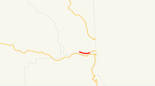
State Route 194 (SR 194) is a 21.01-mile (33.81 km) long state highway that serves the Lower Granite Dam in Whitman County, located in the U.S. state of Washington. The highway extends eastward from the Port of Almota on the Snake River to an intersection with U.S. Route 195 (US 195) west of Pullman. SR 194 was established in 1991, although the roadway has appeared on maps as early as 1933 and the Almota area being home to a ferry as early as 1893.
The Port of Whitman County is a port authority in Whitman County in the U.S. state of Washington. It operates Port of Wilma on the Snake River near the Idaho state line, where it owned a grain elevator as of 1996. The port authority was created by voters in 1958.

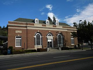
Dusty is an unincorporated community in Whitman County, Washington, United States. It lies at the junction of Washington State Route 26 and Washington State Route 127.
Camp Wooten Retreat Center is a group camp in the Washington State Park System located fifteen miles south of Pomeroy in Columbia County, Washington. It consists of a 1930s-era dining hall and a large number of cabins and other facilities on the Tucannon River and Donnie Lake in the Blue Mountains. Available activities include indoor swimming, canoeing on the lake, hiking, archery, and other athletic facilities.
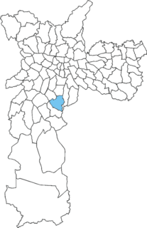
Jabaquara is one of 96 districts in the city of São Paulo, Brazil.
Almota is an extinct town in Whitman County, in the U.S. state of Washington. The GNIS classifies it as a populated place.
Bishop is an extinct town in Whitman County, in the U.S. state of Washington.
Interior is an extinct town in Whitman County, in the U.S. state of Washington.
Johnson is an unincorporated community in Whitman County, in the U.S. state of Washington.
Kitzmiller is an unincorporated community in Whitman County, in the U.S. state of Washington.
Sunshine is an unincorporated community in Whitman County, in the U.S. state of Washington.
Whelan is an unincorporated community in Whitman County, in the U.S. state of Washington.
Whitlow is an unincorporated community in Whitman County, in the U.S. state of Washington.
Wilcox is an extinct town in Whitman County, in the U.S. state of Washington. The GNIS classifies it as a populated place.