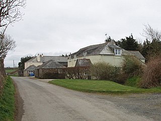
Wearde is a southeastern suburb of Saltash in Cornwall, England, UK. [1]
Saltash is a town and civil parish in southeast Cornwall, England, UK. It has a population of 16,184 at the 2011 census. It lies in the south east of Cornwall, facing Plymouth over the River Tamar. It was in the Caradon district until March 2009 and is known as "the Gateway to Cornwall". Saltash means ash tree by the salt mill. Saltash is best known for Isambard Kingdom Brunel's Royal Albert Bridge, a towering 134-foot bridge, constructed in the 1850s, which frequently transports trains over the River Tamar.
Cornwall is a county in South West England in the United Kingdom. The county is bordered to the north and west by the Celtic Sea, to the south by the English Channel, and to the east by the county of Devon, over the River Tamar which forms most of the border between them. Cornwall forms the westernmost part of the South West Peninsula of the island of Great Britain. The furthest southwestern point of Great Britain is Land's End; the southernmost point is Lizard Point. Cornwall has a population of 563,600 and covers an area of 3,563 km2 (1,376 sq mi). The county has been administered since 2009 by the unitary authority, Cornwall Council. The ceremonial county of Cornwall also includes the Isles of Scilly, which are administered separately. The administrative centre of Cornwall, and its only city, is Truro.
England is a country that is part of the United Kingdom. It shares land borders with Wales to the west and Scotland to the north-northwest. The Irish Sea lies west of England and the Celtic Sea lies to the southwest. England is separated from continental Europe by the North Sea to the east and the English Channel to the south. The country covers five-eighths of the island of Great Britain, which lies in the North Atlantic, and includes over 100 smaller islands, such as the Isles of Scilly and the Isle of Wight.
Glendurgan Garden is a National Trust garden situated above the hamlet of Durgan on the Helford River and near Mawnan Smith, in the civil parish of Mawnan, Cornwall, England, United Kingdom.
Windsor is a hamlet in Cornwall, England, United Kingdom. It is located half-a-mile east of Lansallos village.
Gwinear–Gwithian is a coastal civil parish in west Cornwall, England, United Kingdom. It includes the villages of Connor Downs, Gwinear, Gwithian, Reawla and Rosewarne. The parish is situated approximately two miles (3 km) east of Hayle two miles (3 km) west of Camborne.
Philleigh is a civil parish and village in Cornwall, England, in the United Kingdom; one of the four in the Roseland Peninsula.
There are seventeen disused railway stations on the Cornish Main Line between Plymouth in Devon and Penzance in Cornwall, England. The remains of nine of these can be seen from passing trains. While a number of these were closed following the so-called "Beeching Axe" in the 1960s, many of them had been closed much earlier, the traffic for which they had been built failing to materialise.
Southdown is a coastal village in south-east Cornwall, England, United Kingdom. It is situated on the banks of the Hamoaze east of Millbrook on the Rame Peninsula, about five miles (8 km) south of Saltash.
Trerulefoot is a village in southeast Cornwall, England, United Kingdom. It is located on the A38 trunk road approximately halfway between the towns of Saltash and Liskeard. Trerulefoot has a farm shop, two cafés and a petrol filling station.
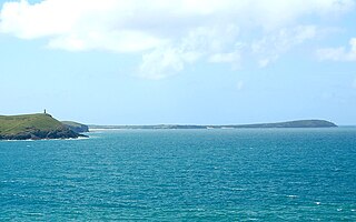
Trevose Head is a headland on the Atlantic coast of north Cornwall, United Kingdom. It is situated approximately 5 miles (8.0 km) west of Padstow. The South West Coast Path runs around the whole promontory and is within the Cornwall Area of Outstanding Natural Beauty and the Trevose Head Heritage Coast. In clear weather, visitors to Trevose Head can see virtually the whole length of the north Cornwall coast; to the north, the view extends beyond the Cornwall county boundary to Hartland Point, Devon; to the south, it extends beyond St Ives to the headland at Pendeen Watch.
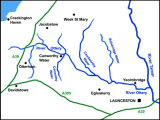
The River Ottery is a small river in northeast Cornwall, United Kingdom. The river is about twenty miles (32 km) long from its source southeast of Otterham to its confluence with the River Tamar at Nether Bridge, two miles (3.2 km) northeast of Launceston.
Helebridge is a hamlet west of Marhamchurch in northeast Cornwall, England.
Northcott is a hamlet in Cornwall, England. Northcott is north of Bude and on the coast close to Northcott Mouth.
Pencuke is a hamlet near Higher Crackington in northeast Cornwall, England, UK.
Pengold is a hamlet near St Gennys in Cornwall, England, UK. Pengold is southwest of Higher Crackington.
Rosecare is a hamlet in the parish of St Gennys, Cornwall, England. Rosecare is east of Higher Crackington.
South Pill is a suburb of Saltash in the civil parish of Saltash, east Cornwall, England, the word "pill" deriving from a tidal pool related to the estuary of the River Tamar.
South Wheatley is a hamlet between Canworthy Water and Maxworthy in Cornwall, England, United Kingdom.
Trehan is a hamlet near Saltash in Cornwall, England, United Kingdom.
Treskinnick Cross is a hamlet at Grid ref. SX2098 on the A39 main road near Poundstock in northeast Cornwall, England, United Kingdom.
Trengune is a hamlet in Cornwall, England, United Kingdom. It is part of the civil parish of Warbstow and is located 1.5 miles north and 1 mile west of the village. The River Ottery passes through Trengune. The earliest record of Trengune was in 1356; the meaning is "farm at the downs".
Coordinates: 50°24′18″N4°13′01″W / 50.405°N 4.217°W
A geographic coordinate system is a coordinate system that enables every location on Earth to be specified by a set of numbers, letters or symbols. The coordinates are often chosen such that one of the numbers represents a vertical position and two or three of the numbers represent a horizontal position; alternatively, a geographic position may be expressed in a combined three-dimensional Cartesian vector. A common choice of coordinates is latitude, longitude and elevation. To specify a location on a plane requires a map projection.
This Cornwall location article is a stub. You can help Wikipedia by expanding it. |