The Geography Markup Language (GML) is the XML grammar defined by the Open Geospatial Consortium (OGC) to express geographical features. GML serves as a modeling language for geographic systems as well as an open interchange format for geographic transactions on the Internet. Key to GML's utility is its ability to integrate all forms of geographic information, including not only conventional "vector" or discrete objects, but coverages and sensor data.

The European Organisation for the Safety of Air Navigation, commonly known as Eurocontrol, is an international organisation working to achieve safe and seamless air traffic management across Europe. Founded in 1960, Eurocontrol currently has 41 member states and is headquartered in Brussels, Belgium. It has several local sites as well, including an Innovation Hub in Brétigny-sur-Orge, France, the Aviation Learning Centre (ALC) in Luxembourg, and the Maastricht Upper Area Control Centre (MUAC) in Maastricht, the Netherlands. The organisation employs approximately two thousand people, and operates with an annual budget in excess of half a billion Euro.
Keyhole Markup Language (KML) is an XML notation for expressing geographic annotation and visualization within two-dimensional maps and three-dimensional Earth browsers. KML was developed for use with Google Earth, which was originally named Keyhole Earth Viewer. It was created by Keyhole, Inc, which was acquired by Google in 2004. KML became an international standard of the Open Geospatial Consortium in 2008. Google Earth was the first program able to view and graphically edit KML files, but other projects such as Marble have added KML support.
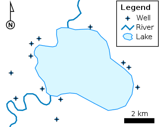
Simple Features is a set of standards that specify a common storage and access model of geographic feature made of mostly two-dimensional geometries used by geographic information systems. It is formalized by both the Open Geospatial Consortium (OGC) and the International Organization for Standardization (ISO).
In aviation, an Aeronautical Information Publication is defined by the International Civil Aviation Organization as a publication issued by or with the authority of a state and containing aeronautical information of a lasting character essential to air navigation. It is designed to be a manual containing thorough details of regulations, procedures and other information pertinent to flying aircraft in the particular country to which it relates. It is usually issued by or on behalf of the respective civil aviation administration.
ASTERIX is a standard for the exchange of air traffic services (ATS) information. It is developed and maintained by the European ATS organization Eurocontrol. ASTERIX is surveillance data format which is being adopted by the world users community as the universal standard in this domain today.

CityGML is an open standardised data model and exchange format to store digital 3D models of cities and landscapes. It defines ways to describe most of the common 3D features and objects found in cities and the relationships between them. It also defines different standard levels of detail (LoDs) for the 3D objects, which allows the representation of objects for different applications and purposes, such as simulations, urban data mining, facility management, and thematic inquiries.
Geospatial metadata is a type of metadata applicable to geographic data and information. Such objects may be stored in a geographic information system (GIS) or may simply be documents, data-sets, images or other objects, services, or related items that exist in some other native environment but whose features may be appropriate to describe in a (geographic) metadata catalog.
The Aeronautical Information Exchange Model (AIXM) is designed to enable the management and distribution of Aeronautical Information Services (AIS) data in digital format. AIXM is based on Geography Markup Language (GML) and is one of the GML Application Schemas which is applicable for the Aeronautical domain. It was developed by the US Federal Aviation Administration (FAA), the US National Geospatial Intelligence Agency (NGA) and the European Organisation for the Safety of Air Navigation (EUROCONTROL).The current version is AIXM 5.1.1.
The Open Geospatial Consortium Web Coverage Service Interface Standard (WCS) defines Web-based retrieval of coverages – that is, digital geospatial information representing space/time-varying phenomena.
Observations and Measurements (O&M) is an international standard which defines a conceptual schema encoding for observations, and for features involved in sampling when making observations. While the O&M standard was developed in the context of geographic information systems, the model is derived from generic patterns proposed by Fowler and Odell, and is not limited to spatial information. O&M is one of the core standards in the OGC Sensor Web Enablement suite, providing the response model for Sensor Observation Service (SOS).

The OpenMI Standard defines an interface that allows models to exchange data in memory at run-time. When the standard is implemented, existing models can be run simultaneously and share information, for instance at each time step, making model integration feasible at the operational level. The OpenMI standard was created with the intent to facilitate model integration, which is helpful in understanding and predicting process interactions and achieving an integrated approach to environmental management.

CIMACT is EUROCONTROL's Civil-Military Air Traffic Management Co-ordination Tool.

The Open Geospatial Consortium (OGC), an international voluntary consensus standards organization, originated in 1994. In the OGC, more than 500 commercial, governmental, nonprofit and research organizations collaborate in a consensus process encouraging development and implementation of open standards for geospatial content and services, sensor web and Internet of Things, GIS data processing and data sharing.
The Sensor Observation Service (SOS) is a web service to query real-time sensor data and sensor data time series and is part of the Sensor Web. The offered sensor data consists of data directly from the sensors, which are encoded in the Sensor Model Language (SensorML), and the measured values in the Observations and Measurements encoding format. The web service as well as both file formats are open standards and specifications of the same name defined by the Open Geospatial Consortium (OGC).
WaterML is a technical standard and information model used to represent hydrological time series structures. The current version is WaterML 2.0, released an open standard of the Open Geospatial Consortium (OGC).
IWXXM is a format for reporting weather information in XML/GML. IWXXM includes XML/GML-based representations for products standardized in International Civil Aviation Organization (ICAO) Annex III and World Meteorological Organization (WMO) No. 49, Vol II, such as METAR/SPECI, TAF, SIGMET, AIRMET, Tropical Cyclone Advisory, Volcanic Ash Advisory and Space Weather Advisory. IWXXM products are used for operational exchanges of meteorological information for use in aviation.
The Weather Information Exchange Model (WXXM) is designed to enable the management and distribution of weather data in digital format (XML). WXXM version 2.0, set to be finalized in 2014, is based on Geography Markup Language (GML) and is one of the GML Application Schemas. It is being developed by the US Federal Aviation Administration (FAA) and the European Organisation for the Safety of Air Navigation (EUROCONTROL). WXXM is a member of a family of data models designed for use in aviation safety, notably Aeronautical Information Exchange Model (AIXM) and the Flight Information Exchange Model (FIXM).
A GeoPackage (GPKG) is an open, non-proprietary, platform-independent and standards-based data format for geographic information system implemented as a SQLite database container. Defined by the Open Geospatial Consortium (OGC) with the backing of the US military and published in 2014, GeoPackage has seen widespread support from various government, commercial, and open source organizations.
SensorThings API is an Open Geospatial Consortium (OGC) standard providing an open and unified framework to interconnect IoT sensing devices, data, and applications over the Web. It is an open standard addressing the syntactic interoperability and semantic interoperability of the Internet of Things. It complements the existing IoT networking protocols such CoAP, MQTT, HTTP, 6LowPAN. While the above-mentioned IoT networking protocols are addressing the ability for different IoT systems to exchange information, OGC SensorThings API is addressing the ability for different IoT systems to use and understand the exchanged information. As an OGC standard, SensorThings API also allows easy integration into existing Spatial Data Infrastructures or Geographic Information Systems.


