| Authority overview | |
|---|---|
| Formed | February 27, 2014 [1] |
| Jurisdiction | Webb County, Texas |
The Webb County - City of Laredo Regional Mobility AuthorityakaWebb County - Laredo RMA in Texas, USA, does not currently operate any roads, but in the future will operate toll roads located inside Webb County.
The Webb County - Laredo RMA was inaugurated on February 27, 2014.
The Authority has a series of road projects: [2]

Webb County is a county located in the U.S. state of Texas. As of the 2020 census, its population was 267,114. Its county seat is Laredo. The county was named after James Webb (1792–1856), who served as secretary of the treasury, secretary of state, and attorney general of the Republic of Texas, and later judge of the United States District Court following the admission of Texas to statehood. By area, Webb County is the largest county in South Texas and the sixth-largest in the state. Webb County comprises the Laredo metropolitan area. Webb County is the only county in the United States to border three foreign states or provinces, sharing borders with Coahuila, Nuevo Leon, and Tamaulipas.

Interstate 69 (I-69) is an Interstate Highway in the United States currently consisting of eight unconnected segments. The longest segment runs from Evansville, Indiana, northeast to the Canadian border in Port Huron, Michigan, and includes the original continuous segment from Indianapolis, Indiana, to Port Huron of 355.8 miles (572.6 km). The remaining separated segments are variously completed and posted or not posted sections of an extension southwest to the Mexican border in Texas. Of this extension—nicknamed the NAFTA Superhighway because it would help trade with Canada and Mexico spurred by the North American Free Trade Agreement (NAFTA)—seven pieces in Laredo, Texas; Pharr, Texas; Brownsville, Texas; Corpus Christi, Texas; Houston, Texas; northwestern Mississippi; and Memphis, Tennessee, have been built or upgraded and signposted as I-69. Indiana completed the fifth segment that extends I-69 through that state in August 2024.

U.S. Highway 96 (US 96) is a north–south United States Numbered Highway that runs for about 117.11 miles (188.47 km) entirely in the U.S state of Texas. Its number is a violation of the standard numbering convention, as even-numbered two-digit highways are east–west routes by rule. As of 2004, the highway's southern terminus is in Port Arthur at an intersection with State Highway 87 (SH 87). Its northern terminus is in Tenaha at an intersection with US 59 /(Future I-369) and US 84.

U.S. Route 59 is a north–south United States highway. A latecomer to the U.S. numbered route system, US 59 is now a border-to-border route, part of the NAFTA Corridor Highway System. It parallels U.S. Route 75 for nearly its entire route, never much more than 100 miles (160 km) away, until it veers southwest in Houston, Texas. Its number is out of place since US 59 is either concurrent with or entirely west of U.S. Route 71. The highway's northern terminus is 9 mi (14 km) north of Lancaster, Minnesota, at the Lancaster–Tolstoi Border Crossing on the Canada–US border, where it continues as Manitoba Highway 59. Its southern terminus is at the Mexico–US border in Laredo, Texas, where it continues as Mexican Federal Highway 85D.
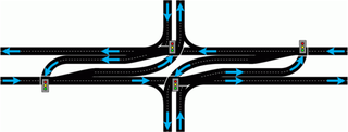
A superstreet is a type of road intersection that is a variation of the Michigan left. In this configuration, in contrast to the Michigan left, traffic on the minor road is not permitted to proceed straight across the major road or highway. Drivers on the minor road wishing to turn left or go straight must turn right onto the major road, then, a short distance away, queue (wait) into a designated U-turn lane in the median. When traffic clears, they complete the U-turn and then either go straight or make a right turn when they intersect the other half of the minor road.

Texas state highways are a network of highways owned and maintained by the U.S. state of Texas. The Texas Department of Transportation (TxDOT) is the state agency responsible for the day-to-day operations and maintenance of the system. Texas has the largest state highway system, followed closely by North Carolina's state highway system. In addition to the nationally numbered Interstate Highways and U.S. Highways, the highway system consists of a main network of state highways, loops, spurs, and beltways that provide local access to the other highways. The system also includes a large network of farm to market roads that connect rural areas of the state with urban areas and the rest of the state highway system. The state also owns and maintains some park and recreational roads located near and within state and national parks, as well as recreational areas. All state highways, regardless of classification, are paved roads. The Old San Antonio Road, also known as the El Camino Real, is the oldest highway in the United States, first being blazed in 1691. The length of the highways varies from US 83's 893.4 miles (1,437.8 km) inside the state borders to Spur 200 at just 0.05 miles long.
The Harris County Toll Road Authority maintains and operates a 103-mile (165.8 km) toll road system in the Greater Houston area of Texas, United States. Its headquarters are located in Houston's Fairbanks/Northwest Crossing neighborhood.

State Highway 44 (SH 44) is a Texas state highway that runs from west of Encinal to Corpus Christi, Texas. This highway is also known as the Cesar Chavez Memorial Highway outside the city limits of Robstown, Banquete, Agua Dulce, Alice, and Corpus Christi in Nueces and Jim Hogg counties.

Loop 375 is a beltway that partially encircles the city of El Paso, Texas. The beltway is mostly a freeway, except for its northern section, which includes at-grade intersections. The highway passes through various areas of El Paso, funneling traffic within and around the city. The road is known locally under different names, as Woodrow Bean Transmountain Drive in the northern section, Purple Heart Memorial Freeway in the northeastern section, Joe Battle Boulevard in the eastern section, the César Chávez Border Highway in the southern section, and the Border West Expressway on the southwest section.

Loop 49 is a currently 32-mile (51 km) circular freeway that, along with I-20, will encircle the city of Tyler and serve other various communities in Northeast Texas upon its completion. Routing of the loop north of I-20 bypasses Lindale to the west and passes by the west and south sides of Tyler south of I-20. The highway interconnects suburban areas and areas of potential development around Tyler with I-20 and provides local areas easier access to the Dallas–Fort Worth metroplex.
The Central Texas Regional Mobility Authority is an independent government agency created in 2002 to improve the transportation system in Travis and Williamson Counties in Texas. The Mobility Authority is headquartered at 3300 N. IH 35 in Austin.

Loop 20, also known as the Bob Bullock Loop and Cuatro Vientos Road, is a highway loop that runs to the north and east of the city of Laredo, Texas. Loop 20 extends from the World Trade International Bridge at its northern point to Mangana-Hein Road at its southern point. The current route varies in construction from a 2-lane road to a freeway with frontage roads.

Farm to Market Road 1472 (FM 1472) is a farm-to-market road in the U.S. state of Texas that connects the industrial area of Laredo to the Laredo–Colombia Solidarity International Bridge, and then runs roughly parallel to the Rio Grande into rural Webb County. In the urban sections of Laredo, it is a six-lane route known locally as Mines Road.
U.S. Highway 59 (US 59) in the U.S. state of Texas is named the Lloyd Bentsen Highway, after Lloyd Bentsen, former U.S. senator from Texas. In northern Houston, US 59, co-signed with Interstate 69 (I-69), is the Eastex Freeway. To the south, which is also co-signed with I-69, it is the Southwest Freeway. The stretch of the Southwest Freeway just west of The Loop was formerly one of the busiest freeways in North America, with a peak AADT of 371,000 in 1998.
The North East Texas Regional Mobility Authority is a Regional Mobility Authority covering several counties in the U.S. state of Texas. The NET RMA was created by the Texas Transportation Commission in 2004, originally containing the counties of Smith and Gregg. It was the 5th RMA established in the State of Texas, and is headquartered in Tyler. The authority claims to "provide solutions to expedite transportation and mobility projects that will improve the quality of life, enhance the regional economy and assure efficient mobility in the North East Texas Region."

Interstate 69 (I-69) is an Interstate Highway that is in the process of being built in the U.S. state of Texas. It is part of a longer I-69 extension known as the NAFTA superhighway, that, when completed, will connect Canada to Mexico. In Texas, it will connect Tenaha and the Louisiana segment of the route through the eastern part of the state and along the Texas Gulf Coast to Victoria, where it will split into three branches: I-69E to Brownsville, I-69C to Pharr, and I-69W to Laredo. The first segment of I-69 in Texas was opened in 2011 near Corpus Christi. The American Association of State Highway and Transportation Officials (AASHTO) approved an additional 58 miles (93 km) of U.S. Highway 77 (US 77) from Brownsville to the Willacy–Kenedy county line for designation as I-69, which was to be signed as I-69E upon concurrence from the Federal Highway Administration (FHWA). FHWA approval for this segment was announced on May 29, 2013. By March 2015, a 74.9-mile (120.5 km) section of US 59 had been completed and designated as I-69 through Greater Houston. As of 2024, short segments near the southern terminuses of the three branch routes have also all been completed. These branches are planned to be connected to the rest of Interstate 69.
Wurzbach Parkway is a part freeway and part major arterial road in San Antonio, Texas, built to provide relief on Interstate 410 (I-410) and Loop 1604 on the city's north side. The highway is named for Harry M. Wurzbach, who represented the San Antonio area in Congress as a Republican in the 1920s and 1930s. The congressman's name was first applied to the connecting Wurzbach Road. The highway's western third was built as an expressway with at-grade intersections and the remainder as a freeway. The opening in September 2015 of an interchange with U.S. Highway 281 completed primary construction of the parkway. The highway, along with part of Wurzbach Road near the Ingram Park Mall, is maintained by the Texas Department of Transportation despite not carrying a state highway designation. Rather, it is being developed and maintained under the Principal Arterial State System (PASS) program, under which it is designated as PASS Project 1502. The parkway includes an interchange with US 281, and drivers can access I-10 and I-35 via local roads that extend the parkway.
There are approximately 25 current toll roads in the state of Texas. Toll roads are more common in Texas than in many other U.S. states, since the relatively low revenues from the state's gasoline tax limits highway planners' means to fund the construction and operation of highways.

Interstate 2 (I-2) is a partially completed Interstate Highway running through the Lower Rio Grande Valley of South Texas. It begins at the intersection of US Highway 83 (US 83) and Business US 83 in Peñitas and heads eastward before terminating at I-69E/US 77/US 83 in Harlingen. A westward extension around La Joya has been completed, and is designated as I-2 East. For almost its entire length, I-2 runs concurrently with US 83. I-2 also parallels Mexican Federal Highway 2 (Fed. 2), another major east–west route that traces the Mexico–US border along the Mexican side of the Rio Grande. When completed, the western terminus will be the city of Laredo. The route is one of the more recently designated Interstate Highways; it was signed as an Interstate in 2013. Its construction is part of an expansion of the Interstate System into southern Texas that includes the three branches of I-69. It currently intersects I-69E and I-69C and will, when completed to Laredo, terminate I-69W as well. This complex of Interstate Highways does not yet connect to the rest of the system.

Interstate 69W (I-69W) is a relatively short north–south Interstate Highway running through South Texas in the United States. The freeway begins northeast of the middle of the World Trade International Bridge in Laredo and ends at I-35. In the future, I-69W will head northeast for 180 miles (290 km) before terminating near Victoria as both I-69E and I-69W merge to form I-69. For its entire length, I-69W runs concurrently with U.S. Highway 59 (US 59).
| | This Texas-related article is a stub. You can help Wikipedia by expanding it. |