Related Research Articles
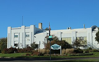
Polk County is a county in the U.S. state of Wisconsin. As of the 2020 census, the population was 44,977. Its county seat is Balsam Lake. The county was created in 1853 and named for United States President James K. Polk.

Eau Claire County is a county located in the U.S. state of Wisconsin. As of the 2020 census, the population was 105,710. Its county seat is Eau Claire. The county took its name from the Eau Claire River.

Lodi is a city in Columbia County, Wisconsin, United States. The population was 3,209 at the 2022 United States census. Lodi is part of the Madison Metropolitan Statistical Area.
Elk Mound is a kame, a type of irregularly shaped hill formed by glacial debris, in northwestern Wisconsin. It has an elevation of over 1,200 feet above sea level. The hill lends its name to the village of Elk Mound, Wisconsin, as well as the Town of Elk Mound.

Manitowish is an unincorporated community located within the town of Mercer, Iron County, Wisconsin, United States. It is located at the junction of U.S. Route 51, Wisconsin Highway 47 and Wisconsin Highway 182.

Tunnel City is an unincorporated census-designated place in the town of Greenfield, Monroe County, Wisconsin, United States, named after the train tunnel through a hill just to the west of town.
Sugar Bush is an unincorporated community located entirely within the town of Maple Creek in northwest Outagamie County, Wisconsin, United States. Sugar Bush is classified as a Class U6 Community by the USGS, being a populated place located wholly or substantially outside the boundaries of any incorporated place or CDP with a recognized authoritative common name.

Medina, originally Young's Corner, is an unincorporated community in the Town of Dale in southwest Outagamie County, Wisconsin, United States. It is located 3.5 miles (5.6 km) south of the village of Hortonville, 11 miles (18 km) west of Appleton, and 20 miles (32 km) northwest of Oshkosh.

The Big Rib River is a river in central Wisconsin. It originates in northeastern Taylor County at Rib Lake, and flows into Marathon County where it joins the Wisconsin River. "Rib River" is a translation of the Native American name.
Bluff Siding or Atlanta Station is an unincorporated community located in the town of Buffalo, in Buffalo County, Wisconsin, United States.
Callon is a neighborhood of the Village of Weston, Marathon County, in the United States. It was an unincorporated community until Weston's incorporation as a village.
Fort Howard was a city in Brown County, Wisconsin, United States. It was first incorporated as a "borough" of 664 acres on October 13, 1856. As the result of a referendum on the union of the two cities held on April 2, 1895, the city was entirely annexed to the City of Green Bay and ceased to exist.
Beartrap Creek is a stream in Ashland and Bayfield counties, Wisconsin, in the United States.
Birch Creek is a stream in Menominee County, Michigan, in the United States. It is a tributary of Springer Creek.

Boxelder Creek is a stream in Pennington, Meade and Lawrence counties, South Dakota, in the United States. It is a tributary of the Cheyenne River.
Duck Creek is a stream in Brown and Outagamie counties, Wisconsin, in the United States.
Francis Creek is a stream in Manitowoc County, Wisconsin, in the United States.
Whitewood Creek is a stream in Butte, Meade and Lawrence counties, in the U.S. state of South Dakota.
Stinkingwater Creek is a stream in the U.S. state of South Dakota. It is a tributary of Belle Fourche River.
Wildcat Creek is a stream in southern St. Francois County in the U.S. state of Missouri. It is a tributary of Wachita Creek.
References
- ↑ "U.S. Geological Survey Geographic Names Information System: Wedges Creek". geonames.usgs.gov. Retrieved 2018-11-05.
- ↑ Chicago and North Western Railway Company (1908). A History of the Origin of the Place Names Connected with the Chicago & North Western and Chicago, St. Paul, Minneapolis & Omaha Railways. p. 196.
44°28′57″N90°40′10″W / 44.48250°N 90.66944°W
| | This article about a location in Clark County, Wisconsin is a stub. You can help Wikipedia by expanding it. |
| | This article related to a river in Wisconsin is a stub. You can help Wikipedia by expanding it. |