Wehrsdorf

Last updated
Wehrsdorf 03.JPG

Wehrsdorf (German) or Wernarjecy (Upper Sorbian) is a small village in a valley of the Lusatian Highlands in the region of Upper Lusatia (Oberlausitz) in Saxony, Germany. It has about 1,776 inhabitants and belongs to an administrative community of three different villages, with Sohland an der Spree and Taubenheim. This community is offícially called Sohland after the largest of these villages. Altogether, the community has about 7,700 inhabitants. [1] The village is near the border to the Czech Republic.

Contents

Monuments

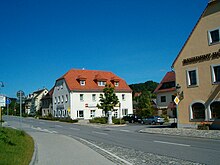
The most important building in the village is a Lutheran church, built in 1725 in the Baroque style. The tower is more than 40 meters high and sends its greetings over the valleys of the region. Near the church is an old cemetery with its typical flowered graves. The most important architectural heritage of the southern part of Upper Lusatia is the so-called "Umgebindehäuser", special, half-timbered houses which unite the differences of the Slavic and the Franconian styles of wood houses. Most of the present houses were built between 1850-1890.

Religion

Most people are still atheists, as in the time of official Socialism, but there is also a Lutheran tradition and most people are linked to this religion, as well as a strong Catholic minority. Upper Lusatia is typically a religious mixed region.

Economy

In the time before reunification in 1990, the village was still a typical "Saxon industrial village" with four big and several small enterprises, all state-owned. They produced furniture, clothing, metal instruments and more. After the reunification, most of the firms were not able to survive; only the firm that produced furnitures still exists. The high rate of unemployment today is also the primary reason why so many people have left the region. But in comparison with other villages of Upper Lusatia, Wehrsdorf is still well off.

Before 1990, Upper Lusatia was a tourist area, and tourism is still important. There are four restaurants, a hotel (****) and several private bed-and-breakfasts.

Historical Population

YearPopulation
154736 Hufners
177718 Hufners,
53 gardeners, 122 tenant farmers
18341436
18712207
18902300
19102351
19252357
19392331
19462614
19502740
19642670
19901900

Quelle: http://hov.isgv.de/Wehrsdorf

Related Research Articles

<span class="mw-page-title-main">Saxony</span> State in Germany

Saxony, officially the Free State of Saxony, is a landlocked state of Germany, bordering the states of Brandenburg, Saxony-Anhalt, Thuringia, Bavaria, as well as the countries of Poland and the Czech Republic. Its capital is Dresden, and its largest city is Leipzig. Saxony is the tenth largest of Germany's sixteen states, with an area of 18,413 square kilometres (7,109 sq mi), and the sixth most populous, with more than 4 million inhabitants.

Villages with fortified churches in Transylvania UNESCO World Heritage Site

The south-eastern Transylvania region in Romania currently has one of the highest numbers of existing fortified churches from the 13th to 16th centuries. It has more than 150 well preserved fortified churches of a great variety of architectural styles.

<span class="mw-page-title-main">Sorbs</span> Ethnic group in Germany

Sorbs are a West Slavic ethnic group predominantly inhabiting the parts of Lusatia located in the German states of Saxony and Brandenburg. Sorbs traditionally speak the Sorbian languages, which are closely related to Czech, Polish, Kashubian, Silesian, and Slovak. Upper Sorbian and Lower Sorbian are officially recognized minority languages in Germany.

Lusatia Historical region

Lusatia is a historical region in Central Europe, split between Germany and Poland. Lusatia stretches from the Bóbr and Kwisa rivers in the east to the Pulsnitz and Black Elster rivers in the west, and is located within the German states of Saxony and Brandenburg as well as in the Polish voivodeships of Lower Silesia and Lubusz. Lusatia's central rivers are the Spree and the Lusatian Neisse, which constitutes the border between Germany and Poland since 1945. The Lusatian Mountains, separate Lusatia from Bohemia in the south. Lusatia is traditionally divided into Upper Lusatia and Lower Lusatia.

Gera City in Thuringia, Germany

Gera is, with around 93,000 inhabitants, the third-largest city of Thuringia after Erfurt and Jena as well as the easternmost city of the Thüringer Städtekette, an almost straight string of cities consisting of the six largest Thuringian cities from Eisenach in the west, via Gotha, Erfurt, Weimar and Jena to Gera in the east. Gera is the largest city in the Vogtland, and one of its historical capitals along with Plauen, Greiz and Weida. The city lies in the East Thuringian Hill Country, in the wide valley of the White Elster, between Greiz (upstream) and Leipzig (downstream). Gera is located in the Central German Metropolitan Region, approximately 60 kilometres south of Saxony's largest city of Leipzig, 80 km east of Thuringia's capital Erfurt, 120 km west of Saxony's capital Dresden and 90 km north of Bavaria's city of Hof (Saale).

<span class="mw-page-title-main">Oberwart</span> Place in Burgenland, Austria

Oberwart is a town in Burgenland in southeast Austria on the banks of the Pinka River, and the capital of the district of the same name. Oberwart is the cultural capital of the small ethnic Hungarian minority in Burgenland, living in the Upper Őrség or Wart microregion.

Saint-Gilles, Belgium Municipality of the Brussels-Capital Region, Belgium

Saint-Gilles or Sint-Gillis is one of the 19 municipalities of the Brussels-Capital Region, Belgium. Located in the southern part of the region, it is bordered by the City of Brussels, Anderlecht, Forest and Ixelles. In common with all of Brussels' municipalities, it is legally bilingual (French–Dutch).

Neuzelle Municipality in Brandenburg, Germany

Neuzelle is a municipality in the Oder-Spree district of Brandenburg, Germany, the administrative seat of Amt Neuzelle. It is best known for Cistercian Neuzelle Abbey and its Neuzeller Kloster Brewery.

Lower Lusatia Geographic region in Europe

Lower Lusatia is a historical region in Central Europe, stretching from the southeast of the German state of Brandenburg to the southwest of Lubusz Voivodeship in Poland. Like adjacent Upper Lusatia in the south, Lower Lusatia is a settlement area of the West Slavic Sorbs whose endangered Lower Sorbian language is related to Upper Sorbian and Polish.

<span class="mw-page-title-main">Upper Lusatia</span> Historical region in Germany and Poland

Upper Lusatia is a historical region in Germany and Poland. Along with Lower Lusatia to the north, it makes up the region of Lusatia, named after the Slavic Lusici tribe. Both parts of Lusatia are home to the West Slavic minority group of the Sorbs.

Lusatian Highlands

The Lusatian Highlands or Lusatian Hills form a hilly region in Germany and the Czech Republic. A western extension of the Sudetes range, it is located on the border of the German state of Saxony with the Czech Bohemian region. It is one of the eight natural landscapes of Upper Lusatia.

<span class="mw-page-title-main">Sohland an der Spree</span> Municipality in Saxony, Germany

Sohland an der Spree (German) or Załom is a municipality in the district of Bautzen in Saxony in Germany near the border of the Czech Republic in a region called Lusatia. The river Spree flows through the village. Together with some smaller villages it constitutes one of the biggest villages or communities with about 7,700 inhabitants. The most iconic monument of the village is the "Himmelsbrücke" ; it is said that the bridge will break when someone tells a lie while standing on it.

<span class="mw-page-title-main">Săliște</span> Town in Sibiu, Romania

Săliște is a town in Sibiu County, in the centre of Romania, 21 km (13 mi) west of the county capital, Sibiu. Declared a town in 2003, it is the main locality in the Mărginimea Sibiului area.

Bakonycsernye is a village in Fejér county, Hungary.

<span class="mw-page-title-main">Schirgiswalde</span> Ortsteil of Schirgiswalde-Kirschau in Saxony, Germany

Schirgiswalde is a town and a former municipality in the district of Bautzen in Saxony in Germany. Since 1 January 2011, it is part of the town Schirgiswalde-Kirschau. It is located on the river Spree, 15 km south of Bautzen. The small town is an official place of relaxation. Together with the villages of Crostau and Kirschau it represents the administrative community of Schirgiswalde. Some smaller parts of the town are Neuschirgiswalde upon a hill and Petersbach.

<span class="mw-page-title-main">Crostau</span> Ortsteil of Schirgiswalde-Kirschau in Saxony, Germany

Crostau is a village and former municipality in Upper Lusatia in the Bautzen district of eastern Saxony in Germany. It became part of the municipality of Schirgiswalde-Kirschau on 1 January 2011.

<span class="mw-page-title-main">Kirschau</span> Ortsteil of Schirgiswalde-Kirschau in Saxony, Germany

Kirschau is a village and a former municipality in Upper Lusatia in the district of Bautzen in Saxony in Germany. Since 1 January 2011, it is part of the town Schirgiswalde-Kirschau. It is situated in a region called Lausitzer Bergland in the valley of the Spree and the Pilke, between the "Mönchswalderberg" and the "Lärchenberg" and belongs in respects of administration to the district of Bautzen.

Burkau Municipality in Saxony, Germany

Burkau (German) or Porchow (Sorbian) is a municipality in the east of Saxony, in the district of Bautzen in Germany.

<span class="mw-page-title-main">Cunewalde</span> Municipality in Saxony, Germany

Cunewalde or Kumwałd is a municipality in the district of Bautzen in the east of the federal Free State of Saxony in Germany. It lies between the cities of Bautzen and Löbau in a valley between the hills of the Czorneboh, the Hochstein and the Bieleboh, all part of the northernmost mountain ranges of the Lusatian Highlands. It is one of the more populous villages in Upper Lusatia and the longest street village in all of Germany.

<span class="mw-page-title-main">Štítnik</span> Municipality in Slovakia

Štítnik is a village and municipality in the Rožňava District in the Košice Region of middle-eastern Slovakia.

References

Coordinates: 51°03′N14°23′E / 51.050°N 14.383°E / 51.050; 14.383