Kilgetty is a village immediately north of Saundersfoot in Pembrokeshire, Wales, at the junction of the A477 between St. Clears and Pembroke Dock and the A478 between Tenby and Cardigan.

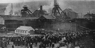
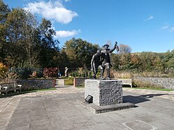
The Senghenydd colliery disaster, also known as the Senghenydd explosion, occurred at the Universal Colliery in Senghenydd, near Caerphilly, Glamorgan, Wales, on 14 October 1913. The explosion, which killed 439 miners and a rescuer, is the worst mining accident in the United Kingdom. Universal Colliery, on the South Wales Coalfield, extracted steam coal, which was much in demand. Some of the region's coal seams contained high quantities of firedamp, a highly explosive gas consisting of methane and hydrogen.

The Cathays Cemetery is one of the main cemeteries of Cardiff, Wales. It is in the Cathays district of the city, about 1.5 miles (2.4 km) north of Cardiff city centre. At 110 acres it is the third largest cemetery in the United Kingdom. It is listed on the Cadw/ICOMOS Register of Parks and Gardens of Special Historic Interest in Wales.
Llanfair Kilgeddin is a small village in Monmouthshire, south east Wales, lying within the administrative community of Llanover. It is located four miles north west of Usk and six miles south east of Abergavenny on the B4598 road. The River Usk passes close by.

Senghenydd is a former mining village in the community of Aber Valley in South Wales, approximately four miles northwest of the town of Caerphilly. Historically within the county of Glamorgan, it is now situated in the county borough of Caerphilly. In the United Kingdom Census 2001, the population of the Aber Valley was 6,696.

Universal Colliery was a coal mine located in Senghenydd in the Aber Valley, roughly four miles north-west of the town of Caerphilly. It was in the county borough of Caerphilly, traditionally in the county of Glamorgan, Wales.

The Nelson Garden, on 13 Chippenhamgate Street, at the rear of No.18 Monnow Street, Monmouth, Monmouthshire is a 19th-century garden that was the scene of a tea party held to honour Lord Nelson in 1802. The garden is one of 24 sites on the Monmouth Heritage Trail. It is bounded on the south by the line of the medieval town wall through which it is entered via a short underground passageway. The garden has limited public access and is now managed by a trust. It is included on the Cadw/ICOMOS Register of Parks and Gardens of Special Historic Interest in Wales.

Rhondda Cynon Taf is a county borough in South Wales. It is located to the north-west of Cardiff and covers an area of 424 km2 (164 sq mi). In 2021 the population was approximately 237,500.

Rhondda Cynon Taf is a county borough in South Wales. It is located to the north-west of Cardiff and covers an area of 424 km2 (164 sq mi). In 2021 the population was approximately 237,500.

Rhondda Cynon Taf is a county borough in South Wales. It is located to the north-west of Cardiff and covers an area of 424 km2 (164 sq mi). In 2021 the population was approximately 237,500.

Merthyr Tydfil County Borough is located in the historic county of Glamorgan in Wales and takes its name from its largest town. The county borough covers an area of 111 km2 (43 sq mi) and had a population of approximately 58,900 in 2021. There are three sites on the register of parks and gardens in Merthyr Tydfil County Borough. Two are listed at Grade II*, and one is Grade II.

Bridgend County Borough is a county borough in south-east Wales. It covers an area of 251 km2 (97 sq mi). In 2021 the population was approximately 145,800.

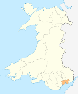
Caerphilly County Borough is a county borough in south-east Wales. It covers an area of 227 km2 (88 sq mi). In 2021 the population was approximately 176,000.

The Vale of Glamorgan is a county borough in south-east Wales. It covers an area of 331 km2 (128 sq mi) and in 2021 the population was approximately 132,500.

Neath Port Talbot is a county borough in South Wales. It covers an area of 441 km2 (170 sq mi) and in 2021 the population was approximately 141,900.

The City and County of Swansea is a principal area in south Wales. It covers an area of 380 km2 (150 sq mi) and in 2021 the population was approximately 237,800.

Carmarthenshire is a county in the south-west of Wales. It covers an area of 2,370 km2 (920 sq mi). In 2021 the population was approximately 188,200.

Ceredigion is a county in the west of Wales. It covers an area of 1,785 km2 (689 sq mi) and in 2021 the population was approximately 70,700.

Newport is a city and county borough in the south of Wales. It covers an area of 190 km2 (73 sq mi) and in 2021 the population was approximately 159,700.

Maes Manor is a country house near Blackwood, Caerphilly, Wales. It dates mainly from the early 20th century and is notable for its gardens, designed by Thomas Mawson. Now a hotel, Maes Manor is a Grade II listed building and its gardens and grounds are listed on the Cadw/ICOMOS Register of Parks and Gardens of Special Historic Interest in Wales.


