Hauraki District is a territorial authority within the Waikato Region of New Zealand. The seat of the council is at Paeroa.

Hikuai is a small community on the Tairua River towards the base of the Coromandel Peninsula in the North Island of New Zealand. It lies 40 kilometres north of Waihi and 10 kilometres southwest of Tairua, close to the junction of State Highways 25 and 25A, the latter of which is a winding road cutting across the steep Coromandel Range of hills. It is a tourist hot spot in days such as New Zealand Labour Weekend, The Christmas Holidays and especially when Tairua and Pauanui are busy.
The town of Pauanui is on the east coast of the Coromandel Peninsula in the North Island of New Zealand. It lies at the mouth of the Tairua River on its south bank, directly opposite the larger town of Tairua. The population was 750 in 2013 and 741 in the 2006 Census, an increase of 42 from 2001.

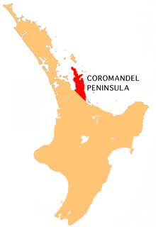
The Coromandel Range is a ridge of rugged hills running the length of the Coromandel Peninsula in the North Island of New Zealand. It is located 60 kilometres (37 mi) east of the city of Auckland, and runs north-south for approximately 85 kilometres. The highest point in the range is Mount Moehau, at the northern end of the peninsula within the Moehau Range. There are numerous peaks over 600 metres in height.
The Ohinemuri River is located in the northern half of New Zealand's North Island, at the base of the Coromandel Peninsula.

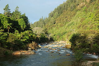
The Tairua River is located on the Coromandel Peninsula in the North Island of New Zealand.

Ngatea is a small town on the Hauraki Plains in the North Island of New Zealand. It is located 18 kilometres southwest of Thames and 70 kilometres southeast of Auckland. Ngatea lies on the Piako River, eight kilometres south of its outflow into the Firth of Thames.
Whitianga is a town on the Coromandel Peninsula, in the Waikato Region of New Zealand's North Island. The town is located on Mercury Bay, on the northeastern coast of the peninsula. The town has a permanent population of 5,080 as of June 2018, making it the second-largest town on the Coromandel Peninsula behind Thames.
Puriri is a small locality on the Hauraki Plains of New Zealand. It lies approximately 14 km south-east of Thames, New Zealand.
Hikutaia is a locality on the Hauraki Plains of New Zealand. It lies on State Highway 26, south east of Thames and north of Paeroa. The Hikutaia River runs from the Coromandel Range through the area to join the Waihou River.
The Hikutaia River is a river of New Zealand's North Island. It has its source in several streams which flow west from the Coromandel Range, the longest of which is the Waipaheke Stream. The river generally flows west, reaching its outflow into the Waihou River 10 kilometres (6 mi) north of Paeroa on the edge of the Hauraki Plains.
The Kauaeranga River is a river of New Zealand's North Island. One of the main rivers on the Coromandel Peninsula, it rises in the Coromandel Range which forms the backbone of the peninsula, flowing southwest to reach the Firth of Thames at Thames
The Komata River is a river of New Zealand's North Island. It flows west from the Coromandel Range, reaching the Waihou River just north of Paeroa.
The Opitonui River is a river of the Coromandel Peninsula in New Zealand's North Island. It flows north to reach the peninsula's east coast at Whangapoua Harbour, close to the small settlement of Te Rerenga.
The Otahu River is a river of the Coromandel Peninsula, in the Waikato Region of New Zealand's North Island. It flows generally northeast from several streams with watersheds in the Coromandel Range, most notably the Wharekirauponga Stream. The Otahu reaches the sea immediately to the south of the town of Whangamata.
The Puriri River is a river of the Waikato Region of New Zealand's North Island. It flows west close to the point where the Coromandel Peninsula joins the rest of the North Island, reaching the Waihou River 3 kilometres (2 mi) east of Turua.
The Waitekauri River is a river of the Waikato Region of New Zealand's North Island. It flows south from the Coromandel Range at the foot of the Coromandel Peninsula to reach the Ohinemuri River six kilometres west of Waihi.
The Waitekuri River is a river of the Coromandel Peninsula in New Zealand's North Island. It flows east from its sources in the Coromandel Range east of Coromandel to reach Whangapoua Harbour four kilometres south of Whangapoua.
The Wharekawa River is a river of the Coromandel Peninsula, in the Waikato Region of New Zealand's North Island. It flows northeast to reach the Wharekawa Harbour half way between Pauanui and Whangamata.