Related Research Articles

London Bridge is a central London railway terminus and connected London Underground station in Bermondsey, south-east London. It occupies a large area on three levels immediately south-east of London Bridge, from which it takes its name. The main line station is the oldest railway station in London fare zone 1 and one of the oldest in the world having opened in 1836. It is one of two main line termini in London to the south of the River Thames and is the fourth-busiest station in London, handling over 50 million passengers a year.

Blackfriars, also known as London Blackfriars, is a central London railway station and connected London Underground station in the City of London. It provides Thameslink services: local, and regional and limited Southeastern commuter services to South East London and Kent. Its platforms span the River Thames, the only one in London to do so, along the length of Blackfriars Railway Bridge, a short distance downstream from Blackfriars Bridge. There are two station entrances either side of the Thames, along with a connection to the London Underground District and Circle lines.

The East Coast Railway is one of the 19 railway zones of Indian Railways. It came into existence on 1 April 2003. The headquarters of the zone are at Bhubaneswar, Odisha.
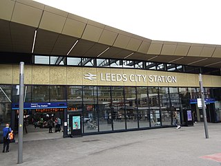
Leeds railway station is the mainline railway station serving the city centre of Leeds in West Yorkshire, England. It is located on New Station Street to the south of City Square, at the foot of Park Row, behind the landmark Queens Hotel. It is one of 20 stations managed by Network Rail. As of December 2023, it was the busiest station in West Yorkshire, as well as in Yorkshire & the Humber, and the entirety of Northern England. It is the second busiest station in the UK outside of London, after Birmingham New Street.

Beijingxi railway station, colloquially referred to as West Station, is located in western Beijing's Fengtai District. Opened in early 1996 after three years of construction, it was the largest railway station in Asia with an area of 510,000 m2 (5,500,000 sq ft), before being surpassed by Shanghai Hongqiao railway station in platform capacity. The station serves in average 150,000–180,000 passengers per day with a maximum of 400,000 people per day. It was expanded during the 2000s decade, during which several platforms were added. It also has a fairly large number of car-parking spaces.

Howrah railway station is a railway station located in the city of Howrah, West Bengal at Kolkata metropolitan region,India. It is the largest and busiest railway complex in India, as well as one of the busiest and largest train stations in the world. It is also the oldest surviving railway complex in India. Howrah is one of the five large intercity main stations serving the Kolkata metropolitan area, the others being Sealdah, Santragachi, Shalimar and Kolkata railway station.

Shanghai railway station is one of the four major railway stations in Shanghai, China, the others being Shanghai South, Shanghai Hongqiao, and Shanghai West (Shanghaixi).

Werris Creek is a small town in New South Wales, Australia, near Tamworth, in Liverpool Plains Shire. It is north of Quirindi and is at the junction of the Main North railway line to Armidale and Moree. At the 2011 census, Werris Creek had a population of 1,437.
The Kolkata Suburban Railway is a set of suburban and regional rail services serving the Kolkata metropolitan area and its surroundings in India. It is the largest suburban railway network in the country by number of stations and track length, and also one of the largest in the world. There are five main lines and nineteen branch lines. It operates more than 1,500 services, carrying 3.5 million people daily and 1.2 billion people every year. It runs from 03:00 am until 02:00 am and fares range from Rs.5 to Rs.25. The system uses 25 kV 50 Hz AC power supply and runs on 5 ft 6 in broad gauge track. It has interchange stations with the Kolkata Metro at various locations.

Beijingnan railway station is a large railway station in Fengtai District, Beijing, about 7.5 km (4.7 mi) south of central Beijing, between the 2nd and 3rd ring roads. The station in its present form opened on 1 August 2008 and mainly serves high speed trains.

Bangalore City Railway Station, officially Krantivira Sangolli Rayanna Bengaluru Station, commonly known as KSR Bengaluru Station, Bengaluru City Railway Station or Majestic Railway station, is the main railway station serving the city of Bangalore, Karnataka, India. It is the busiest railway station in South Western Railway zone of Indian Railways, and is the only station classified under NSG1 category in the zone.
John Brown was a New Zealand cyclist who won a silver medal at the 1938 British Empire Games.

A train station, railroad station, or railroad depot and railway station is a railway facility where trains stop to load or unload passengers, freight, or both. It generally consists of at least one platform, one track, and a station building providing such ancillary services as ticket sales, waiting rooms, and baggage/freight service. Stations on a single-track line often have a passing loop to accommodate trains travelling in the opposite direction.

Nanjingnan railway station is a high-speed railway station in Nanjing, the capital of Jiangsu province, serving the Beijing–Shanghai (Jinghu) high-speed railway, Shanghai–Nanjing (Huning) intercity railway, Nanjing–Hangzhou (Ninghang) high-speed railway, Shanghai–Wuhan–Chengdu (Huhanrong) high-speed railway and the South Jiangsu Riverside high-speed railway. The new Nanjing South railway station is located a few kilometers south of downtown Nanjing in Yuhuatai District, and has a connection with the Nanjing Metro, served by Lines 1, 3, S1 and S3. Construction on the station began on 10 January 2008, and the station opened on 28 June 2011, two days before the opening of the Beijing–Shanghai high-speed railway.

Yesvantpur Junction railway station also Yeshwanthapura Junction railway station is one of the three important stations which serves the city of Bangalore which is located in Yesvantpur locality. It is one of the developing stations of Bangalore created for reducing the rush at Bangalore City railway station.

Royapuram railway station is a railway station at Royapuram, on the Chennai Beach–Walajapet section of the Chennai Suburban Railway network in Chennai, India. It is the second oldest railway station currently operational in India after Howrah railway station situated in Howrah, West Bengal and the first railway station of South India. The first train of South India started operating in June 1856 from Royapuram railway station. The station also remained the headquarters of the Madras and Southern Mahratta Railway till 1922, when the headquarters was shifted to Egmore. Since the original structures of Bombay and Thane stations no longer exist, Royapuram station remains the oldest railway station in the entire subcontinent.

Chennai, the capital city of the state of Tamil Nadu, India, and the headquarters of the Southern Railway zone, is a major rail transport hub in the country. It has over 40 railway stations which are part of an extensive suburban railway network The city is served by three railway terminals – the Puratchi Thalaivar Dr. M.G. Ramachandran Central Railway Station and the Chennai Egmore railway station and the Tambaram railway station.
References
- ↑ Werai station. NSWrail.net. Accessed 9 August 2009.
| | This article about a railway station in New South Wales is a stub. You can help Wikipedia by expanding it. |