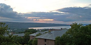
Cayuga Lake is the longest of central New York's glacial Finger Lakes, and is the second largest in surface area and second largest in volume. It is just under 40 miles (64 km) long. Its average width is 1.7 miles (2.7 km), and it is 3.5 mi wide (5.6 km) at its widest point near Aurora. It is approximately 435 ft deep (133 m) at its deepest point.

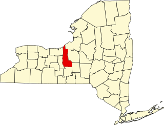
Cayuga County is a county in the U.S. state of New York. As of the 2010 census, the population was 80,026. Its county seat is Auburn. The county was named for one of the tribes of Indians in the Iroquois Confederation.
West Branch may refer to:
This is a list of trails in Ithaca, New York.

Cayuga Creek is a small stream in western New York, United States, with stretches in both Erie County and Wyoming County. The creek enters Buffalo Creek in the northwest corner of the Town of West Seneca in Erie County, just upstream from the New York State Thruway crossing. At that point, Buffalo Creek becomes the Buffalo River and flows into Lake Erie near Buffalo, New York.
List of the National Register of Historic Places listings in Cayuga County, New York:

New York State Route 38 (NY 38) is a north–south state highway in the Finger Lakes region of New York in the United States. Its southern terminus is at an intersection with NY 96 in the town of Owego in Tioga County. The northern terminus is at a junction with NY 104A in the town of Sterling in Cayuga County. NY 38 is a two-lane local road for most of its length. The route is the main access road to parts of Auburn, Dryden, Newark Valley and Port Byron. It passes through mountainous terrain in Tioga and Cortland counties, but the terrain levels out as it heads through the Finger Lakes area and Cayuga County.
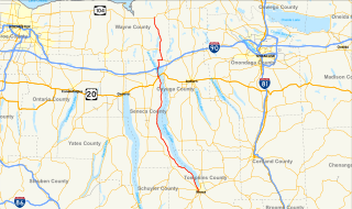
New York State Route 89 (NY 89) is a north–south state highway in central New York in the United States. It extends for 62.35 miles (100.34 km) from an intersection with NY 13, NY 34, and NY 96 in the Tompkins County city of Ithaca to an interchange with NY 104 in the Wayne County town of Wolcott. The route spans a total of three counties, connecting the heart of the Finger Lakes Region to a point 6 miles (10 km) south of Lake Ontario. Along the way, NY 89 intersects two regionally important highways: the conjoined routes of U.S. Route 20 (US 20) and NY 5 in Seneca Falls and NY 31 in Savannah. NY 89 runs along the western edge of Cayuga Lake from Ithaca to Seneca Falls.
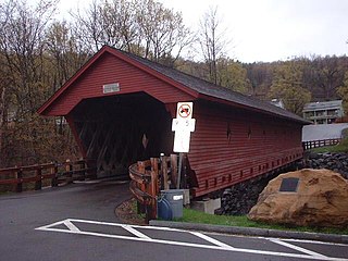
Newfield Bridge is a wooden covered bridge over the Cayuga Inlet west branch. It is in Newfield, Tompkins County, New York. It is one of 29 covered bridges in New York State and the oldest covered bridge in New York that continues to carry motor vehicle traffic.
Owasco Inlet is a river located in Cayuga County, New York. It starts at an unnamed marsh north of Freeville, New York and flows north before emptying into Owasco Lake.
Mill Creek is a river located in Cayuga County, New York. It flows into Owasco Inlet by Moravia, New York.
Hemlock Creek is a river located in Cayuga and Tompkins counties. It flows into Owasco Inlet by Locke, New York.

Cascadilla Creek is a river located in Tompkins County, New York. It flows into Cayuga Inlet by Ithaca, New York.
Buttermilk Creek is a river located in Tompkins County, New York. It flows into Cayuga Inlet by Ithaca, New York.
Lick Brook is a river located in Tompkins County, New York. It flows into Cayuga Inlet south of Ithaca, New York.
Cliff Park Brook is a river located in Tompkins County, New York. It flows into Cayuga Inlet by Ithaca, New York.
Coy Glen is a river located in Tompkins County, New York. It flows into Cayuga Inlet by Ithaca, New York.
Enfield Creek is a river located in Tompkins County, New York. It flows into Cayuga Inlet by Ithaca, New York.
