
Pelham is a suburban town in Westchester County, approximately 10 miles northeast of Midtown Manhattan. As of the 2020 census, it had a population of 13,078, an increase from the 2010 census. Historically, Pelham was composed of five villages and became known as "the Pelhams". Pelham currently contains two independently incorporated villages: the Villages of Pelham and Pelham Manor.

Columbia Island, is an island in the Long Island Sound and part of New Rochelle, New York. It is situated off the south-eastern coast of Davids Island, immediately adjacent to Pea Island. Before sea walls and other structures were built on the island, the exposed rock varied in size from about one acre to 175 square feet depending on the tide.
The West Bronx is a region in the New York City borough of the Bronx. The region lies west of the Bronx River and roughly corresponds to the western half of the borough.

The New York, Westchester and Boston Railway Company, was an electric commuter railroad in the Bronx and Westchester County, New York from 1912 to 1937. It ran from the southernmost part of the South Bronx, near the Harlem River, to Mount Vernon with branches north to White Plains and east to Port Chester. From 1906, construction and operation was under the control of the New York, New Haven & Hartford Railroad (NH) until its bankruptcy in 1935.
Wingate is a neighborhood in the north central portion of the New York City borough of Brooklyn. The area is bordered by Prospect Lefferts Gardens to the west, Crown Heights to the north and east, and East Flatbush to the south. Wingate is bounded by Empire Boulevard to the north, Troy Avenue to the east, Winthrop Street to the south, and New York Avenue to the west. The area is part of Brooklyn Community District 9. It is sometimes considered part of Crown Heights, East Flatbush, and/or Prospect Lefferts Gardens.
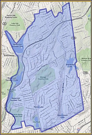
Wykagyl is a suburban community in New Rochelle, Westchester County, New York, United States. It is conterminous with ZIP code 10804, encompassing much of the city's 'North End'. According to Forbes, in 2010 Wykagyl's 10804 ZIP code, with a median home price of $806,264, ranked 333rd on its list of the 500 most expensive ZIP codes in the U.S. The Washington Post ranks Wykagyl among the nation's 650 Super Zips, or those with the highest percentile rankings for median household income and the share of adults with college degrees or higher.
Centre Market Place is a one block long street in Lower Manhattan, New York City, bordering Mulberry Street to the east, Grand Street to the south, Broome Street to the north, and Centre Street to the west. Centre Market Place was originally an extension of Orange Street, before being formally renamed Centre Market Place in April 1837, after Centre Market, which was west of the street. At one time, the street was at the top of a high hill. Currently, local residents consider Centre Market Place to be part of the NoLIta neighborhood. At the southern end of the street, on the corner of Grand Street, is Onieal's restaurant, which features a cavernous wine cellar that once served as a speakeasy during Prohibition. Gentlemen of means would walk through the front of the Police Building, perhaps make a contribution to the "widows and orphan fund" and then walk through the cellar corridor connecting the two buildings.
The Thomas Paine Historical Association is an organization based in New Rochelle, New York, that is dedicated to perpetuating the legacy of Founding Father Thomas Paine. It was organized on the anniversary of Paine's birthday, January 29, 1884, and is one of the oldest historical associations in the United States. It is one of two Thomas Paine legacy organizations based in New Rochelle, the other being the Thomas Paine Cottage Museum of the Huguenot and New Rochelle Historical Society, founded in 1886, which owns and maintains the Thomas Paine Cottage.
Neptune Island is an island in Long Island Sound and part of the City of New Rochelle, New York. It is connected to the mainland by a stone causeway topped by Neptune Road. A dam at the peninsula's east end creates a small pond, and its west shore edges the Neptune Basin inlet.
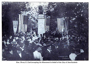
The Thomas Paine Monument is a bronze sculpture located in New Rochelle, New York, dedicated to perpetuating the legacy of Founding Father Thomas Paine. The monument stands on North Avenue at the entrance to Paine Avenue, between the Thomas Paine National Historical Association to the north and the property of the Huguenot and Historical Association of New Rochelle to the south. This is the oldest extant memorial to Thomas Paine. The original monument erected in 1839 consisted of just a tapered marble pedestal and decorative cap. A bronze bust of Paine was later added in 1899.

All View is a historic, 28 room estate home located on the Long Island Sound shore in the gated, Premium Point community of New Rochelle, in Westchester County, New York. Although real estate advertisements have listed the architect as Stanford White, the actual designer was Sidney Vanuxem Stratton, who maintained an office in the same building as McKim, Mead & White. It sits on 2.82 acres at the end of the Premium Point peninsula overlooking New Rochelle's upper most harbor, Echo Bay.
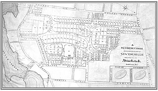
Residence Park is a historic community located in the city of New Rochelle, in Westchester County, New York. It is one of the first planned residential parks, and garden city communities, in the United States. It is located in the southern section of the city, bordered by Neptune Park on the west, Shore Road and Long Island Sound on the south, and Downtown New Rochelle on the north.
Sutton Manor is a distinctive early 20th century suburban residential district in the city of New Rochelle in Westchester County, New York. The neighborhood is located off the northern shore of Long Island Sound on Echo Bay. It was developed as an upper middle class enclave for families with heads of households employed in New York City and served as a model for the ideal suburban setting; harmonious architecture and exclusive amenities. The development appears to have been modeled on neighboring Larchmont Manor in the Town of Mamaroneck, yet on a smaller scale. That subdivision was conceived originally as an exclusive and convenient seasonal playground for New York’s wealthy upper classes, with its 6-acre waterfront park.
Cooper's Corners is a historic section of the city of New Rochelle in Westchester County, New York. For over two centuries Cooper's Corners served as an outpost for residents who lived in rural 'Upper New Rochelle', an area miles from the business center of town.
Titus Mill Pond & New York State Tidal Wetlands is located at the northeastern end of New Rochelle Harbor in the city of New Rochelle in Westchester, New York. The waters in the harbor and pond flow from Long Island Sound, with tides up to eight feet in the inlet and with no fresh water stream entering into it.
Davenport Neck is a peninsula in New Rochelle, New York, extending southwesterly from the mainland into Long Island Sound, and running parallel to the main shore. It divides the city's waterfront into two, with New Rochelle Harbor to the south and southwest, and Echo Bay, to the north and northeast. Glen Island and Neptune Island lie just to the west of the Neck, and Davids and Huckleberry islands lie to the south.
New Rochelle Public Library (NRPL) is a public library located in New Rochelle, New York. Chartered in 1894, the NRPL is a school-district library with its own operating budget and a board of trustees with seven elected members. The library has served the residents of New Rochelle from its main library building in the downtown business district since 1979.
Reservoir 3 is a man-made reservoir located in the northern portion of the city of New Rochelle along the New Rochelle - Eastchester boundary in Westchester County, New York. Constructed in 1908, the reservoir is impounded by the New Rochelle "Reservoir 3 dam" on the Hutchinson River. The dam is of earthen construction, with a height of 30 feet (9.1 m) and a length of 450 feet (140 m). It has an area of about 30 acres (12 ha), and a capacity of about 128 million US gallons (480,000 m3). Maximum discharge is 1,815 cubic feet (51.4 m3) per second. Its capacity is 498 acre-feet (614,000 m3). Normal storage is 220 acre-feet (270,000 m3). It drains an area of 2.85 square miles (7.4 km2). The reservoir is currently owned by the Westchester County Department of Parks and Recreation.