Related Research Articles

Drysdale River National Park is a national park in the Kimberley region of Western Australia, 2,168 kilometres (1,347 mi) northeast of Perth.

The Purnululu National Park is a World Heritage Site in the East Kimberley region of Western Australia. The 239,723-hectare (592,370-acre) national park is located approximately 300 kilometres (190 mi) south of Kununurra, with Halls Creek located to the south. Declared a World Heritage Site in 2003, the park was inscribed as follows:
...[is a] remote area managed as wilderness. It includes the Bungle Bungle Range, a spectacularly incised landscape of sculptured rocks which contains superlative examples of beehive-shaped karst sandstone rising 250 metres above the surrounding semi-arid savannah grasslands. Unique depositional processes and weathering have given these towers their spectacular black and orange banded appearance, formed by biological processes of cyanobacteria which serve to stabilise and protect the ancient sandstone formations. These outstanding examples of cone karst that have eroded over a period of 20 million years are of great beauty and exceptional geological interest.

The Kimberley is the northernmost of the nine regions of Western Australia. It is bordered on the west by the Indian Ocean, on the north by the Timor Sea, on the south by the Great Sandy and Tanami deserts in the region of the Pilbara, and on the east by the Northern Territory.
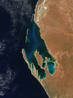
Shark Bay is a World Heritage Site in the Gascoyne region of Western Australia. The 23,000-square-kilometre (8,900 sq mi) area is located approximately 800 kilometres (500 mi) north of Perth, on the westernmost point of the Australian continent. UNESCO's official listing of Shark Bay as a World Heritage Site reads:
The Pilbara is a large, dry, thinly populated region in the north of Western Australia. It is known for its Aboriginal peoples; its ancient landscapes; the red earth; and its vast mineral deposits, in particular iron ore. It is also a global biodiversity hotspot for subterranean fauna.

Greater Western Sydney (GWS) is a large region of the metropolitan area of Greater Sydney, New South Wales, Australia that generally embraces the north-west, south-west, central-west, and far western sub-regions within Sydney's metropolitan area and encompasses 13 local government areas: Blacktown, Canterbury-Bankstown, Camden, Campbelltown, Cumberland, Fairfield, Hawkesbury, Hills Shire, Liverpool, Parramatta, Penrith, Wollondilly and the western portion of the City of Parramatta Council. It includes Western Sydney, which has a number of different definitions, although the one consistently used is the region composed of ten local government authorities, most which are members of the Western Sydney Regional Organisation of Councils (WSROC). Penrith, Hills Shire & Canterbury-Bankstown are not WSROC members. The NSW Government's Office of Western Sydney uses the broader Greater Western Sydney definition to refer to the region.

The Ord River is a 651 km long river in the Kimberley region of Western Australia. The river's catchment covers 55,100 square kilometres (21,274 sq mi).

The Fitzroy River is located in the West Kimberley region of Western Australia. It has 20 tributaries and its catchment occupies an area of 93,829 square kilometres (36,228 sq mi), within the Canning Basin and the Timor Sea drainage division.

The Ningaloo Coast is a World Heritage Site located in the north west coastal region of Western Australia. The 705,015-hectare (1,742,130-acre) heritage-listed area is located approximately 1,200 kilometres (750 mi) north of Perth, along the East Indian Ocean. The distinctive Ningaloo Reef that fringes the Ningaloo Coast is 260 kilometres (160 mi) long and is Australia's largest fringing coral reef and the only large reef positioned very close to a landmass. The Muiron Islands and Cape Farquhar are within this coastal zone.

Kingscote is a town in the Australian state of South Australia located on Kangaroo Island about 119 kilometres (74 mi) south-west of the state capital of Adelaide. It is South Australia's oldest European settlement and the island's largest town. At the 2016 census, Kingscote had a population of 1,790. It is a well-established tourist centre and the administrative and communications centre. It is home to a colony of the smallest penguins in the world, the little penguin.

The Shire of Derby-West Kimberley is one of four local government areas in the Kimberley Region of northern Western Australia, covering an area of 104,080 square kilometres (40,186 sq mi), most of which is sparsely populated. The Shire's population as at the 2016 Census was almost 8,000, with most residing in the major towns of Derby, which is also the Shire's seat of government, and Fitzroy Crossing. There are also around 70 Aboriginal communities within the Shire.

Enoggera is a suburb of the City of Brisbane, in Queensland, Australia.
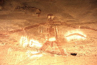
An Australian Aboriginal sacred site is a place deemed significant and meaningful by Aboriginal Australians based on their beliefs. It may include any feature in the landscape, and in coastal areas, these may lie underwater. The site's status is derived from an association with some aspect of social and cultural tradition, which is related to ancestral beings, collectively known as Dreamtime, who created both physical and social aspects of the world. The site may have its access restricted based on gender, clan or other Aboriginal grouping, or other factors.

The King George River is a perennial river located in the Kimberley region of Western Australia, in Australia.

Australian Convict Sites is a World Heritage property consisting of 11 remnant penal sites originally built within the British Empire during the 18th and 19th centuries on fertile Australian coastal strips at Sydney, Tasmania, Norfolk Island, and Fremantle; now representing "...the best surviving examples of large-scale convict transportation and the colonial expansion of European powers through the presence and labour of convicts."

Fossil Downs Station is a pastoral lease and cattle station located about 50 kilometres (31 mi) North East of Fitzroy Crossing in the Kimberley region of Western Australia.
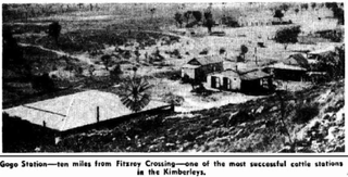
Gogo or Gogo Station and sometimes referred to as Margaret Downs is a pastoral lease that has operated as a cattle station. It is located about 11 kilometres (7 mi) south of Fitzroy Crossing and 83 kilometres (52 mi) north east of Yungngora in the Kimberley region of Western Australia,

Mount Hart Station, commonly referred to as Mount Hart, is a defunct pastoral lease that once operated as a cattle station in Western Australia. The lands are part of a conservation area and the homestead operates as a wilderness lodge for tourists.
Kimberley Downs Station, commonly referred to as Kimberley Downs, is a pastoral lease that operates as a cattle station in Western Australia.
Roebuck Plains Station is a pastoral lease that is located close to the township of Broome in the Kimberley region of Western Australia. It is one of the closest pastoral leases to Broome.
References
- ↑ "Environment Protection and Biodiversity Conservation Act 1999 : Inclusion of a Place in the National Heritage List : The West Kimberley". Commonwealth Of Australia Gazette. Special (S132). Australia. 31 August 2011. p. 1. Retrieved 3 December 2018– via National Library of Australia.
- ↑ Australia. Department of Sustainability, Environment, Water, Population and Communities (2011), One place, many stories : West Kimberley National Heritage listing, Dept of Sustainability, Environment, Water, Population and Communities, ISBN 978-1-921733-30-7 CS1 maint: multiple names: authors list (link)
- ↑ "The West Kimberley (Place ID 106063)". Australian Heritage Database . Department of the Environment . Retrieved 13 October 2018.
- ↑ "Derby News". Northern Times . XXII (1118). Western Australia. 20 August 1927. p. 8. Retrieved 3 December 2018– via National Library of Australia.
| | This article about a location in Western Australia is a stub. You can help Wikipedia by expanding it. |