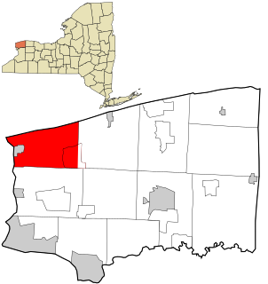
Porter is a town in Niagara County, New York, United States. The population was 6,771 at the 2010 census. The town was named after Judge Augustus Porter.

Somerset is a town in Niagara County, New York, United States. The population was 2,662 at the 2010 census. The town is believed to be named after Somerset, New Jersey, the source of some early settlers.
Rushville is a village in Ontario and Yates Counties in the U.S. state of New York. The population was 655 in the 2019 American Community Survey. Most of the Village of Rushville is within the Town of Potter in Yates County and a small part is in the Town of Gorham in Ontario County. It is one of two villages in Ontario County that is split between two townships and the only village in Ontario split between two counties.

Bergen is a village in Genesee County, New York, United States. The population was 1,176 at the 2010 census.

The Rush–Bagot Treaty or Rush–Bagot Disarmament was a treaty between the United States and Great Britain limiting naval armaments on the Great Lakes and Lake Champlain, following the War of 1812. It was ratified by the United States Senate on April 16, 1818, and was confirmed by Canada, following Confederation in 1867.

Central Frontenac is a township in eastern Ontario, Canada in the County of Frontenac.
Honeoye Lake Boat Launch State Park is a nine-acre (3.6 ha) state park located along the southeastern shore of Honeoye Lake, one of New York's Finger Lakes. The park is located in Ontario County off East Lake Road, and offers a boat launch in addition to facilitating lake access for fishing and ice fishing.

Brampton North is a provincial electoral district in Ontario. It was originally created prior to the 1987 election from part of Brampton. It existed for the 1987, 1990, and 1995 elections. It was abolished in 1999 into Bramalea—Gore—Malton—Springdale, Brampton Centre, Brampton West—Mississauga. For the 2018 election, it was re-created from Bramalea—Gore—Malton, Brampton—Springdale, and Brampton West.
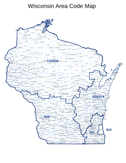
North American telephone area code 262 covers much of Southeastern Wisconsin, and was created on September 25, 1999, when it was split from area code 414. It covers most of the suburbs of Milwaukee, but not Milwaukee County itself.
Ontario Center is a hamlet in the Town of Ontario, Wayne County, New York, United States. It is located one mile (2 km) west-northwest of the hamlet of Ontario, at an elevation of 449 feet. The primary intersection in the hamlet is at N.Y. Route 350 and Ridge Road. N.Y. Route 104 passes just north of Ontario Center.

Charlotte is a neighborhood in Rochester in the U.S. state of New York, located along the western bank of the mouth of the Genesee River along Lake Ontario. It is the home of the Port of Rochester and Charlotte High School.

Cherry Valley is a community in the single-tier municipality of Prince Edward County, Ontario, Canada. It is located at 43°56.16′N77°9.23′W. Located on Lake Ontario within Quinte on the shores of Lake Ontario, the Salmon Point Lighthouse was erected in Cherry Valley in 1871, when the area was already nicknamed Wicked point by sailors. The lighthouse remained working for about sixty years. Its function was replaced by the Point Petre Lighthouse built in 1833.

Sudbury is a provincial electoral district in Ontario, Canada, that has been represented in the Legislative Assembly of Ontario since 1908. It is one of the two districts serving the city of Greater Sudbury.
Milford is a town in the single-tier municipality of Prince Edward County, Ontario, Canada. It is located at 43°56.5′N77°5.25′W. Located on the Black River, Milford was founded in 1808 and was a busy timber milling center until approximately 1900 and was the capital of Marysburgh Township before township restructuring and ultimately amalgamation into Prince Edward County.
Western Hill is a community in the city of St. Catharines, Ontario, Canada. It borders highway 406 to the north, Regional Road 72 to the south, the Twelve Mile Creek to the east, and Louth St to the west,.
Haig is a community in the city of St. Catharines, Ontario, Canada. Its borders are Regional Road 83 to the north, Regional Road 77 to the south, Lake Street to the east, and the Twelve Mile Creek to the west.

Brampton North is a federal electoral district in Ontario, Canada. It encompass portions of Ontario formerly included in the electoral districts of Brampton—Springdale, Bramalea—Gore—Malton and Brampton West.

Scotch Bonnet Island is a small island in Lake Ontario. It is part of Prince Edward County, Ontario, Canada.
Nicholson Island is a small island in Lake Ontario about 3 kilometres (1.9 mi) west of Prince Edward County, Ontario. It is one of the islands and shoals in the Scotch Bonnet Ridge.

The Grand View Beach Railway was a scenic electric street railway along the shore of Lake Ontario from the village of Ontario Beach, a suburb of Rochester, to Manitou Beach.
