Lulworth is the popular name for an area on the coast of Dorset, South West England notable for its castle and cove. However, there is no actual place or feature called simply "Lulworth", the villages are East and West Lulworth and the coastal feature is Lulworth Cove.

Durdle Door is a natural limestone arch on the Jurassic Coast near Lulworth in Dorset, England. Although privately owned by the Lulworth Estate, it is open to the public.

Purbeck was a local government district in Dorset, England. The district was named after the Isle of Purbeck, a peninsula that forms a large proportion of the district's area. However, it extended significantly further north and west than the traditional boundary of the Isle of Purbeck which is the River Frome. The district council was based in the town of Wareham, which is itself north of the Frome.

The Purbeck Hills, also called the Purbeck Ridge or simply the Purbecks, are a ridge of chalk downs in Dorset, England. It is formed by the structure known as the Purbeck Monocline. The ridge extends from Lulworth Cove in the west to Old Harry Rocks in the east, where it meets the sea. The hills are part of a system of chalk downlands in southern England formed from the Chalk Group which also includes Salisbury Plain and the South Downs. For most of their length the chalk of the Purbeck Hills is protected from coastal erosion by a band of resistant Portland limestone. Where this band ends, at Durlston Head, the clay and chalk behind has been eroded, creating Poole Bay and the Solent. The ridge of steeply dipping chalk that forms the Purbeck Hills continues further east on the Isle of Wight.

Stair Hole is a small cove located just west of Lulworth Cove in Dorset, southern England. The folded limestone strata known as the Lulworth crumple are particularly visible at Stair Hole. There are several caves visible from the seaward side of Stair Hole; Cathedral Cavern is supported by pillars of rock rising out of the water. The rock structure was created during the Alpine orogeny and exposed by subsequent erosion.
The Lulworth Estate is located in central south Dorset, England. Its most notable landscape feature include a five-mile stretch of coastline on the Jurassic Coast. Part of the area is a World Heritage Site.

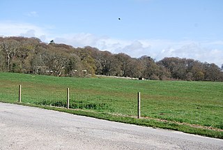
Bindon Hill is an extensive Iron Age earthwork enclosing a coastal hill area on the Jurassic Coast near Lulworth Cove in Dorset, England, about 19 kilometres (12 mi) west of Swanage, about 6 kilometres (3.7 mi) south west of Wareham, and about 17 kilometres (11 mi) south east of Dorchester. It is within an Area of Outstanding Natural Beauty.

Mupe Bay is a bay with a shingle beach to the east of Lulworth Cove in Dorset, England, and is part of the Jurassic Coast World Heritage Site.

Swyre Head, Lulworth is a hill and sea cliff which lies on the Jurassic Coast between Bat's Head to the west and Durdle Door to the east, close to Lulworth in Dorset, England. It is located approximately 8 miles (12.9 km) east of Weymouth and 14 miles (22.5 km) west of Swanage.
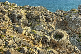
The Fossil Forest is the remains of an ancient submerged forest from Jurassic times, located to the east of Lulworth Cove on the Isle of Purbeck in Dorset, England. It lies on the Jurassic Coast, on a wide ledge in the seaside cliff. The site is within the Lulworth Ranges and thus has restricted access. Parts of forest can also be seen on the Isle of Portland and in quarries near the town of Weymouth to the west.

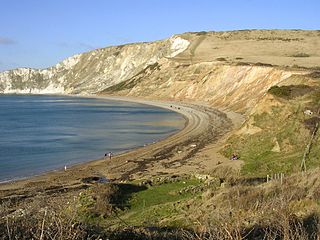
St Oswald's Bay is located near Lulworth on the Jurassic Coast in Dorset, England.

Dungy Head is a coastal promontory located west of Lulworth Cove on the Jurassic Coast in Dorset, England. It forms the eastern end of St Oswald's Bay. It is composed of Portland stone strata. The surrounding area is popular for coastal walks, which yield impressive views. Cliff-climbing however is dangerous and not recommended.

Hambury Tout is a large chalk hill by the coast near Lulworth, Dorset, England. It overlooks Lulworth Cove to the west. Hambury Tout is the site of an ancient burial mound.
Atherington Priory was a priory in West Sussex, England.
Lyminster Priory was a priory in Lyminster, West Sussex, England. It was a possible Saxon royal minster of Benedictine nuns and was founded or refounded about 1082AD by Roger de Montgomery, Earl of Sussex, who granted land to St. Peter's Abbey, Almenesches. The Priory was dissolved in about 1414AD and is now the Parish Church of St Mary Magdalene.
Sele Priory was a medieval monastic house in Upper Beeding, West Sussex, England.
Flower’s Barrow is an Iron Age hillfort, built over 2500 years ago, above Worbarrow Bay in Dorset on the south coast of England.

Brandy Bay is a small secluded southwest-facing bay, with an oil shale and shingle beach immediately below Gad Cliff and Tyneham Cap, to the east of Worbarrow Bay and to the west of Hobarrow Bay on the south coast of the Isle of Purbeck, in Dorset, England.

Hobarrow Bay is a small secluded southwest-facing bay, with an oil shale and shingle beach to the southeast of Brandy Bay and to the southwest of Kimmeridge on the south coast of the Isle of Purbeck, in Dorset, England.

Arish Mell is a small embayment and beach between Mupe and Worbarrow Bays in Dorset, England and is part of the Jurassic Coast and the South West Coast Path passes just to the north. It is about 1 mile (1.6 km) due south of Lulworth Castle and East Lulworth. The bay is relatively inaccessible because it is within the Lulworth Ranges, an Army tank firing range, and although the Range Walks are open at most weekends and public holidays, there is no public access to the beach and cliffs.
Coordinates: 50°37′06″N2°14′29″W / 50.618239°N 2.241348°W
| | This article about a British Christian monastery, abbey, priory or other religious house is a stub. You can help Wikipedia by expanding it. |