Papua is a province of Indonesia, comprising the northern coast of Western New Guinea together with island groups in Cenderawasih Bay to the west. It roughly follows the borders of Papuan customary region of Tabi Saireri. It is bordered by the sovereign state of Papua New Guinea to the east, the Pacific Ocean to the north, Cenderawasih Bay to the west, and the provinces of Central Papua and Highland Papua to the south. The province also shares maritime boundaries with Palau in the Pacific. Following the splitting off of twenty regencies to create the three new provinces of Central Papua, Highland Papua, and South Papua on 30 June 2022, the residual province is divided into eight regencies (kabupaten) and one city (kota), the latter being the provincial capital of Jayapura. The province has a large potential in natural resources, such as gold, nickel, petroleum, etc. Papua, along with five other Papuan provinces, has a higher degree of autonomy level compared to other Indonesian provinces.

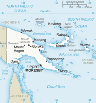
The geography of Papua New Guinea describes the eastern half of the island of New Guinea, the islands of New Ireland, New Britain and Bougainville, and smaller nearby islands. Together these make up the nation of Papua New Guinea in tropical Oceania, located in the western edge of the Pacific Ocean.

Dutch New Guinea or Netherlands New Guinea was the western half of the island of New Guinea that was a part of the Dutch East Indies until 1949, later an overseas territory of the Kingdom of the Netherlands from 1949 to 1962. It contained what are now Indonesia's five easternmost provinces, Central Papua, Highland Papua, Papua, South Papua, and West Papua, which were administered as a single province prior to 2003 under the name Irian Jaya, and now comprise the Papua region of the country.
Guinea or Guinea-Conakry is a republic in West Africa, independent since 1958.

West Papua, formerly Irian Jaya Barat, is a province of Indonesia. It covers the two western peninsulas of the island of New Guinea, the eastern half of the Bird's Head Peninsula and the Bomberai Peninsula, along with nearby smaller islands. The province is bordered to the north by the Pacific Ocean, to the west by the Halmahera Sea and the Ceram Sea, to the south by the Banda Sea, and to the east by the province of Central Papua and the Cenderawasih Bay. Manokwari is the province's capital and largest city. West Papua is the second-least populous province in Indonesia. It had a population of 1,134,068 at the 2020 Census, and the official estimate for mid 2021 was 1,156,840. However the total area and population will be reduced by the Parliamentary decision on 17 November 2022 to create a 38th province of Indonesia, comprising Sorong city and the regencies of Sorong, South Sorong, Raja Ampat, Maybrat and Tambrauw. The reduced West Papua Province will thus have a mid-2021 population estimated at only 551,791.
Papua most commonly refers to:

The indigenous peoples of Western New Guinea in Indonesia and Papua New Guinea, commonly called Papuans, are Melanesians. There is genetic evidence for two major historical lineages in New Guinea and neighboring islands: a first wave from the Malay Archipelago perhaps 50,000 years ago when New Guinea and Australia were a single landmass called Sahul and, much later, a wave of Austronesian people from the north who introduced Austronesian languages and pigs about 3,500 years ago. They also left a small but significant genetic trace in many coastal Papuan peoples.

Western New Guinea, also known as Papua, Indonesian New Guinea, or Indonesian Papua, is the western, Indonesian half of the island of New Guinea. Since the island is alternatively named as Papua, the region is also called West Papua.

The South Halmahera–West New Guinea (SHWNG) languages are a branch of the Malayo-Polynesian languages, found in the islands and along the shores of the Halmahera Sea in the Indonesian province of North Maluku and of Cenderawasih Bay in the provinces of Papua and West Papua. There are 38 languages.

The Bird's Head Peninsula or Doberai Peninsula, is a large peninsula that makes up the northwest portion of the island of New Guinea, comprising the Indonesian provinces of Southwest Papua and West Papua. The peninsula just to the south is called the Bomberai Peninsula, while the peninsula at the opposite end of the island is called the Bird's Tail Peninsula.

Sorong is the largest city and the capital of the Indonesian province of Southwest Papua. The city is located on the western tip of the island of New Guinea with its only land borders being with Sorong Regency. It is the gateway to Indonesia's Raja Ampat Islands, species rich coral reef islands in an area considered the heart of the world's coral reef biodiversity. It also is the logistics hub for Indonesia's thriving eastern oil and gas frontier. Sorong has experienced exponential growth since 2010, and further growth is anticipated as Sorong becomes linked by road to other frontier towns in Papua's Bird's Head Peninsula. The city had a population of 190,625 at the 2010 Census and 284,410 at the 2020 Census; the latest official estimate is 289,767. It is served by Domine Eduard Osok Airport.

Cenderawasih Bay, also known as Sarera Bay and formerly Geelvink Bay, is a large bay in northern Province of Papua, Central Papua and West Papua, New Guinea, Indonesia.

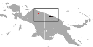
The golden-mantled tree-kangaroo is a critically endangered, furry, bear-like mammal found only in mountain rain forests on the island of New Guinea. Like other tree-kangaroos, it lives in trees and feeds on plant matter. It belongs to the macropod family (Macropodidae) with kangaroos, and carries its young in a pouch like other marsupials. The range is restricted to two small mountain areas in the north and it is threatened by hunting and habitat loss.
Bomberai Peninsula, otherwise known as the Bird's Beak Peninsula, is located in the Western New Guinea region, opposite to and to the south of the Bird's Head Peninsula. To the west lies the Sebakor Bay and to the south Kamrau Bay. Sabuda island lies off the western tip of the peninsula, and is separated from the mainland by Berau and Bintuni straits.

New Guinea is the world's second-largest island, with an area of 785,753 km2 (303,381 sq mi). Located in Oceania in the southwestern Pacific Ocean, the island is separated from Australia by the 150-kilometre wide Torres Strait, though both landmasses lie on the same continental shelf. Numerous smaller islands are located to the west and east.

The Papua conflict is an ongoing conflict in Western New Guinea between Indonesia and the Free Papua Movement. Subsequent to the withdrawal of the Dutch administration from the Netherlands New Guinea in 1962 and implementation of Indonesian administration in 1963, the Free Papua Movement has conducted a low-intensity guerrilla war against Indonesia through the targeting of its military, police, and civilian populations.
The History of Western New Guinea refers to the history of the Indonesian western half of the island of New Guinea and other smaller islands to its west. This region was previously named Irian Jaya. The eastern half of the island is Papua New Guinea.

The Berau Gulf, formerly the MacCleur Gulf, separates the Vogelkop (Doberai) and Bomberai Peninsulas of Western New Guinea. It opens on the Ceram Sea to the west and ends in Bintuni Bay to the east.

Southwest Papua is a province of Indonesia, and is a fraction of Western New Guinea. Despite being named southwest, it is a misnomer and this province is actually located in the northwest edge of Papua. The area that belongs to this province includes the Greater Sorong area which consists of Sorong City, Sorong Regency, South Sorong Regency, Maybrat Regency, Tambrauw Regency, and Raja Ampat Regency. The Draft Law (RUU) on the Establishment of the Southwest Papua Province has been passed into law and becomes the 38th province in Indonesia.


