
Soil salinity and dryland salinity are two problems degrading the environment of Australia. Salinity is a concern in most states, but especially in the south-west of Western Australia.

Western Australia (WA) is divided into regions according to a number of systems.
The Mid West region is one of the nine regions of Western Australia. It is a sparsely populated region extending from the west coast of Western Australia, about 200 kilometres (120 mi) north and south of its administrative centre of Geraldton and inland to 450 kilometres (280 mi) east of Wiluna in the Gibson Desert.

The Wheatbelt is one of nine regions of Western Australia defined as administrative areas for the state's regional development, and a vernacular term for the area converted to agriculture during colonisation. It partially surrounds the Perth metropolitan area, extending north from Perth to the Mid West region, and east to the Goldfields-Esperance region. It is bordered to the south by the South West and Great Southern regions, and to the west by the Indian Ocean, the Perth metropolitan area, and the Peel region. Altogether, it has an area of 154,862 square kilometres (59,793 sq mi).

The Peel region is one of the nine regions of Western Australia. It is located on the west coast of Western Australia, about 75 km (47 mi) south of the state capital, Perth. It consists of the City of Mandurah, and the Shires of Boddington, Murray, Serpentine-Jarrahdale and Waroona.

A telecentre is a public place where people can access computers, the Internet, and other digital technologies that enable them to gather information, create, learn, and communicate with others while they develop essential digital skills. Telecentres exist in almost every country, although they sometimes go by a different names including public internet access center (PIAP), village knowledge center, infocenter, Telecottage, Electronic Village Hall, community technology center (CTC), community multimedia center (CMC), multipurpose community telecentre (MCT), Common/Citizen Service Centre (CSC) and school-based telecentre. While each telecentre is different, their common focus is on the use of digital technologies to support community, economic, educational, and social development—reducing isolation, bridging the digital divide, promoting health issues, creating economic opportunities, and reaching out to youth for example.

Pinjarra is a town in the Peel region of Western Australia along the South Western Highway, 82 kilometres (51 mi) from the state capital, Perth and 21 kilometres (13 mi) south-east of the coastal city of Mandurah. Its local government area is the Shire of Murray. At the 2016 census, Pinjarra had a population of 4910.

Kulin is a town in the eastern Wheatbelt region of Western Australia, approximately 280 km from Perth. It is the main town in the Shire of Kulin.
St Alouarn Islands are a group of islands and rocks south-east of Cape Leeuwin in Western Australia, approximately 11 km south of Augusta in Flinders Bay.
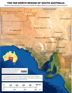
The Far North is a large region of South Australia close to the Northern Territory border. Colloquial usage of the term in South Australia refers to that part of South Australia north of a line roughly from Ceduna through Port Augusta to Broken Hill. The South Australian Government defines the Far North region similarly with the exception of the Maralinga Tjarutja Lands, the Yalata Aboriginal community and other unincorporated crown lands in the state's far west, which are officially considered part of the Eyre and Western region.

Ongerup is a town 410 kilometres (250 mi) south-east of Perth and 54 kilometres (34 mi) east of Gnowangerup in the Great Southern region of Western Australia. At the 2016 census Ongerup had a population of 93.

The Western Australian economy is a state economy dominated by its resources and services sector and largely driven by the export of iron-ore, gold, liquefied natural gas and agricultural commodities such as wheat. Covering an area of 2.5 million km2, the state is Australia's largest, accounting for almost one-third of the continent. Western Australia is the nation's fourth most populous state, with 2.6 million inhabitants.
The Conservation Council of Western Australia is the umbrella body for conservation groups and organisations in Western Australia. It has been the co-ordinator, publisher and guiding body for issues of woodchipping in the South West of Western Australia, the logging of old growth forests, as well as providing input into government processes involved with all aspects of environmental protection and conservation.
The Western Australian Planning Commission (WAPC) is an independent statutory authority of the Government of Western Australia that exists to coordinate strategic and statutory planning for future urban, rural and regional land use. The authority is responsible for expenditure arising from the Metropolitan Region Improvement Tax.

Westlink, formerly known as Westlink Network, was an Australian free-to-view digital television channel broadcast to regional and remote areas of Western Australia on the Viewer Access Satellite Television service. Funded by the Government of Western Australia, the channel was managed and operated by the Department of Regional Development and broadcast a range of community-based content, particularly training and educational programs, using an open-narrowcast licence. The channel was received in over 150 remote locations such as telecentres, schools and colleges.
Royalties for Regions is a political policy formulated by the National Party in 2008 which involves the redirection of Western Australian state government spending from the major population centres, particularly Perth, into the rural areas of the state. This spending would be funded by setting aside 25% of the state's mining and petroleum royalty revenue.
Pinjarra Senior High School is an independent high school in Pinjarra, a regional centre 86 kilometres (53 mi) south of Perth, Western Australia. The school district covers the Pinjarra and surrounding areas such as Serpentine, Dwellingup, Waroona, North Yunderup and South Yunderup.

The Asia-Pacific Telecentre Network (APTN) is a collaborative initiative of the United Nations Economic and Social Commission for Asia and the Pacific (UN-ESCAP) and telecentre.org. The APTN Secretariat is hosted at ICT Agency of Sri Lanka (ICTA). APTN is dedicated to promote innovation and knowledge sharing amongst telecentres in the Asia-Pacific region where telecentres are growing exponentially each year. APTN is working towards creating a platform of networks of telecentres, to share experiences on issues of their interest and to cooperate on the development of solutions for common problems of the telecentres themselves in order to empower poor and disadvantaged communities with Information and Communication Technology (ICT) in the Asia Pacific Region. In other words, APTN will serve as the focal network or the knowledge hub for communication and information technology in the Asia Pacific region.
The Carnamah Historical Society collects, records, preserves and promotes the history of Carnamah, a town and farming community in the Mid West region of Western Australia.
Land systems of Western Australia are systematic land resource concepts where the tying in of geographical, geological, and ecological data is processed to provide land planning and land management systems with sets of information that can process large areas of land in terms of agricultural and other usages.