
The Kansas River, also known as the Kaw, is a river in northeastern Kansas in the United States. It is the southwestern-most part of the Missouri River drainage, which is in turn the northwestern-most portion of the extensive Mississippi River drainage. Its two names both come from the Kanza (Kaw) people who once inhabited the area; Kansas was one of the anglicizations of the French transcription Cansez of the original kką:ze. The city of Kansas City, Missouri, was named for the river, as was later the state of Kansas.

The Republican River is a river in the central Great Plains of North America, rising in the High Plains of eastern Colorado and flowing east 453 miles (729 km) through the U.S. states of Nebraska and Kansas.

The Katy Trail State Park is a state park in the U.S. state of Missouri that contains the Katy Trail, a recreational rail trail that runs 240 miles (390 km) in the right-of-way of the former Missouri–Kansas–Texas Railroad. Running largely along the northern bank of the Missouri River, it is the country's longest rails-to-trails trail. The trail is open for use by hikers, joggers, and cyclists year-round, from sunrise to sunset. Its hard, flat surface is of "limestone pug".
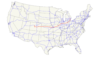
U.S. Route 24 is one of the original United States highways of 1926. It originally ran from Pontiac, Michigan, in the east to Kansas City, Missouri, in the west. Today, the highway's northern terminus is in Independence Township, Michigan, at an intersection with I-75 and its western terminus is near Minturn, Colorado at an intersection with I-70. The highway transitions from north–south to east–west signage in Toledo, Ohio.
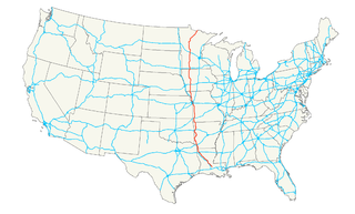
U.S. Route 71 is a major north–south United States highway that extends for over 1500 miles in the central United States. This original 1926 route has remained largely unchanged by encroaching Interstate highways. Currently, the highway's northern terminus is in International Falls, Minnesota at the Canada–US border, at the southern end of the Fort Frances-International Falls International Bridge to Fort Frances, Ontario. U.S. Route 53 also ends here. On the other side of the bridge, Trans-Canada Highway 11 is an east–west route. US 71's southern terminus is between Port Barre and Krotz Springs, Louisiana at an intersection with U.S. Route 190.
U.S. Highway 159 (US 159) is a 83.6-mile-long (134.5 km) auxiliary route of US 59. It travels from Nortonville, Kansas at US 59 to New Point, Missouri, also at US 59. The highway permits through traffic on US 59 to bypass the cities of Atchison, Kansas and Saint Joseph, Missouri.
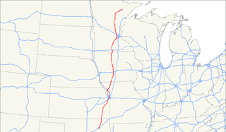
U.S. Route 169 currently runs for 966 miles (1,555 km) from the city of Virginia, Minnesota to Tulsa, Oklahoma at Memorial Drive.
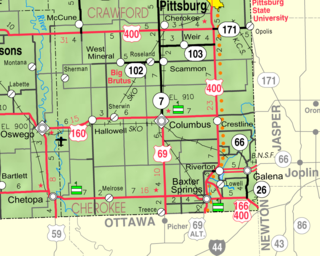
Riverton is an unincorporated community and census-designated place in Cherokee County, Kansas, United States. It is located at the junction of K-66 and U.S. Route 69 Alternate and U.S. Route 400, near the Spring River. It is one of only three towns in Kansas along former U.S. Route 66. As of the 2010 census, the CDP population was 929.
The Blue River is a 39.8-mile-long (64.1 km) stream that flows through Johnson County, Kansas, and Jackson County, Missouri, in the Kansas City Metropolitan Area. The river rises in Johnson County near the border of the states of Kansas and Missouri. Crossing the city of Kansas City, Missouri, it empties into the Missouri River near the border between Kansas City and Independence, Missouri.

The National Register of Historic Places in the United States is a register including buildings, sites, structures, districts, and objects. The Register automatically includes all National Historic Landmarks as well as all historic areas administered by the U.S. National Park Service. Since its introduction in 1966, more than 90,000 separate listings have been added to the register.
Route 9 is a highway in the Kansas City, Missouri area. Its northern terminus is at Interstate 29/U.S. Route 71 in Kansas City North; its southern terminus is at Interstate 35/Interstate 70/U.S. Route 24/U.S. Route 40 in downtown Kansas City. Even though both termini are in Kansas City, it passes through other towns and cities. It is carried across the Missouri River by the Heart of America Bridge between downtown Kansas City, Missouri and North Kansas City, MO. In North Kansas City, the highway serves as a main thoroughfare, Burlington Street.
Route 45 is a highway in northwest Missouri in Buchanan County, Missouri and Platte County, Missouri which is largely in the bottom land alongside of the Missouri River.

The Neosho River is a tributary of the Arkansas River in eastern Kansas and northeastern Oklahoma in the United States. Its tributaries also drain portions of Missouri and Arkansas. The river is about 463 miles (745 km) long. Via the Arkansas, it is part of the Mississippi River watershed. Its name is an Osage word meaning "clear water."
Interstate 635 (I-635) is a connector highway between Interstate 35 in Overland Park, Kansas and Interstate 29 in Kansas City, Missouri, approximately 12 miles long. It is mostly in the U.S. state of Kansas, servicing the city of Kansas City, Kansas, but extends into Kansas City, Missouri as well. The freeway's southern terminus is at a stack interchange with I-35. South of this, the mainline becomes an expressway carrying U.S. 69.

Forgottonia, also spelled Forgotonia, is the name given to a 16-county region in Western Illinois in the late 1960s and early 1970s. This geographic region forms the distinctive western bulge of Illinois that is roughly equivalent to "The Tract", the Illinois portion of the Military Tract of 1812, along and west of the Fourth Principal Meridian. Since this wedge-shaped region lies between the Illinois and Mississippi rivers, it has historically been isolated from the eastern portion of Central Illinois.

The Paseo Bridge was a suspension bridge over the Missouri River in Kansas City, Missouri. Before being replaced by the Christopher S. Bond Bridge, it carried Interstates 29 and 35 and U.S. Route 71 over the river. It was named for The Paseo, a boulevard that connected with the bridge to the south, and continues to do so with the Bond Bridge.

U.S. Route 50 (US 50) is a part of the U.S. Highway System that travels from West Sacramento, California, to Ocean City, Maryland. In the U.S. state of Colorado, US 50 is a major highway crossing through the lower midsection of the state. It connects the Western Slope with the lower Front Range and the Arkansas Valley. The highway serves the areas of Pueblo and Grand Junction as well as many other smaller areas along its corridor. The long term project to upgrade the highway from two lanes to a four lane expressway between Grand Junction and Montrose was completed in January 2005. Only about 25% of the remainder of highway 50 in Colorado is four lane expressway.
U.S. Route 36 in the state of Missouri is an expressway with many freeway sections, connecting Kansas to Illinois. From Cameron to the Illinois state line, it forms part of the principal route between Kansas City and Chicago, known as the Chicago–Kansas City Expressway.

Clements is an unincorporated community in Chase County, Kansas, United States.

