The Taupo Volcanic Zone (TVZ) is a volcanic area in the North Island of New Zealand that has been active for the past two million years and is still highly active. Mount Ruapehu marks its south-western end and the zone runs north-eastward through the Taupo and Rotorua areas and offshore into the Bay of Plenty. It is part of the larger Central Volcanic Region that extends further westward through the western Bay of Plenty to the eastern side of the Coromandel Peninsula and has been active for four million years. The Taupo Volcanic Zone is widening east–west at the rate of about 8 mm per year. It is named after Lake Taupo, the flooded caldera of the largest volcano in the zone.
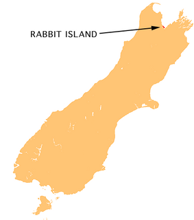
Moturoa / Rabbit Island is a small island located in the southernmost part of the Tasman Bay, in the northern coast of New Zealand's South Island. It lies across the southernmost part of Tasman Bay, at the top of New Zealand's South Island. The long narrow island runs east-west for 8 kilometres (5 mi), and covers 15 km2 (5.8 sq mi).

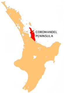
The Coromandel Range is a ridge of rugged hills running the length of the Coromandel Peninsula in the North Island of New Zealand. It is located 60 kilometres (37 mi) east of the city of Auckland, and runs north-south for approximately 85 kilometres. The highest point in the range is Mount Moehau, at the northern end of the peninsula within the Moehau Range. There are numerous peaks over 600 metres in height.

Cheltenham is a North-Eastern suburb of Auckland, New Zealand. It gets its name from the English town of Cheltenham, and provides a view of Rangitoto Island from its beachfront areas. The suburb is in the North Shore ward, one of the thirteen administrative divisions of Auckland Council. The area includes North Head, Cheltenham Beach, and Balmain Reserve.
Te Whiti, formerly Te Whiti o Tu in the nineteenth century, is a rural community in the Wairarapa region of New Zealand's North Island. Its status has been under dispute and threatened in the twentieth century, and Land Information New Zealand acknowledges Te Whiti solely as a homestead. Its full former name means "the place of crossing" in the Māori language, reflecting its location near a natural crossing of the Ruamahanga River, which runs north and west of the locality and is met by the Tauweru River that flows across the south of Te Whiti. In relation to major Wairarapa centres, Te Whiti is south of Masterton and east of Carterton, while nearby communities include Te Whanga to the east and Gladstone and Longbush to the south. The Maungaraki Range is also nearby.
Shipton Ridge is the main ridge forming the northeastern arm of the Allan Hills in Victoria Land. Reconnoitered by the New Zealand Antarctic Research Program (NZARP) Allan Hills Expedition, 1964. They named it after Eric Shipton, Himalayan mountaineer, because of his association with Professor N.E. Odell, for whom the adjacent Odell Glacier is named.
Rangitikei is an area in New Zealand that follows the course of State Highway 1, from just south of Waiouru with the QEII Army Memorial Museum, through Taihape, Mangaweka, Hunterville, Marton and Bulls, and then winds down a minor road to the coast at Turakina & Scott’s Ferry. Often overlooked when accessing many New Zealand "search" menus, the area is emerging as one of the last few "undiscovered" regions for both home-grown and international tourists.
The Kapowai River is a river in the Waikato Region of New Zealand. It is located on the Coromandel Peninsula, and flows north from its source inland from Tairua, reaching the sea at Whitianga Harbour
The Mahakirau River is a river of the Coromandel Peninsula in New Zealand's North Island. It flows east from its source in the Coromandel Range, reaching the sea at Whitianga Harbour southwest of Whitianga.
The Manaia River is a river of the Coromandel Peninsula in New Zealand's North Island. It flows north from its sources in the Coromandel Range, reaching the waters of the Hauraki Gulf at Manaia Harbour, 10 kilometres (6 mi) southwest of Coromandel.
The Opitonui River is a river of the Coromandel Peninsula in New Zealand's North Island. It flows north to reach the peninsula's east coast at Whangapoua Harbour, close to the small settlement of Te Rerenga.
The Ounuora River is a river of the Coromandel Peninsula in the Waikato Region of New Zealand's North Island. It flows generally east from the Coromandel Range, reaching the Whitianga Harbour close to the small settlement of Mill Creek, 5 kilometres (3 mi) southwest of Whitianga.
The Purangi River is a river of the Coromandel Peninsula in New Zealand's North Island. It flows north to reach Mercury Bay to the east of Whitianga.
The Rerewhakaaitu River is a river of the Wellington Region of New Zealand's North Island. It flows southeast from its sources in rough hill country southeast of Martinborough, reaching the Pacific Ocean 40 kilometres (25 mi) northeast of Cape Palliser.
The Tapu River is a river of the Coromandel Peninsula in New Zealand's North Island. It flows west from the Coromandel Range, reaching the Firth of Thames at the settlement of Tapu, approximately halfway between Thames and Coromandel.
The Taringamotu River is a river of the Manawatu-Wanganui Region of New Zealand's North Island. It rises at the southern end of the Hauhungaroa Range, flowing generally west to meet the Ongarue River, part of the Whanganui River system, close to the town of Taumarunui.
The Te Mata River is a river of the Coromandel Peninsula in New Zealand's North Island. It flows west to reach the Firth of Thames at the small settlement of Te Mata, 25 kilometres (16 mi) south of Coromandel.
The Waingawa River is a river of the Wellington Region of New Zealand's North Island. A major tributary of the Ruamahanga River, it flows generally southeast from its origins close to The Mitre, the highest peak of the Tararua Range. The Waingawa flows through the western suburbs of the city of Masterton and reaches the Ruamahanga 10 kilometres (6 mi) southeast of Carterton.

Baxter Glacier is a glacier nurtured by icefalls from Flight Deck Neve, flowing northeast between Flagship Mountain and Mount Davidson to enter Fry Glacier, in Convoy Range, Victoria Land. It was named by a 1976–77 Victoria University of Wellington Antarctic Expedition (VUWAE) field party after James K. Baxter, New Zealand poet and social critic.

Koriniti is a settlement 47 kilometres (29 mi) upriver from Whanganui, New Zealand, home to the Ngāti Pāmoana hapū of the iwi Te Āti Haunui-a-Pāpārangi.