
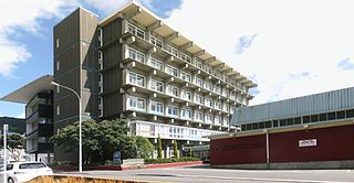
Whanganui, also spelled Wanganui, is a city in the Manawatū-Whanganui region of New Zealand. The city is located on the west coast of the North Island at the mouth of the Whanganui River, New Zealand's longest navigable waterway. Whanganui is the 19th most-populous urban area in New Zealand and the second-most-populous in Manawatū-Whanganui, with a population of 42,600 as of June 2022.
Michael Laws is a New Zealand politician, broadcaster and writer. Laws was a Member of Parliament for six years, starting in 1990, initially for the National Party. In Parliament he voted against his party on multiple occasions and in 1996 defected to the newly founded New Zealand First party, but resigned Parliament the same year following a scandal in which he selected a company part-owned by his wife for a government contract.

Whanganui Collegiate School is a state-integrated, coeducational, day and boarding, secondary school in Whanganui, Manawatū-Whanganui region, New Zealand. The school is affiliated to the Anglican church.

The Whanganui River is a major river in the North Island of New Zealand. It is the country's third-longest river, and has special status owing to its importance to the region's Māori people. In March 2017 it became the world's second natural resource to be given its own legal identity, with the rights, duties and liabilities of a legal person. The Whanganui Treaty settlement brought the longest-running litigation in New Zealand history to an end.
Wellington Girls' College was founded in 1883 in Wellington, New Zealand. At that time it was called Wellington Girls' High School. Wellington Girls' College is a year 9 to 13 state secondary school, located in Thorndon in central Wellington.
The 10th New Zealand Parliament was a term of the Parliament of New Zealand. Elections for this term were held in 4 Māori electorates and 91 European electorates on 7 and 26 September 1887, respectively. A total of 95 MPs were elected. Parliament was prorogued in October 1890. During the term of this Parliament, two Ministries were in power.

Whanganui High School is a large state co-educational New Zealand secondary school located in Whanganui, New Zealand. Founded in 1958, the school has a roll of 1479 students, including international students as of July 2018, making it the largest school in Whanganui.
Frances Ann Stewart was an Australian-born New Zealand social activist for women and children's rights. She was the first female member of a New Zealand hospital board.

De Lacy Evans O'Leary (1872–1957) was a British Orientalist who lectured at the University of Bristol and wrote a number of books on the early history of Arabs and Copts.

Anne Lysbeth Noble is a New Zealand photographer and Distinguished Professor of Fine Art (Photography) at Massey University's College of Creative Arts. Her work includes series of photographs examining Antarctica, her own daughter's mouth, and our relationship with nature.
Whanganui City College is located in Ingestre Street, Whanganui. It became Wanganui City College in 1994. It was formerly the Wanganui Technical College established in 1911 and it became Wanganui Boys' College in 1964.
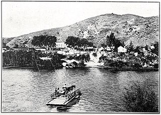
Upokongaro or Ūpokongaro is a settlement 12 kilometres (7.5 mi) upriver from Whanganui, New Zealand, in the Makirikiri Valley. Settled by Europeans in the 1860s, it was an important ferry crossing and riverboat stop. A spectacular discovery of moa bones was made in the area in the 1930s.
Peter Chapman Murray was a New Zealand rugby union player and politician. He played one Test for New Zealand in 1908, and was chairman of the Waimarino County Council from 1918 to 1926.

Marton railway station was a station and rail junction on the Marton–New Plymouth Line, opened on 4 February 1878. After the North Island Main Trunk (NIMT) made a junction to the south of Marton, a new station was built there and the old station renamed and downgraded, in 1898.

Putiki is a settlement in the Whanganui District and Manawatū-Whanganui region of New Zealand's North Island, located across the Whanganui River from Whanganui city. It includes the intersection of State Highway 3 and State Highway 4.
Whanganui East is a suburb of Whanganui, in the Whanganui District and Manawatū-Whanganui region of New Zealand's North Island.

College Estate is a suburb of Whanganui, in the Whanganui District and Manawatū-Whanganui region of New Zealand's North Island.

Castlecliff is a suburb of Whanganui, in the Whanganui District and Manawatū-Whanganui region of New Zealand's North Island. The name was given by the Harbour Board, on the suggestion of the future Prime Minister, John Ballance, when it established the township on what were described as "barren sandhills" in 1882. Many of the streets were named after Harbour Board members. The northern harbour breakwater extended 900 ft (270 m) by 1885. The freezing works was built in 1891.

Rangiwahia is a small, elevated, farming settlement in the North Island, New Zealand, 26 km (16 mi) northeast of Kimbolton in the Manawatū-Whanganui region. It is in the Kiwitea valley, near the Whanahuia Range of the Ruahines. Due to its height and the nearby ranges, Rangiwahia has a mean annual rainfall of 1267mm; 309mm more than Feilding's.
Whakahoro is a small settlement located south of Taumarunui on the junction of the Retaruke and Whanganui Rivers, about 104 mi (167 km) upstream from Whanganui. By gravel roads it is 41 km (25 mi) west of Raurimu and 44 km (27 mi) south west of Ōwhango.
