Wharfdale, New South Wales

Last updated

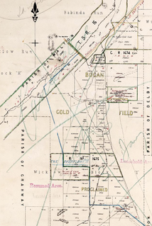
Wharfdale is a bounded rural locality, and cadastral parish south of Nyngan and west of Tottenham, New South Wales. [1] [2] [3]

Lands administrative divisions of Australia

Lands administrative divisions of Australia are the cadastral divisions of Australia for the purposes of identification of land to ensure security of land ownership. Most states term these divisions as counties, parishes, hundreds, and other terms. The eastern states of Queensland, New South Wales, Victoria and Tasmania were divided into counties and parishes in the 19th century, although the Tasmanian counties were renamed land districts in the 20th century. Parts of South Australia (south-east) and Western Australia (south-west) were similarly divided into counties, and there were also five counties in a small part of the Northern Territory. However South Australia has subdivisions of hundreds instead of parishes, along with the Northern Territory, which was part of South Australia when the hundreds were proclaimed. There were also formerly hundreds in Tasmania. There have been at least 600 counties, 544 hundreds and at least 15,692 parishes in Australia, but there are none of these units for most of the sparsely inhabited central and western parts of the country.

Nyngan Town in New South Wales, Australia

Nyngan is a town in the centre of New South Wales, Australia, in the Bogan Shire local government area within the Orana Region of central New South Wales. At the 2011 census, Nyngan had a population of 2,073 people. Nyngan is situated on the Bogan River between Narromine and Bourke, on the junction of the Mitchell Highway and Barrier Highway, 583 km north-west of Sydney by road. The Barrier Highway starts at Nyngan, and runs west to Cobar and on through Wilcannia and Broken Hill into South Australia.

Tottenham, New South Wales Town in New South Wales, Australia

Tottenham is a small town in Lachlan Shire in the Central West of New South Wales, Australia. Tottenham is known as “The Soul of the Centre”, a reference to it being the nearest town to the geographical centre of New South Wales. It had a population of 299 at the 2011 census, including 21 indigenous people (6%) and 20 foreign born people (6%).

Warfdale is located at 32°12′54″S 147°02′04″E and is in Bogan Shire and Flinders County. [4] Warfdale is one of the candidates for the geographic center of the state of New South Wales, [5] and is at an elevation 281 meters above sea level, [6]

Bogan Shire Local government area in New South Wales, Australia

Bogan Shire is a local government area in the Orana region of New South Wales, Australia. The Shire is located adjacent to the Mitchell and Barrier highways and its only significant town is Nyngan.

Flinders County Cadastral in New South Wales, Australia

Flinders County is one of the 141 Cadastral divisions of New South Wales. It is located to the south west of the Bogan River.
Elevation Height of a geographic location above a fixed reference point

The elevation of a geographic location is its height above or below a fixed reference point, most commonly a reference geoid, a mathematical model of the Earth's sea level as an equipotential gravitational surface . The term elevation is mainly used when referring to points on the Earth's surface, while altitude or geopotential height is used for points above the surface, such as an aircraft in flight or a spacecraft in orbit, and depth is used for points below the surface.

The area is named for Wharfedale in Yorkshire.

The original inhabitants of the area were the Wiradjuri Australian aboriginal tribe, and the first European to visit the area was Thomas Mitchell, who explored the area around the Bogan River in 1835.

The Wiradjuri people are a group of Indigenous Australian Aboriginal people that were united by a common language, strong ties of kinship and survived as skilled hunter–fisher–gatherers in family groups or clans scattered throughout central New South Wales.

Thomas Mitchell (explorer) Scottish surveyor and explorer in Australia

Lieutenant Colonel Sir Thomas Livingstone Mitchell, surveyor and explorer of south-eastern Australia, was born at Grangemouth in Stirlingshire, Scotland. In 1827 he took up an appointment as Assistant Surveyor General of New South Wales. The following year he became Surveyor General and remained in this position until his death. Mitchell was knighted in 1839 for his contribution to the surveying of Australia.
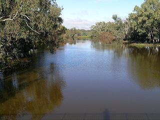
Bogan River river

Bogan River, a perennial river that is part of the Macquarie–Barwon catchment within the Murray–Darling basin, is located in the central west and Orana regions of New South Wales, Australia.

Today much of the area is incorporated into the Wharfedale State forest. [7]

Related Research Articles

South East Forests National Park Protected area in New South Wales, Australia

The South East Forests National Park is a national park located in between the Monaro and South Coast regions of New South Wales, Australia. The 115,177-hectare (284,610-acre) national park is situated 378 kilometres (235 mi) southwest of Sydney. It features high quality old growth eucalyptus forest and remnant patches of temperate rainforest.

Macquarie Marshes wetland in Australia

The Macquarie Marshes comprise the wetlands associated with the floodplains of the Macquarie River and its tributaries, in northern New South Wales, Australia. The Macquarie River and the marshes eventually drain into the Darling River. The marshes are important as a breeding site for waterbirds, especially in the aftermath of major floods.

Barwon River (New South Wales) river located in the Orana region of New South Wales, Australia

Barwon River, a perennial river that is part of the Murray–Darling basin, is located in the north-west slopes and Orana regions of New South Wales, Australia.

Kamilaroi Highway highway in New South Wales

The Kamilaroi Highway is a 605-kilometre (376 mi) state highway located in the north-western region of New South Wales, Australia. The highway's northwestern terminus is at a junction with the Mitchell Highway at Bourke. Its southeastern terminus is a junction with the New England Highway north of Willow Tree.

Little River (Dubbo), a watercourse of the Macquarie catchment within the Murray-Darling basin, is located in the central western and Orana districts of New South Wales, Australia.

The Billabong Creek, a perennial river of the Murrumbidgee catchment within the Murray-Darling basin, is located in the South West Slopes region of New South Wales, Australia.

Coolaburragundy River river in Australia

Coolaburragundy River, a perennial stream that is part of the Talbragar catchment within the Murray–Darling basin, is located in the Orana district of New South Wales, Australia.

Bell River, a watercourse that is part of the Macquarie catchment within the Murray–Darling basin, is located in the central west region of New South Wales, Australia.

Parish of Algalah Town in New South Wales, Australia

The parish of Algalah is an Australian cadastral parish in the NSW county of Narromine. It is located 367km west north west from Sydney approximately midway between Tottenham and Narromine and is in Narromine Shire, at 32°14′54″S147°49′04″E.

New South Wales Country Rugby Union

The New South Wales Country Rugby Union, or NSWCRU, is the governing body for the sport of rugby union within most of New South Wales in Australia.

The Overflow, New South Wales New South Wales, Australia

The Overflow is a bounded rural locality, cadastral parish and Sheep station, 100 kilometers south of Nyngan, New South Wales. It is located at 32°12′05″S 146°38′31″E on Gunningbar Creek near the junction with the Bogan River and is in Bogan Shire and Flinders County. The locality is 32 kilometers south of the town of Nymagee, and west of Tottenham, New South Wales.

Grahway, New South Wales New South Wales, Australia

Grahway is a bounded rural locality, and cadastral parish, 100 kilometers south of Nyngan, New South Wales. It is located at 32°12′05″S 146°38′31″E on Gunningbar Creek near the junction with the Bogan River and is in Bogan Shire and Flinders County.The locality is 32 kilometers south of the town of Nymagee, and west of Tottenham, New South Wales.

Delby, New South Wales

Delby' is a bounded rural locality, and cadastral parish, 100 kilometers south of Nyngan, New South Wales. It is located at 32°15′57″S 146°43′29″E on Gunningbar Creek near the junction with the Bogan River and is in Bogan Shire and Flinders County. The locality is south of the town of Nymagee, and west of Tottenham, New South Wales.

Walton, New South Wales

Walton is a bounded rural locality, and cadastral parish, 100 kilometers south of Nyngan, New South Wales. It is located at 32°10′26″S 146°34′16″E on Gunningbar Creek near the junction with the Bogan River and is in Bogan Shire and Flinders County. The locality is south of the town of Nymagee, and west of Tottenham, New South Wales.

The Ngiyampaa also known as the Ngemba, are an indigenous Australian people of the state of New South Wales.

Genaren Creek is a creek in central New South Wales.

Parish of Hume (Mouramba County)

Hume Parish in Mouramba County, central New South Wales is a cadasteral parish of Australia.

Gundy Parish is a civil parish of Gordon County, New South Wales. a Cadastral divisions of New South Wales.

References