
Harpers Ferry is a historic town in Jefferson County, West Virginia, in the lower Shenandoah Valley. The town's population was 269 at the 2020 United States census. Situated at the confluence of the Potomac and Shenandoah rivers, where Maryland, Virginia, and West Virginia meet, it is the easternmost town in West Virginia as well as its lowest point above sea level.

The Potomac River is a major river in the Mid-Atlantic region of the United States that flows from the Potomac Highlands in West Virginia to the Chesapeake Bay in Maryland. It is 405 miles (652 km) long, with a drainage area of 14,700 square miles (38,000 km2), and is the fourth-largest river along the East Coast of the United States. More than 6 million people live within its watershed.

The East Coast of the United States, also known as the Eastern Seaboard, the Atlantic Coast, and the Atlantic Seaboard, is the region encompassing the coastline where the Eastern United States meets the Atlantic Ocean. The Thirteen Colonies, which formed the United States in 1776 were located on this coast, and it has played an important role in the development of the United States.

Tangier is a town in Accomack County, Virginia, United States, on Tangier Island in the Chesapeake Bay. The population was 436 at the 2020 census. Since 1850, the island's landmass has been reduced by 67%. Under the mid-range sea level rise scenario, much of the remaining landmass is expected to be lost in the next 50 years and the town will likely need to be abandoned.

Wheeling is a city in Ohio and Marshall counties in the U.S. state of West Virginia. The county seat of Ohio County, it lies along the Ohio River in the foothills of the Appalachian Mountains within the state's Northern Panhandle. As of the 2020 census, the city had a population of 27,062, making it the fifth-most populous city in West Virginia and the most populous in the Northern Panhandle. The Wheeling metropolitan area had a population of 139,513 in 2020. Wheeling is located about 60 miles (97 km) west of Pittsburgh and 120 miles (190 km) east of Columbus via Interstate 70.

USS West Virginia (BB-48) was the fourth dreadnought battleship of the Colorado class, though because Washington was cancelled, she was the third and final member of the class to be completed. The Colorado class proved to be the culmination of the standard-type battleship series built for the United States Navy in the 1910s and 1920s; the ships were essentially repeats of the earlier Tennessee design, but with a significantly more powerful main battery of eight 16-inch (406 mm) guns in twin-gun turrets. West Virginia was built between her keel laying in 1920 and her commissioning into the Navy in 1923. The ship spent the 1920s and 1930s conducting routine training exercises, including the typically annual Fleet Problems, which provided invaluable experience for the coming war in the Pacific.

British North America comprised the colonial territories of the British Empire in North America from 1783 onwards. English colonisation of North America began in the 16th century in Newfoundland, then further south at Roanoke and Jamestown, Virginia, and more substantially with the founding of the Thirteen Colonies along the Atlantic coast of North America.

The James River is a river in Virginia that begins in the Appalachian Mountains and flows from the confluence of the Cowpasture and Jackson Rivers in Botetourt County 348 miles (560 km) to the Chesapeake Bay. The river length extends to 444 miles (715 km) if the Jackson River, the longer of its two headwaters, is included. It is the longest river in Virginia. Jamestown and Williamsburg, Virginia's first colonial capitals, and Richmond, Virginia's current capital, lie on the James River.
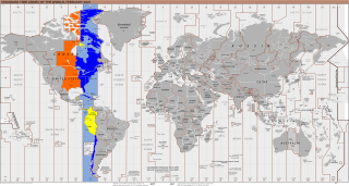
UTC−05:00 is an identifier for a time offset from UTC of −05:00. In North America, it is observed in the Eastern Time Zone during standard time, and in the Central Time Zone during the other eight months. The western Caribbean uses it year round.

U.S. Route 21 or U.S. Highway 21 (US 21) is a north–south United States Numbered Highway, spanning 393 miles (632 km) from Hunting Island State Park, South Carolina, to Wytheville, Virginia. The route traverses three states, South Carolina, North Carolina, and Virginia. It connects southeastern cities, including Columbia, South Carolina, and Charlotte, North Carolina.

The National Register of Historic Places in the United States is a register including buildings, sites, structures, districts, and objects. The Register automatically includes all National Historic Landmarks as well as all historic areas administered by the U.S. National Park Service. Since its introduction in 1966, more than 97,000 separate listings have been added to the register.

Blennerhassett Island Historical State Park is a state park located on Blennerhassett Island, a small island in the Ohio River, located in Wood County, West Virginia, USA. The property was the site of a Palladian mansion owned by Harman Blennerhassett, a participant in some of the alleged intrigues of Aaron Burr, and his wife Margaret Agnew. While the original mansion burned to the ground in 1811, a detailed replica, which can be toured, was built on its foundations in the 1980s. The Blennerhasset mansion greatly resembled George Washington's Mount Vernon, due to its Palladian style.
The Jug — formerly known as the Jug Handle — is a jug-shaped island formed by a horseshoe bend on Middle Island Creek near Middlebourne in Tyler County, West Virginia, USA. It is maintained by the state of West Virginia as The Jug Wildlife Management Area.
Wheeling Island is the most populated island in the Ohio River. It lies within the city of Wheeling in Ohio County, West Virginia, in the United States. The 2000 census showed a resident population of 3,142 people on the island, which has a land area of 1.514 square kilometres. Neville Island, Pennsylvania, is larger but has fewer people (1,232).

British America collectively refers to various European colonies in the Americas prior to the conclusion of the American Revolutionary War in 1783. The British monarchy of the Kingdom of England and Kingdom of Scotland—later named the Kingdom of Great Britain, of the British Isles and Western Europe—governed many colonies in the Americas beginning in 1585. From 1607, numerous permanent settlements were made from Hudson Bay, to the Mississippi River and the Caribbean Sea.

The steamship Virginia V is the last operational example of a Puget Sound Mosquito Fleet steamer. She was once part of a large fleet of small passenger and freight carrying ships that linked the islands and ports of Puget Sound in Washington state in the late 19th and early 20th centuries. She is a Seattle landmark and a National Historic Landmark.

The Ohio River Islands National Wildlife Refuge (ORINWR) is a National Wildlife Refuge (NWR) in non-contiguous sites consisting of islands along 362 miles (583 km) of the Ohio River, primarily in the U.S. state of West Virginia.

The Weirton–Steubenville, WV–OH Metropolitan Statistical Area, also known as the Upper Ohio Valley, is a metropolitan statistical area consisting of two counties in the Northern Panhandle of West Virginia and one in Ohio, anchored by the cities of Weirton and Steubenville. As of the 2020 census, the MSA had a population of 116,903. This puts it at 334th largest in the United States. It is also included in the larger Pittsburgh–New Castle–Weirton, PA–OH–WV Combined Statistical Area.
Island Branch is an unincorporated community located in Kanawha County, West Virginia, United States.
