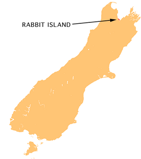
Moturoa / Rabbit Island is a small island located in the southernmost part of the Tasman Bay, in the northern coast of New Zealand's South Island. It lies across the southernmost part of Tasman Bay, at the top of New Zealand's South Island. The long narrow island runs east-west for 8 kilometres (5 mi), and covers 15 km2 (5.8 sq mi).

Ngatea is a small town on the Hauraki Plains in the North Island of New Zealand. It is located 18 kilometres southwest of Thames and 70 kilometres southeast of Auckland. Ngatea lies on the Piako River, eight kilometres south of its outflow into the Firth of Thames.
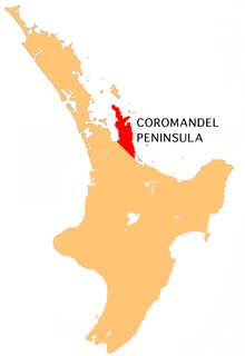
The Kapowai River is a river in the Waikato Region of New Zealand. It is located on the Coromandel Peninsula, and flows north from its source inland from Tairua, reaching the sea at Whitianga Harbour
The Kuaotunu River is a short river on the eastern Coromandel Peninsula on the North Island of New Zealand. It flows north towards the coast at Kuaotunu.
The Mahakirau River is a river of the Coromandel Peninsula in New Zealand's North Island. It flows east from its source in the Coromandel Range, reaching the sea at Whitianga Harbour southwest of Whitianga.
The Manaia River is a river of the Coromandel Peninsula in New Zealand's North Island. It flows north from its sources in the Coromandel Range, reaching the waters of the Hauraki Gulf at Manaia Harbour, 10 kilometres (6 mi) southwest of Coromandel.
The Moawhango River is a major river of the centre of New Zealand's North Island. It flows generally southwest from its sources in the Kaimanawa Range 35 kilometres (22 mi) east of Mount Ruapehu to reach Lake Moawhango at the southern end of the Rangipo Desert, 10 kilometres (6 mi) north of Waiouru. Some water is diverted from the lake for the Tongariro Power Scheme, while some is released to continue down the Moawhango River. From here, the river flows southeast, passing the small settlement of Moawhango before its outflow into the Rangitikei River 8 kilometres (5 mi) southeast of Taihape.
The Opitonui River is a river of the Coromandel Peninsula in New Zealand's North Island. It flows north to reach the peninsula's east coast at Whangapoua Harbour, close to the small settlement of Te Rerenga.
The Otama River is a river of the Coromandel Peninsula in New Zealand's North Island. A short river, it flows north from a peninsula on the Coromandel's northeast coast to reach the sea 5 kilometres (3 mi) east of Kuaotunu.
The Purangi River is a river of the Coromandel Peninsula in New Zealand's North Island. It flows north to reach Mercury Bay to the east of Whitianga.
The Puriri River is a river of the Waikato Region of New Zealand's North Island. It flows west close to the point where the Coromandel Peninsula joins the rest of the North Island, reaching the Waihou River 3 kilometres (2 mi) east of Turua.
The Tapu River is a river of the Coromandel Peninsula in New Zealand's North Island. It flows west from the Coromandel Range, reaching the Firth of Thames at the settlement of Tapu, approximately halfway between Thames and Coromandel.
The Te Mata River is a river of the Coromandel Peninsula in New Zealand's North Island. It flows west to reach the Firth of Thames at the small settlement of Te Mata, 25 kilometres (16 mi) south of Coromandel.
The Waitekuri River is a river of the Coromandel Peninsula in New Zealand's North Island. It flows east from its sources in the Coromandel Range east of Coromandel to reach Whangapoua Harbour four kilometres south of Whangapoua.
The Waiwawa River is the longest river on the Coromandel Peninsula, in the Waikato Region of New Zealand's North Island. It flows initially northwest from its sources on the slopes of Mount Rowe before turning northeast to reach the southern end of the Whitianga Harbour.
The Waiwhango River is a river of the northern Coromandel Peninsula, in the Waikato Region of New Zealand's North Island. It flows generally southwest to reach the small Koputauaki Bay on the Hautapu Channel five kilometres northwest of Coromandel.
The Whangamaroro River is a short river of the Coromandel Peninsula, in the Waikato Region of New Zealand's North Island. It flows east to reach a northwestern arm of Whitianga Harbour
The Waikawau River is a river of the Coromandel Peninsula in New Zealand's North Island. It flows generally west from its sources in the Coromandel Range, reaching the Firth of Thames 2 kilometres (1.2 mi) north of Tapu.
State Highway 25 is a North Island state highway in New Zealand that loops around the Coromandel Peninsula. It is a major route for holidaymakers and tourists which has access to some of New Zealand's most idyllic beach holiday spots. The summer period around Christmas and New Year's Eve is a particularly busy period for the highway. The road is very scenic, but also windy in many parts as well as single carriage on the entire route, and is prone to accidents. It is New Zealand's third longest two-digit state highway, after SH 35 and SH 94. It is part of the Pacific Coast Highway.